TopoQuest Logo
Do you find TopoQuest useful?
Help keep TopoQuest running and adding new maps/features by donating!
Bitcoin:  19c7KJd3qBynnjoSw5npx9KScwjBe4ifkT
Litecoin:  LXs6TkuXGGXo1vDsWCkWVdjQX94eUKd6ui
Home View Maps Find Maps Find Places Resources & Links


Eagle Creek, Tennessee Topographic Map

USGS Map Title: Eagle Creek, TN
USGS Map MRC: 35087C8
DRG (GeoTIFF) Download: o35087c8.tif


Neighboring USGS Topographic Map Quads:


  Bath Springs, TN  
35088D1
 

  Clifton, TN  
35087D8
 

  Leatherwood, TN  
35087D7
 

  Olivehill, TN  
35088C1
 

  Eagle Creek, TN  
35087C8
 

  Waynesboro, TN  
35087C7
 

  Wolf Pit Ridge, TN  
35088B1
 

  Martins Mills, TN  
35087B8
 

  Three Churches, TN  
35087B7


Map MRC Location:

N36°
W88°
N36°
W87°
H8 H7 H6 H5 H4 H3 H2 H1
G8 G7 G6 G5 G4 G3 G2 G1
F8 F7 F6 F5 F4 F3 F2 F1
E8 E7 E6 E5 E4 E3 E2 E1
D8 D7 D6 D5 D4 D3 D2 D1
C8 C7 C6 C5 C4 C3 C2 C1
B8 B7 B6 B5 B4 B3 B2 B1
A8 A7 A6 A5 A4 A3 A2 A1
N35°
W88°
N35°
W87°

Eagle Creek, TN USGS 1:24K Topographic Map Preview:
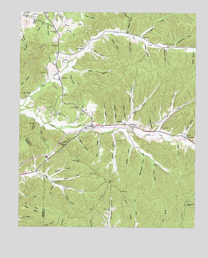
Eagle Creek, TN USGS Topographic Map
Click on map above to begin viewing in our Map Viewer.

This topographic map contains these locations and features:
Feature Name Type Latitude Longitude GNIS ID View Map
Alley SpringSpringN35.3367°W87.9707°1275614View Map
Arnold Hollow SpringSpringN35.2643°W87.8797°1275895View Map
Barber HollowValleyN35.3525°W87.8758°1276285View Map
Beckham HollowValleyN35.2787°W87.9776°1276741View Map
Bethany ChurchChurchN35.2759°W87.9748°1277080View Map
Bingham BranchStreamN35.3670°W87.9675°1277480View Map
Blackshire CemeteryCemeteryN35.3153°W87.9711°1305274View Map
Bloody BranchStreamN35.3045°W87.9017°1277706View Map
Bloody Branch CemeteryCemeteryN35.3145°W87.8967°1641756View Map
Boyd CemeteryCemeteryN35.3042°W87.8828°1641758View Map
Boyd-Lynch CemeteryCemeteryN35.3251°W87.9717°1641759View Map
Bromley HollowValleyN35.3042°W87.8822°1278458View Map
Brown CemeteryCemeteryN35.3120°W87.9211°1641765View Map
Brown HollowValleyN35.3052°W87.9334°1305453View Map
Bryant RidgeRidgeN35.2604°W87.9959°1278755View Map
Buck HollowValleyN35.3533°W87.9499°1278816View Map
Burns HollowValleyN35.3146°W88.0000°1279090View Map
Butler HollowValleyN35.3125°W87.9255°1279186View Map
Cave SpringSpringN35.3620°W87.9345°1641770View Map
Cedar SpringSpringN35.3554°W87.9731°1280096View Map
Clifton JunctionPopulated PlaceN35.3087°W87.9489°1314857View Map
Cook CemeteryCemeteryN35.3156°W87.9761°1281108View Map
Davidson HillSummitN35.2987°W87.9695°1282107View Map
Davis HillSummitN35.2709°W87.9272°1302733View Map
Davis RidgeRidgeN35.2617°W87.9220°1282202View Map
Dickson Bluff RidgeRidgeN35.2970°W87.9911°1302735View Map
Dicus CemeteryCemeteryN35.3606°W87.9125°1282463View Map
Dicus HollowValleyN35.3604°W87.9217°1282464View Map
Dillion HollowValleyN35.3691°W87.9808°1282477View Map
Dove HollowValleyN35.3092°W87.9845°1282752View Map
Dugout HillSummitN35.3731°W87.9253°1283106View Map
Dugout HollowValleyN35.3635°W87.9251°1283107View Map
Eagle Creek Volunteer Fire DepartmentBuildingN35.3624°W87.9198°2654166View Map
Elliott CemeteryCemeteryN35.3467°W87.9695°1283668View Map
Evans ChapelChurchN35.3537°W87.9553°1283904View Map
Evans Chapel CemeteryCemeteryN35.3553°W87.9556°1641793View Map
Farris HollowValleyN35.3099°W87.9389°1284159View Map
Flat Gap CemeteryCemeteryN35.2792°W87.9786°1641795View Map
Flat Gap School (historical)SchoolN35.2754°W87.9731°1302743View Map
Franks HollowValleyN35.2774°W87.9758°1284840View Map
Friendship Baptist Church (historical)ChurchN35.3559°W87.8956°1641802View Map
Friendship CemeteryCemeteryN35.3562°W87.8947°1284924View Map
Gant RidgeRidgeN35.2648°W87.9431°1285137View Map
Goforth BranchStreamN35.3434°W87.9664°1285572View Map
Goober CreekStreamN35.3598°W87.9153°1285604View Map
Graham HollowValleyN35.3180°W87.9191°1285807View Map
Grigg CemeteryCemeteryN35.3395°W87.9817°1286293View Map
Grimes CemeteryCemeteryN35.3048°W87.9189°1286297View Map
Haggard CemeteryCemeteryN35.3081°W87.8986°1286491View Map
Haggard CemeteryCemeteryN35.3734°W87.9909°1286492View Map
Haggard HollowValleyN35.3062°W87.9070°1286493View Map
Hardins Creek Fire TowerTowerN35.2709°W87.9272°1646838View Map
Helton HollowValleyN35.3565°W87.9094°1287354View Map
Hendricks HollowValleyN35.3538°W87.8963°1287396View Map
Hideout HollowValleyN35.3405°W87.9731°1287680View Map
Hill HollowValleyN35.2739°W87.9745°1287800View Map
Hollandsworth HollowValleyN35.2921°W87.9106°1288067View Map
Hughes HillSummitN35.3504°W87.9842°1302762View Map
Hutton CemeteryCemeteryN35.3001°W87.9314°1288877View Map
Joe HollowValleyN35.3329°W87.9773°1289465View Map
Keeton HollowValleyN35.3057°W87.9588°1289966View Map
Lizard Glade CemeteryCemeteryN35.3740°W87.9950°1291743View Map
Lynn HollowValleyN35.2891°W87.9053°1292355View Map
Marion Furnace (historical)LocaleN35.3509°W87.9948°1641846View Map
Mill CreekStreamN35.3067°W87.9311°1293836View Map
Mill SpringSpringN35.3028°W87.8801°1293893View Map
Mills Spring BranchStreamN35.2973°W87.8789°1646847View Map
Montague CemeteryCemeteryN35.3115°W87.9311°1294178View Map
Moore CemeteryCemeteryN35.2903°W87.9795°1294255View Map
Moore CemeteryCemeteryN35.3192°W87.9809°1294256View Map
Mosier BranchStreamN35.3092°W87.9222°1294488View Map
Philadelphia CemeteryCemeteryN35.3095°W87.9172°1641880View Map
Philadelphia ChurchChurchN35.3090°W87.9175°1297310View Map
Philadelphia School (historical)SchoolN35.3101°W87.9153°1641881View Map
Pitts HollowValleyN35.3042°W87.9422°1297763View Map
Roberts CemeteryCemeteryN35.3534°W87.9700°1641893View Map
Roberts HollowValleyN35.3626°W87.9370°1299639View Map
Sanders MineMineN35.3709°W87.9853°1641899View Map
Schote HollowValleyN35.3706°W87.9804°1300906View Map
Shady Grove School (historical)SchoolN35.3201°W87.9817°1302796View Map
Sheep Cave HollowValleyN35.3111°W87.9884°1269957View Map
Shell HollowValleyN35.3013°W87.8878°1270004View Map
Shipman HollowValleyN35.3103°W87.9316°1270121View Map
Sorby (historical)Populated PlaceN35.3029°W87.8820°1302798View Map
South Central Correctional FacilityBuildingN35.3666°W87.9987°2766000View Map
Tanyard HollowValleyN35.2728°W87.9690°1272109View Map
Tarkiln HollowValleyN35.3406°W87.9659°1272128View Map
Throgmartin HollowValleyN35.3555°W87.8899°1272594View Map
Tune BranchStreamN35.3084°W87.9614°1272977View Map
Tune CemeteryCemeteryN35.3159°W87.9542°1272978View Map
Turney Center Industrial Complex AnnexBuildingN35.3702°W87.9916°2766001View Map
Walker CemeteryCemeteryN35.3565°W87.8909°1273585View Map
Walker HollowValleyN35.3180°W87.8915°1273625View Map
Walker SpringSpringN35.3277°W87.9924°1273647View Map
Webster HollowValleyN35.2983°W87.9203°1274054View Map
White CemeteryCemeteryN35.2828°W87.9889°1323987View Map
White CemeteryCemeteryN35.2820°W87.9947°1323988View Map

Note: Coordinates in the location and feature list above are referenced to NAD83 datum.


Copyright (C) 2008-2024 Ryan Niemi / Sunset Dynamics ... All Rights Reserved