TopoQuest Logo
Do you find TopoQuest useful?
Help keep TopoQuest running and adding new maps/features by donating!
Bitcoin:  19c7KJd3qBynnjoSw5npx9KScwjBe4ifkT
Litecoin:  LXs6TkuXGGXo1vDsWCkWVdjQX94eUKd6ui
Home View Maps Find Maps Find Places Resources & Links


Durham, New York Topographic Map

USGS Map Title: Durham, NY
USGS Map MRC: 42074D2
DRG (GeoTIFF) Download: o42074d2.tif


Neighboring USGS Topographic Map Quads:


  Middleburgh, NY  
42074E3
 

  Rensselaerville, NY  
42074E2
 

  Westerlo, NY  
42074E1
 

  Livingstonville, NY  
42074D3
 

  Durham, NY  
42074D2
 

  Greenville, NY  
42074D1
 

  Ashland, NY  
42074C3
 

  Hensonville, NY  
42074C2
 

  Freehold, NY  
42074C1


Map MRC Location:

N43°
W75°
N43°
W74°
H8 H7 H6 H5 H4 H3 H2 H1
G8 G7 G6 G5 G4 G3 G2 G1
F8 F7 F6 F5 F4 F3 F2 F1
E8 E7 E6 E5 E4 E3 E2 E1
D8 D7 D6 D5 D4 D3 D2 D1
C8 C7 C6 C5 C4 C3 C2 C1
B8 B7 B6 B5 B4 B3 B2 B1
A8 A7 A6 A5 A4 A3 A2 A1
N42°
W75°
N42°
W74°

Durham, NY USGS 1:24K Topographic Map Preview:
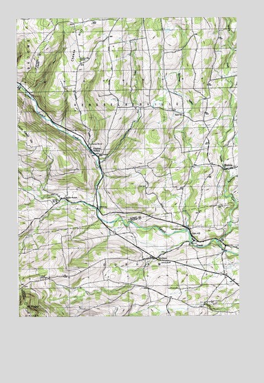
Durham, NY USGS Topographic Map
Click on map above to begin viewing in our Map Viewer.

This topographic map contains these locations and features:
Feature Name Type Latitude Longitude GNIS ID View Map
Brookside CemeteryCemeteryN42.4427°W74.2050°944867View Map
Central School (historical)SchoolN42.3973°W74.1637°946292View Map
Cheese HillSummitN42.4862°W74.2140°946468View Map
Cheese Hill School (historical)SchoolN42.4817°W74.2138°946469View Map
CooksburgPopulated PlaceN42.4206°W74.2051°947363View Map
Craw School (historical)SchoolN42.4290°W74.1771°947714View Map
DurhamPopulated PlaceN42.3995°W74.1724°948832View Map
Durham CemeteryCemeteryN42.3862°W74.1591°948833View Map
Durham Elementary SchoolSchoolN42.3972°W74.1641°2668834View Map
Durham Police DepartmentBuildingN42.4030°W74.1323°2766653View Map
Durham United Methodist ChurchChurchN42.3996°W74.1740°2615852View Map
Eightmile CreekStreamN42.4315°W74.1312°949438View Map
Fox CreekStreamN42.4409°W74.2038°970145View Map
Heather Ridge FarmLocaleN42.4314°W74.2383°2555046View Map
MedusaPopulated PlaceN42.4367°W74.1301°956907View Map
Mount PisgahSummitN42.3773°W74.2449°960635View Map
Oak HillPopulated PlaceN42.4098°W74.1524°959100View Map
Oak Hill CemeteryCemeteryN42.4120°W74.1606°959125View Map
Oak Hill Durham Volunteer Fire CompanyBuildingN42.4055°W74.1545°2718483View Map
Potter HollowPopulated PlaceN42.4251°W74.2232°961041View Map
Potter Hollow Census Designated PlaceCensusN42.4354°W74.2332°2628180View Map
Pratt CemeteryCemeteryN42.4212°W74.1365°961095View Map
Preston HollowPopulated PlaceN42.4445°W74.2079°961126View Map
Preston Hollow Census Designated PlaceCensusN42.4257°W74.1921°2628182View Map
Preston-Potter Hollow Census Designated PlaceCensusN42.4330°W74.2288°2389706View Map
Rensselaerville Volunteer AmbulanceBuildingN42.4561°W74.1431°2720167View Map
Sayer School (historical)SchoolN42.4590°W74.1557°964550View Map
School Number 14 (historical)SchoolN42.4470°W74.2082°975079View Map
School Number 19 (historical)SchoolN42.4237°W74.2265°975148View Map
Squirmer ValleyValleyN42.4112°W74.1540°966178View Map
Tenmile CreekStreamN42.4040°W74.1351°967157View Map
Town of DurhamCivilN42.3758°W74.1466°978913View Map
Town of RensselaervilleCivilN42.4752°W74.1742°979415View Map
West DurhamPopulated PlaceN42.3906°W74.2357°969208View Map
West Durham CemeteryCemeteryN42.3902°W74.2398°2547528View Map

Note: Coordinates in the location and feature list above are referenced to NAD83 datum.


Copyright (C) 2008-2024 Ryan Niemi / Sunset Dynamics ... All Rights Reserved