TopoQuest Logo
Do you find TopoQuest useful?
Help keep TopoQuest running and adding new maps/features by donating!
Bitcoin:  19c7KJd3qBynnjoSw5npx9KScwjBe4ifkT
Litecoin:  LXs6TkuXGGXo1vDsWCkWVdjQX94eUKd6ui
Home View Maps Find Maps Find Places Resources & Links


Drummond, Michigan Topographic Map

USGS Map Title: Drummond, MI
USGS Map MRC: 46083A6
DRG (GeoTIFF) Download: o46083a6.tif


Neighboring USGS Topographic Map Quads:


  Burnt Island, MI  
46083A7
 

  Drummond, MI  
46083A6
 

  Drummond SE, MI  
46083A5
 

  Whitney Bay, MI  
45083H7
 

  Meade Island, MI  
45083H6
 

  Marble Head, MI  
45083H5


Map MRC Location:

N47°
W84°
N47°
W83°
H8 H7 H6 H5 H4 H3 H2 H1
G8 G7 G6 G5 G4 G3 G2 G1
F8 F7 F6 F5 F4 F3 F2 F1
E8 E7 E6 E5 E4 E3 E2 E1
D8 D7 D6 D5 D4 D3 D2 D1
C8 C7 C6 C5 C4 C3 C2 C1
B8 B7 B6 B5 B4 B3 B2 B1
A8 A7 A6 A5 A4 A3 A2 A1
N46°
W84°
N46°
W83°

Drummond, MI USGS 1:24K Topographic Map Preview:
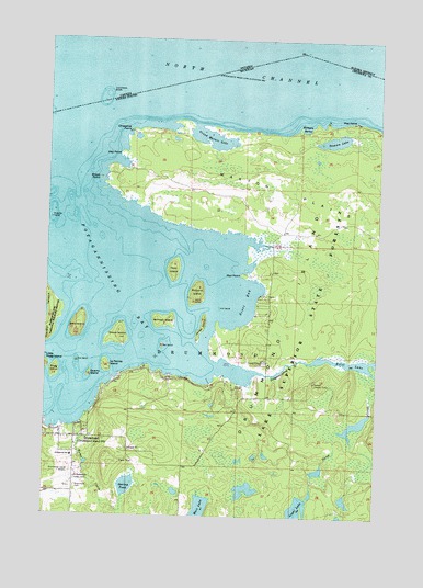
Drummond, MI USGS Topographic Map
Click on map above to begin viewing in our Map Viewer.

This topographic map contains these locations and features:
Feature Name Type Latitude Longitude GNIS ID View Map
Ashman IslandIslandN46.0514°W83.7058°620275View Map
Ashman Island Seaplane BaseAirportN46.0686°W83.7242°1623874View Map
Bald IslandIslandN46.0495°W83.7381°620500View Map
Bay IslandIslandN46.0447°W83.7064°620783View Map
Betsy Seamon Memorial ParkParkN46.0225°W83.7472°2356329View Map
Bruce PointCapeN46.0886°W83.7303°622124View Map
Chippewa BankLeveeN46.1042°W83.7103°1617301View Map
Chippewa BankBarN46.1078°W83.7300°623212View Map
Chippewa PointCapeN46.1009°W83.7194°623224View Map
Dawson LakeLakeN46.0988°W83.6421°624369View Map
DrummondPopulated PlaceN46.0200°W83.7311°1617360View Map
Drummond CemeteryCemeteryN46.0072°W83.7378°624892View Map
Drummond IslandIslandN46.0000°W83.6667°1623175View Map
Drummond Island AirportAirportN46.0094°W83.7393°1623873View Map
Drummond Island Baptist ChurchChurchN46.0206°W83.7383°2356327View Map
Drummond Island Golf ClubLocaleN46.0067°W83.7428°2356333View Map
Drummond Island Historical MuseumBuildingN46.0225°W83.7472°2356328View Map
Drummond Island Indian CemeteryCemeteryN46.0092°W83.7380°2774388View Map
Drummond Island LibraryBuildingN46.0156°W83.7400°2356320View Map
Drummond Island Medical CenterHospitalN46.0128°W83.7389°2356330View Map
Drummond Island Post OfficePost OfficeN46.0192°W83.7356°1617357View Map
Drummond Island Sports CenterLocaleN46.0347°W83.7236°1617363View Map
Drummond Island Township HallBuildingN46.0206°W83.7383°2356325View Map
Drummond Island Volunteer Fire and RescueBuildingN46.0161°W83.7399°2356326View Map
Drummond Island Yacht Haven RampLocaleN46.0250°W83.7497°1617356View Map
Drummond SchoolSchoolN46.0153°W83.7394°624894View Map
Drummond Township Ambulance ServiceBuildingN46.0190°W83.7402°2662035View Map
Fire IslandIslandN46.0403°W83.7383°625980View Map
Grand Marais LakeBayN46.0992°W83.6892°627098View Map
Grape IslandIslandN46.0467°W83.7219°627165View Map
H and H Cabins and CampgroundLocaleN46.0247°W83.7494°2356319View Map
Hand H MarinaLocaleN46.0231°W83.7425°1617359View Map
Hay PointCapeN46.0950°W83.7231°627976View Map
James IslandIslandN46.0497°W83.6911°629202View Map
Jim IslandIslandN46.0547°W83.6850°629284View Map
Kemp CreekStreamN46.0234°W83.7389°629565View Map
La Pointe IslandIslandN46.0392°W83.7269°629908View Map
Lighthouse Christian ChurchChurchN46.0203°W83.7406°2356331View Map
Little Rogg IslandIslandN46.0395°W83.7497°630752View Map
Loyal LakeLakeN46.0018°W83.6540°631194View Map
Lykes Dock RampLocaleN46.0356°W83.7214°1617361View Map
Matthews CemeteryCemeteryN46.0210°W83.6861°2774389View Map
MaxtonPopulated PlaceN46.0339°W83.6758°1617364View Map
Maxton Bay CampgroundLocaleN46.0408°W83.6764°2354355View Map
Maxton Lookout TowerTowerN46.0353°W83.6486°1623507View Map
Maxton PlainsFlatN46.0853°W83.6603°631759View Map
Maxton Post Office (historical)Post OfficeN46.0339°W83.6758°2354356View Map
Mossings ResortLocaleN46.0392°W83.7119°1617362View Map
Paw PointCapeN46.0636°W83.6761°634494View Map
Peck IslandIslandN46.0645°W83.7025°634546View Map
Poe PointCapeN46.1039°W83.6353°635160View Map
Potagannissing RiverStreamN46.0381°W83.6700°635333View Map
Propeller IslandIslandN46.0778°W83.7489°635474View Map
Quarry IslandIslandN46.0370°W83.7339°635552View Map
Rogg IslandIslandN46.0378°W83.7467°636125View Map
Rutland IslandIslandN46.0589°W83.6936°636427View Map
Saint Florence ChurchChurchN46.0097°W83.7378°636634View Map
Scott BayBayN46.0567°W83.6753°637459View Map
Spring PondLakeN46.0079°W83.7185°638608View Map
Stony CreekStreamN46.0395°W83.6311°638901View Map
Township of DrummondCivilN46.0145°W83.6850°1626193View Map
Walkters HarborBayN46.1020°W83.6533°1615706View Map

Note: Coordinates in the location and feature list above are referenced to NAD83 datum.


Copyright (C) 2008-2024 Ryan Niemi / Sunset Dynamics ... All Rights Reserved