TopoQuest Logo
Do you find TopoQuest useful?
Help keep TopoQuest running and adding new maps/features by donating!
Bitcoin:  19c7KJd3qBynnjoSw5npx9KScwjBe4ifkT
Litecoin:  LXs6TkuXGGXo1vDsWCkWVdjQX94eUKd6ui
Home View Maps Find Maps Find Places Resources & Links


Donahue, Iowa Topographic Map

USGS Map Title: Donahue, IA
USGS Map MRC: 41090F6
DRG (GeoTIFF) Download: o41090f6.tif


Neighboring USGS Topographic Map Quads:


  Wheatland, IA  
41090G7
 

  Grand Mound, IA  
41090G6
 

  De Witt, IA  
41090G5
 

  Dixon, IA  
41090F7
 

  Donahue, IA  
41090F6
 

  Eldridge, IA  
41090F5
 

  Walcott, IA  
41090E7
 

  Davenport West, IA  
41090E6
 

  Davenport East, IA  
41090E5


Map MRC Location:

N42°
W91°
N42°
W90°
H8 H7 H6 H5 H4 H3 H2 H1
G8 G7 G6 G5 G4 G3 G2 G1
F8 F7 F6 F5 F4 F3 F2 F1
E8 E7 E6 E5 E4 E3 E2 E1
D8 D7 D6 D5 D4 D3 D2 D1
C8 C7 C6 C5 C4 C3 C2 C1
B8 B7 B6 B5 B4 B3 B2 B1
A8 A7 A6 A5 A4 A3 A2 A1
N41°
W91°
N41°
W90°

Donahue, IA USGS 1:24K Topographic Map Preview:
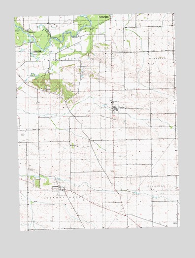
Donahue, IA USGS Topographic Map
Click on map above to begin viewing in our Map Viewer.

This topographic map contains these locations and features:
Feature Name Type Latitude Longitude GNIS ID View Map
Allens GroveLocaleN41.7000°W90.7043°466069View Map
Allens Grove CemeteryCemeteryN41.7067°W90.7279°454139View Map
Allens Grove County ParkParkN41.7486°W90.6807°464949View Map
Allens Grove Post Office (historical)Post OfficeN41.7009°W90.7079°466621View Map
Allens Grove School (historical)SchoolN41.7025°W90.7143°465051View Map
Amity Post Office (historical)Post OfficeN41.6489°W90.7288°466620View Map
Buena VistaPopulated PlaceN41.7420°W90.7404°464479View Map
Buena Vista County ParkParkN41.7281°W90.7304°464950View Map
Buenavista Post Office (historical)Post OfficeN41.7420°W90.7432°2000636View Map
Burch CemeteryCemeteryN41.6581°W90.6761°464948View Map
Cameron Woods State PreserveParkN41.6575°W90.7340°2046266View Map
City of DonahueCivilN41.6915°W90.6746°2394542View Map
City of MaysvilleCivilN41.6495°W90.7185°2395054View Map
DonahuePopulated PlaceN41.6948°W90.6754°455950View Map
Donahue (historical)LocaleN41.6948°W90.6754°2046543View Map
Donahue Post OfficePost OfficeN41.6948°W90.6754°2046544View Map
Donahue School (historical)SchoolN41.7014°W90.6749°465068View Map
Donahue Station Post Office (historical)Post OfficeN41.6978°W90.6751°466622View Map
Donahue Volunteer Fire DepartmentBuildingN41.6967°W90.6758°2577175View Map
Drumonds Camp (historical)LocaleN41.7381°W90.7013°465070View Map
Hickory GrovePopulated PlaceN41.6548°W90.7496°465346View Map
Hickory Grove Post Office (historical)Post OfficeN41.6667°W90.6946°2046244View Map
John Glenn Elementary SchoolSchoolN41.6986°W90.6762°464951View Map
Lamb of God Lutheran MissionChurchN41.6948°W90.6754°2046545View Map
Linn Grove CemeteryCemeteryN41.6693°W90.6897°2046584View Map
Linn Grove Independent School (historical)SchoolN41.6689°W90.7438°465110View Map
Linn Grove School (historical)SchoolN41.6703°W90.6913°465111View Map
MaysvillePopulated PlaceN41.6486°W90.7168°458874View Map
Maysville CemeteryCemeteryN41.6503°W90.7182°2046586View Map
Maysville Fire DepartmentBuildingN41.6496°W90.7173°2577396View Map
O'Toole CemeteryCemeteryN41.6500°W90.7335°2046585View Map
Sand Hill School (historical)SchoolN41.7278°W90.6746°465158View Map
Stender AirportAirportN41.6608°W90.7422°466871View Map
Township of Allens GroveCivilN41.7179°W90.7252°467388View Map
Township of Hickory GroveCivilN41.6411°W90.7259°468032View Map
Walnut CreekStreamN41.7439°W90.7460°462641View Map
West Maysville Independent School (historical)SchoolN41.6492°W90.7240°465181View Map

Note: Coordinates in the location and feature list above are referenced to NAD83 datum.


Copyright (C) 2008-2024 Ryan Niemi / Sunset Dynamics ... All Rights Reserved