TopoQuest Logo
Do you find TopoQuest useful?
Help keep TopoQuest running and adding new maps/features by donating!
Bitcoin:  19c7KJd3qBynnjoSw5npx9KScwjBe4ifkT
Litecoin:  LXs6TkuXGGXo1vDsWCkWVdjQX94eUKd6ui
Home View Maps Find Maps Find Places Resources & Links


Domestic, Indiana Topographic Map

USGS Map Title: Domestic, IN
USGS Map MRC: 40085E1
DRG (GeoTIFF) Download: o40085e1.tif


Neighboring USGS Topographic Map Quads:


  Bluffton, IN  
40085F2
 

  Linn Grove, IN  
40085F1
 

  Berne, IN  
40084F8
 

  Petroleum, IN  
40085E2
 

  Domestic, IN  
40085E1
 

  Geneva, IN  
40084E8
 

  Pennville, IN  
40085D2
 

  Blaine, IN  
40085D1
 

  Portland, IN  
40084D8


Map MRC Location:

N41°
W86°
N41°
W85°
H8 H7 H6 H5 H4 H3 H2 H1
G8 G7 G6 G5 G4 G3 G2 G1
F8 F7 F6 F5 F4 F3 F2 F1
E8 E7 E6 E5 E4 E3 E2 E1
D8 D7 D6 D5 D4 D3 D2 D1
C8 C7 C6 C5 C4 C3 C2 C1
B8 B7 B6 B5 B4 B3 B2 B1
A8 A7 A6 A5 A4 A3 A2 A1
N40°
W86°
N40°
W85°

Domestic, IN USGS 1:24K Topographic Map Preview:
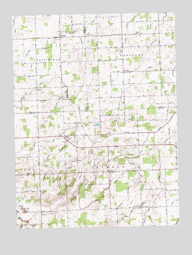
Domestic, IN USGS Topographic Map
Click on map above to begin viewing in our Map Viewer.

This topographic map contains these locations and features:
Feature Name Type Latitude Longitude GNIS ID View Map
Alberson CemeteryCemeteryN40.6125°W85.0689°430042View Map
Anderson DitchCanalN40.6239°W85.0191°430161View Map
Bourne Williams DitchCanalN40.5442°W85.0919°431383View Map
Brown CemeteryCemeteryN40.6028°W85.0414°431596View Map
Camp RunStreamN40.5498°W85.0630°432064View Map
Crampton DitchCanalN40.5184°W85.0394°433083View Map
DomesticPopulated PlaceN40.6117°W85.0886°433621View Map
Downing DitchCanalN40.5320°W85.0311°433676View Map
Egley DitchCanalN40.6145°W85.0369°434044View Map
Glendenning DitchCanalN40.5914°W85.0019°435114View Map
Hartford CemeteryCemeteryN40.5931°W85.0216°435825View Map
Haskin RunStreamN40.5614°W85.0744°435862View Map
Hunt DitchCanalN40.5387°W85.0816°436616View Map
Loew LakeReservoirN40.5550°W85.1116°448393View Map
McAllister DitchCanalN40.5745°W85.0908°438777View Map
Myers West DitchCanalN40.5120°W85.0339°439921View Map
Oakland ChurchChurchN40.5534°W85.0866°440467View Map
PerryvillePopulated PlaceN40.5912°W85.0405°441035View Map
PhenixPopulated PlaceN40.5820°W85.1072°441076View Map
PolingPopulated PlaceN40.5325°W85.0533°441405View Map
Powell DitchCanalN40.5289°W85.0450°441517View Map
Rankin Lewis DitchCanalN40.5634°W85.0994°441768View Map
Roth DitchCanalN40.5717°W85.0094°442334View Map
Rupel DitchCanalN40.5659°W85.0447°442391View Map
Schott DitchCanalN40.5931°W85.1116°443110View Map
Shirk Votaw DitchCanalN40.5342°W85.0741°443418View Map
Shoemaker DitchCanalN40.6042°W85.0719°443438View Map
Thomas DitchCanalN40.5170°W85.1208°444690View Map
Township of HartfordCivilN40.6124°W85.0315°453402View Map
Township of JacksonCivilN40.5250°W85.0486°453452View Map
Twin HillsSummitN40.5106°W85.1186°445012View Map
Union ChapelChurchN40.5117°W85.0286°445075View Map
Union ChapelChurchN40.5978°W85.0597°445076View Map
Vandorn DitchCanalN40.5337°W85.0655°445227View Map
Votaw DitchCanalN40.5373°W85.0547°445321View Map
Weaver DitchCanalN40.5145°W85.0033°445602View Map
West Grove CemeteryCemeteryN40.5317°W85.1164°445769View Map
White Oak ChurchChurchN40.5623°W85.0341°445950View Map
Wolf CreekStreamN40.5548°W85.0175°446234View Map

Note: Coordinates in the location and feature list above are referenced to NAD83 datum.


Copyright (C) 2008-2024 Ryan Niemi / Sunset Dynamics ... All Rights Reserved