TopoQuest Logo
Do you find TopoQuest useful?
Help keep TopoQuest running and adding new maps/features by donating!
Bitcoin:  19c7KJd3qBynnjoSw5npx9KScwjBe4ifkT
Litecoin:  LXs6TkuXGGXo1vDsWCkWVdjQX94eUKd6ui
Home View Maps Find Maps Find Places Resources & Links


Dodson Branch, Tennessee Topographic Map

USGS Map Title: Dodson Branch, TN
USGS Map MRC: 36085C5
DRG (GeoTIFF) Download: o36085c5.tif


Neighboring USGS Topographic Map Quads:


  Whitleyville, TN  
36085D6
 

  Burristown, TN  
36085D5
 

  Hilham, TN  
36085D4
 

  Gainesboro, TN  
36085C6
 

  Dodson Branch, TN  
36085C5
 

  Windle, TN  
36085C4
 

  Baxter, TN  
36085B6
 

  Cookeville West, TN  
36085B5
 

  Cookeville East, TN  
36085B4


Map MRC Location:

N37°
W86°
N37°
W85°
H8 H7 H6 H5 H4 H3 H2 H1
G8 G7 G6 G5 G4 G3 G2 G1
F8 F7 F6 F5 F4 F3 F2 F1
E8 E7 E6 E5 E4 E3 E2 E1
D8 D7 D6 D5 D4 D3 D2 D1
C8 C7 C6 C5 C4 C3 C2 C1
B8 B7 B6 B5 B4 B3 B2 B1
A8 A7 A6 A5 A4 A3 A2 A1
N36°
W86°
N36°
W85°

Dodson Branch, TN USGS 1:24K Topographic Map Preview:
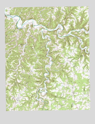
Dodson Branch, TN USGS Topographic Map
Click on map above to begin viewing in our Map Viewer.

This topographic map contains these locations and features:
Feature Name Type Latitude Longitude GNIS ID View Map
Aaron BranchStreamN36.3523°W85.6066°1304754View Map
Arbor ChurchChurchN36.3470°W85.5236°1304865View Map
Arbor School (historical)SchoolN36.3470°W85.5236°1320737View Map
Backbone RidgeRidgeN36.3062°W85.6175°1276060View Map
Big Jessie HollowValleyN36.3281°W85.5645°1277335View Map
Birdwell CemeteryCemeteryN36.2659°W85.6130°1277519View Map
Blackburn ForkStreamN36.3476°W85.5619°1305269View Map
Blackburn Fork State Scenic RiverParkN36.2809°W85.5653°1325362View Map
Booger HillSummitN36.3689°W85.5378°1277961View Map
Bowman BranchStreamN36.2703°W85.5780°1278068View Map
Burroughs HollowValleyN36.3181°W85.5615°1279118View Map
Cedar Grove School (historical)SchoolN36.3656°W85.6080°1320745View Map
Center GrovePopulated PlaceN36.2639°W85.6086°1280124View Map
Center Grove School (historical)SchoolN36.2656°W85.6130°1320746View Map
Chaffin CemeteryCemeteryN36.2964°W85.5983°1280194View Map
Chaney CemeteryCemeteryN36.2703°W85.5936°1647565View Map
Commissioner District 3CivilN36.3135°W85.5595°2464161View Map
Commissioner District 4CivilN36.2591°W85.5725°2464052View Map
Cubelow HollowValleyN36.2854°W85.6097°1281801View Map
Cummins Mill (historical)LocaleN36.2506°W85.5647°1320750View Map
Dave BluffCliffN36.3128°W85.5058°1282082View Map
Dodson BranchStreamN36.3237°W85.5122°1306358View Map
Dodson BranchPopulated PlaceN36.3126°W85.5322°1314954View Map
Dodson Branch Census Designated PlaceCensusN36.3149°W85.5322°2586048View Map
Dodson Branch ChurchChurchN36.3028°W85.5233°1306359View Map
Dodson Branch SchoolSchoolN36.3087°W85.5289°1306360View Map
Dodson Branch Volunteer Fire Department Station 1BuildingN36.2779°W85.5275°2654999View Map
Dodson Branch Volunteer Fire Department Station 2BuildingN36.3083°W85.5303°2654835View Map
Dry CreekStreamN36.2728°W85.5630°1282942View Map
Dry Creek FallsFallsN36.2664°W85.5514°1282951View Map
Engia HollowValleyN36.3308°W85.5633°1283781View Map
FreewillPopulated PlaceN36.2976°W85.5858°1315081View Map
Freewill ChurchChurchN36.2973°W85.5864°1320759View Map
Freewill RidgeRidgeN36.3206°W85.5797°1284900View Map
Freewill School (historical)SchoolN36.2970°W85.5869°1320760View Map
Gainesboro Division (historical)CensusN36.3226°W85.6150°1648792View Map
Gaw BranchStreamN36.3528°W85.5764°1285258View Map
Gentry CemeteryCemeteryN36.3289°W85.5964°1285281View Map
Gentry School (historical)SchoolN36.3159°W85.5622°1320764View Map
Hammock HollowValleyN36.2899°W85.5658°1286680View Map
Hardscrabble BluffCliffN36.3145°W85.5133°1286851View Map
Hardscrabble HollowValleyN36.3132°W85.5169°1286852View Map
Hardscrabble PinnaclePillarN36.3151°W85.5136°1286853View Map
Hardy HollowValleyN36.3055°W85.5045°1286858View Map
Hensley CemeteryCemeteryN36.3031°W85.5847°1287460View Map
Hopper CreekStreamN36.3537°W85.5416°1288337View Map
Hurricane HollowValleyN36.3414°W85.5892°1288828View Map
Judd HollowValleyN36.2868°W85.5617°1289868View Map
Lankford HollowValleyN36.3077°W85.5552°1290627View Map
Long BranchStreamN36.3645°W85.6047°1291909View Map
Lynn School (historical)SchoolN36.2837°W85.5666°1320784View Map
Maberry SchoolSchoolN36.2767°W85.5353°1292390View Map
Martin RidgeRidgeN36.2903°W85.6183°1647572View Map
Masters Mill (historical)LocaleN36.3353°W85.5575°1320786View Map
Mayfield (historical)Populated PlaceN36.2814°W85.6219°1312009View Map
Morrison CreekPopulated PlaceN36.3306°W85.5944°1315538View Map
Morrison CreekStreamN36.3573°W85.5911°1294451View Map
Morrison Creek School (historical)SchoolN36.3301°W85.5950°1320788View Map
Mount UnionPopulated PlaceN36.2703°W85.5253°1294813View Map
Mount Union ChurchChurchN36.2714°W85.5253°1320789View Map
Nancy Miles HollowValleyN36.3211°W85.5617°1295224View Map
Overton CemeteryCemeteryN36.3520°W85.5439°1296549View Map
Pacific (historical)Populated PlaceN36.3539°W85.5791°1312016View Map
Peaks Mill (historical)LocaleN36.3212°W85.5069°1320799View Map
Pendleton BluffCliffN36.3153°W85.5147°1297142View Map
Petty HollowValleyN36.2997°W85.6092°1297281View Map
Pine Hill School (historical)SchoolN36.2512°W85.5566°1320802View Map
Poke Mansell HollowValleyN36.3153°W85.5640°1298016View Map
Pole Bridge BranchStreamN36.3206°W85.5105°1298026View Map
Roaring River Mill (historical)LocaleN36.3642°W85.6044°1320804View Map
Roaring River State Scenic RiverParkN36.3517°W85.5658°1325363View Map
Roberts HollowValleyN36.3041°W85.5582°1299645View Map
Ruff HollowValleyN36.3062°W85.6042°1300239View Map
Sara Lee HollowValleyN36.3381°W85.5379°1300787View Map
Scott HollowValleyN36.3585°W85.5994°1647577View Map
Seth HollowValleyN36.3344°W85.5573°1301087View Map
Seven KnobsSummitN36.2853°W85.5908°1301096View Map
Smith ChapelChurchN36.2687°W85.5039°1270661View Map
South Side Volunteer Fire DepartmentBuildingN36.2647°W85.6088°2654825View Map
Spring CreekStreamN36.3414°W85.5286°1271088View Map
Spring Creek ChurchChurchN36.2667°W85.5233°1271095View Map
Stafford CemeteryCemeteryN36.3584°W85.6075°1271189View Map
Steprock HillSummitN36.3264°W85.5089°1312024View Map
Stony Point School (historical)SchoolN36.3470°W85.5730°1320811View Map
Sugartown RidgeRidgeN36.3178°W85.6191°1271728View Map
Talley CreekStreamN36.3492°W85.6044°1272058View Map
Talley HollowValleyN36.3490°W85.6043°1647580View Map
Tater KnobSummitN36.3217°W85.5083°1272166View Map
The BoilsSpringN36.3501°W85.5628°1272373View Map
Tom Allen HollowValleyN36.3010°W85.5668°1272738View Map
Tom HollowValleyN36.2959°W85.6064°1272744View Map
Twelve Corners CemeteryCemeteryN36.2845°W85.5261°1273112View Map
Twelve Corners Church (historical)ChurchN36.2798°W85.5239°1320814View Map
Twelve Corners HollowValleyN36.2664°W85.5524°1273113View Map
Wash Morgan HollowValleyN36.3394°W85.5325°1273854View Map
Whiteacres Mill (historical)LocaleN36.3448°W85.5150°1320817View Map
Whitehall School (historical)SchoolN36.2548°W85.5050°1317856View Map
Woodrow School (historical)SchoolN36.3667°W85.6172°1320821View Map
Young CemeteryCemeteryN36.2653°W85.6072°1275326View Map
Zion ChurchChurchN36.2823°W85.5411°1304726View Map

Note: Coordinates in the location and feature list above are referenced to NAD83 datum.


Copyright (C) 2008-2024 Ryan Niemi / Sunset Dynamics ... All Rights Reserved