TopoQuest Logo
Do you find TopoQuest useful?
Help keep TopoQuest running and adding new maps/features by donating!
Bitcoin:  19c7KJd3qBynnjoSw5npx9KScwjBe4ifkT
Litecoin:  LXs6TkuXGGXo1vDsWCkWVdjQX94eUKd6ui
Home View Maps Find Maps Find Places Resources & Links


Depue, Illinois Topographic Map

USGS Map Title: Depue, IL
USGS Map MRC: 41089C3
DRG (GeoTIFF) Download: o41089c3.tif


Neighboring USGS Topographic Map Quads:


  Princeton North, IL  
41089D4
 

  Malden, IL  
41089D3
 

  Ladd, IL  
41089D2
 

  Princeton South, IL  
41089C4
 

  Depue, IL  
41089C3
 

  Spring Valley, IL  
41089C2
 

  Putnam, IL  
41089B4
 

  Florid, IL  
41089B3
 

  McNabb, IL  
41089B2


Map MRC Location:

N42°
W90°
N42°
W89°
H8 H7 H6 H5 H4 H3 H2 H1
G8 G7 G6 G5 G4 G3 G2 G1
F8 F7 F6 F5 F4 F3 F2 F1
E8 E7 E6 E5 E4 E3 E2 E1
D8 D7 D6 D5 D4 D3 D2 D1
C8 C7 C6 C5 C4 C3 C2 C1
B8 B7 B6 B5 B4 B3 B2 B1
A8 A7 A6 A5 A4 A3 A2 A1
N41°
W90°
N41°
W89°

Depue, IL USGS 1:24K Topographic Map Preview:
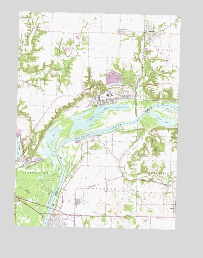
Depue, IL USGS Topographic Map
Click on map above to begin viewing in our Map Viewer.

This topographic map contains these locations and features:
Feature Name Type Latitude Longitude GNIS ID View Map
Allforks CreekStreamN41.3150°W89.2784°403439View Map
Artestian Well CemeteryCemeteryN41.3678°W89.3117°1958608View Map
BureauPopulated PlaceN41.2892°W89.3665°405211View Map
Bureau Fire Protection DistrictBuildingN41.2888°W89.3669°2640719View Map
Bureau Post OfficePost OfficeN41.2880°W89.3661°2788708View Map
Clark IslandIslandN41.3203°W89.2568°406160View Map
Coal HollowPopulated PlaceN41.3656°W89.3634°422565View Map
Coleman LakeLakeN41.2901°W89.3332°406353View Map
De Pue Police DepartmentBuildingN41.3219°W89.3099°2757149View Map
De Pue Village CemeteryCemeteryN41.3406°W89.3179°407139View Map
DepuePopulated PlaceN41.3242°W89.3068°407138View Map
Depue Elementary SchoolSchoolN41.3223°W89.3070°1822645View Map
Depue Fire DepartmentBuildingN41.3249°W89.3105°2640168View Map
Depue High SchoolSchoolN41.3228°W89.3070°1822646View Map
Depue LakeLakeN41.3152°W89.3146°407140View Map
Depue Post OfficePost OfficeN41.3244°W89.3081°2788208View Map
Donnelley State Fish and Wildlife AreaParkN41.2903°W89.3326°1820609View Map
Evangelical and Reformed CemeteryCemeteryN41.3643°W89.2941°1822648View Map
First Congregational ChurchChurchN41.3231°W89.3079°1967947View Map
First Congregational Church of BureauChurchN41.2892°W89.3670°1967949View Map
Foley AirportAirportN41.3743°W89.3484°427710View Map
Granville - Hennepin Fire Protection DistrictBuildingN41.2539°W89.3451°2640857View Map
Greenwood CemeteryCemeteryN41.2995°W89.3643°409463View Map
HennepinPopulated PlaceN41.2542°W89.3423°410059View Map
Hennepin Post OfficePost OfficeN41.2531°W89.3443°2788242View Map
Hennepin Power StationBuildingN41.3031°W89.3150°2419857View Map
Hennepin United Methodist ChurchChurchN41.2539°W89.3415°1967961View Map
Hickory Ridge LakeLakeN41.2670°W89.3475°410178View Map
HollowayvillePopulated PlaceN41.3650°W89.2970°410403View Map
Hollowayville CemeteryCemeteryN41.3642°W89.2937°1958661View Map
Hollowayville United Church of ChristChurchN41.3639°W89.2948°1822662View Map
Hormel PondsReservoirN41.2883°W89.3586°1822664View Map
Lake Depue State Fish and Wildlife AreaParkN41.3103°W89.3287°1822678View Map
Lake ParkParkN41.3217°W89.3112°411728View Map
Lake RawsonLakeN41.2946°W89.3746°416422View Map
Leepertown Elementary SchoolSchoolN41.2886°W89.3701°1822680View Map
Leepertown Township Public LibraryBuildingN41.2898°W89.3679°1822681View Map
Lost LakeLakeN41.2828°W89.3419°412661View Map
Lower Spring LakeReservoirN41.2921°W89.3473°412722View Map
Lyons LakeLakeN41.3073°W89.2947°412782View Map
MarkPopulated PlaceN41.2645°W89.2501°413008View Map
Mark Post OfficePost OfficeN41.2647°W89.2505°2788549View Map
MarquettePopulated PlaceN41.3309°W89.2626°422943View Map
Maulfair Airport (historical)AirportN41.2528°W89.2723°427338View Map
MorontsPopulated PlaceN41.2861°W89.2945°422999View Map
Myer Woods Nature PreserveParkN41.3514°W89.3459°2013867View Map
Negro CreekStreamN41.3211°W89.2720°414340View Map
North Gypsum PondReservoirN41.3334°W89.2934°1692507View Map
North Gypsum Pond DamDamN41.3334°W89.2934°1692506View Map
Old Channel Big Bureau CreekStreamN41.2781°W89.3404°415001View Map
OttvillePopulated PlaceN41.3481°W89.2587°415240View Map
Putnam County CourthouseBuildingN41.2534°W89.3426°1820613View Map
Putnam County Farm (historical)LocaleN41.2600°W89.2812°1720220View Map
Putnam County Sheriff's OfficeBuildingN41.2533°W89.3425°2756886View Map
Putnam Emergency Medical ServicesBuildingN41.2538°W89.3453°2673872View Map
Ridge School (historical)SchoolN41.3317°W89.3684°1721013View Map
Saint John Evangelical Lutheran ChurchChurchN41.3673°W89.3120°417349View Map
Saint Johns Lutheran CemeteryCemeteryN41.3678°W89.3120°1820584View Map
Saint Marys Catholic ChurchChurchN41.3231°W89.3015°1967948View Map
Searl Ridge CemeteryCemeteryN41.3328°W89.3679°418165View Map
SeatonvillePopulated PlaceN41.3648°W89.2765°418172View Map
Seatonville Fire Protection DistrictBuildingN41.3649°W89.2766°2640351View Map
Seatonville Post OfficePost OfficeN41.3643°W89.2763°2788540View Map
Spring LakeReservoirN41.3023°W89.3468°418977View Map
Township of LeepertownCivilN41.2851°W89.3593°429243View Map
Township of SelbyCivilN41.3642°W89.3353°429727View Map
Turner LakeLakeN41.3138°W89.2588°419954View Map
Village of Bureau JunctionCivilN41.2877°W89.3642°2397497View Map
Village of De PueCivilN41.3275°W89.2963°2398694View Map
Village of HollowayvilleCivilN41.3648°W89.2949°2398528View Map
Village of MarkCivilN41.2623°W89.2553°2399259View Map
Village of SeatonvilleCivilN41.3647°W89.2741°2399780View Map
White City ParkParkN41.3292°W89.2915°421032View Map
Windblown Bottoms Duck Club (historical)LocaleN41.2875°W89.3315°1820617View Map
Wolf HollowValleyN41.3047°W89.2733°421388View Map

Note: Coordinates in the location and feature list above are referenced to NAD83 datum.


Copyright (C) 2008-2024 Ryan Niemi / Sunset Dynamics ... All Rights Reserved