TopoQuest Logo
Do you find TopoQuest useful?
Help keep TopoQuest running and adding new maps/features by donating!
Bitcoin:  19c7KJd3qBynnjoSw5npx9KScwjBe4ifkT
Litecoin:  LXs6TkuXGGXo1vDsWCkWVdjQX94eUKd6ui
Home View Maps Find Maps Find Places Resources & Links


Democrat Hot Springs, California Topographic Map

USGS Map Title: Democrat Hot Springs, CA
USGS Map MRC: 35118E6
DRG (GeoTIFF) Download: o35118e6.tif


Neighboring USGS Topographic Map Quads:


  Woody, CA  
35118F7
 

  Glennville, CA  
35118F6
 

  Alta Sierra, CA  
35118F5
 

  Pine Mountain, CA  
35118E7
 

  Democrat Hot Springs, CA  
35118E6
 

  Miracle Hot Springs, CA  
35118E5
 

  Rio Bravo Ranch, CA  
35118D7
 

  Mount Adelaide, CA  
35118D6
 

  Breckenridge Mountain, CA  
35118D5


Map MRC Location:

N36°
W119°
N36°
W118°
H8 H7 H6 H5 H4 H3 H2 H1
G8 G7 G6 G5 G4 G3 G2 G1
F8 F7 F6 F5 F4 F3 F2 F1
E8 E7 E6 E5 E4 E3 E2 E1
D8 D7 D6 D5 D4 D3 D2 D1
C8 C7 C6 C5 C4 C3 C2 C1
B8 B7 B6 B5 B4 B3 B2 B1
A8 A7 A6 A5 A4 A3 A2 A1
N35°
W119°
N35°
W118°

Democrat Hot Springs, CA USGS 1:24K Topographic Map Preview:
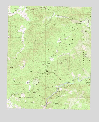
Democrat Hot Springs, CA USGS Topographic Map
Click on map above to begin viewing in our Map Viewer.

This topographic map contains these locations and features:
Feature Name Type Latitude Longitude GNIS ID View Map
Badger GapGapN35.5461°W118.6929°269625View Map
Ball MountainSummitN35.5583°W118.7087°238937View Map
Big Tenant SpringSpringN35.5600°W118.6621°269854View Map
Burke CreekStreamN35.6144°W118.7331°1670216View Map
Burke HillSummitN35.6169°W118.6984°1656444View Map
Callioud SpringSpringN35.5996°W118.6554°270167View Map
Canary SpringSpringN35.5537°W118.6962°270271View Map
Caughran SpringSpringN35.5552°W118.6909°270355View Map
China GardenFlatN35.5361°W118.6448°270431View Map
Coffee CreekStreamN35.6150°W118.6834°270525View Map
Cold SpringSpringN35.5991°W118.6481°270539View Map
Cow Flat CreekStreamN35.5005°W118.6940°270645View Map
Democrat Fire StationLocaleN35.5305°W118.6306°275602View Map
Democrat Guard Station (historical)LocaleN35.5319°W118.6290°1670219View Map
Democrat Hot SpringsLocaleN35.5280°W118.6679°270835View Map
Democrat SpringSpringN35.5068°W118.6790°270836View Map
Diversion Number 1 104-002 DamDamN35.5250°W118.6743°1663694View Map
French RanchLocaleN35.5827°W118.6734°271234View Map
French Ranch GulchValleyN35.5797°W118.7101°271235View Map
Greenhorn School (historical)SchoolN35.5719°W118.6765°1835867View Map
Hog Hole SpringSpringN35.5670°W118.6344°271596View Map
Little Poso CreekStreamN35.5725°W118.7284°272109View Map
Little Tenant SpringSpringN35.5560°W118.6690°272132View Map
Mike Harney CanyonValleyN35.5797°W118.6718°272455View Map
Mormon CanyonValleyN35.6180°W118.7301°272558View Map
Oak FlatFlatN35.5319°W118.7187°272732View Map
Oak Flat LookoutLocaleN35.5352°W118.7076°272738View Map
Oscar Meyer SpringSpringN35.5157°W118.6717°272816View Map
Poso FlatFlatN35.6216°W118.7445°273090View Map
Prefedio CreekStreamN35.5297°W118.6665°273119View Map
Prefedio SpringSpringN35.5462°W118.6811°273120View Map
Saturday PeakSummitN35.5072°W118.7234°273584View Map
Saturday SpringSpringN35.5077°W118.7143°273585View Map
Saturday Spring CreekStreamN35.5127°W118.6912°273583View Map
Smith RanchLocaleN35.5702°W118.6762°275601View Map
Tenant CreekStreamN35.5325°W118.6565°274065View Map
Tucker CreekStreamN35.5391°W118.6293°274205View Map
Willow SpringSpringN35.5207°W118.7091°274529View Map
Willow Spring CreekStreamN35.5258°W118.6756°274532View Map

Note: Coordinates in the location and feature list above are referenced to NAD83 datum.


Copyright (C) 2008-2024 Ryan Niemi / Sunset Dynamics ... All Rights Reserved