TopoQuest Logo
Do you find TopoQuest useful?
Help keep TopoQuest running and adding new maps/features by donating!
Bitcoin:  19c7KJd3qBynnjoSw5npx9KScwjBe4ifkT
Litecoin:  LXs6TkuXGGXo1vDsWCkWVdjQX94eUKd6ui
Home View Maps Find Maps Find Places Resources & Links


Democrat, Texas Topographic Map

USGS Map Title: Democrat, TX
USGS Map MRC: 31098F6
DRG (GeoTIFF) Download: o31098f6.tif


Neighboring USGS Topographic Map Quads:


  Blanket, TX  
31098G7
 

  Mercers Gap, TX  
31098G6
 

  Newburg, TX  
31098G5
 

  Zephyr, TX  
31098F7
 

  Democrat, TX  
31098F6
 

  Priddy, TX  
31098F5
 

  Blanket Springs, TX  
31098E7
 

  Mullin, TX  
31098E6
 

  Lake Merritt, TX  
31098E5


Map MRC Location:

N32°
W99°
N32°
W98°
H8 H7 H6 H5 H4 H3 H2 H1
G8 G7 G6 G5 G4 G3 G2 G1
F8 F7 F6 F5 F4 F3 F2 F1
E8 E7 E6 E5 E4 E3 E2 E1
D8 D7 D6 D5 D4 D3 D2 D1
C8 C7 C6 C5 C4 C3 C2 C1
B8 B7 B6 B5 B4 B3 B2 B1
A8 A7 A6 A5 A4 A3 A2 A1
N31°
W99°
N31°
W98°

Democrat, TX USGS 1:24K Topographic Map Preview:
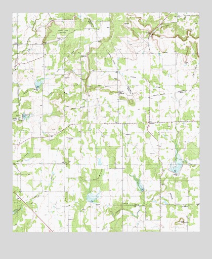
Democrat, TX USGS Topographic Map
Click on map above to begin viewing in our Map Viewer.

This topographic map contains these locations and features:
Feature Name Type Latitude Longitude GNIS ID View Map
Aldridge LakeReservoirN31.6419°W98.6506°1860789View Map
Aldridge Lake DamDamN31.6418°W98.6503°1860788View Map
Beards GapGapN31.7043°W98.6789°1330258View Map
Bethel ChurchChurchN31.7321°W98.7470°1330490View Map
Blanket Creek Watershed Number 16ReservoirN31.6911°W98.7424°1384294View Map
Blanket Creek Watershed Number FifteenReservoirN31.7090°W98.7333°1330844View Map
Blanket Creek Watershed Reservoir Number EighteenReservoirN31.6502°W98.6645°1330848View Map
Blanket Creek Watershed Reservoir Number NineteenReservoirN31.6435°W98.6980°1330849View Map
Brushy GapGapN31.7382°W98.6567°1331443View Map
Carlisle AirportAirportN31.6819°W98.6621°2675877View Map
DemocratPopulated PlaceN31.6874°W98.6587°1334249View Map
Democrat CemeteryCemeteryN31.6871°W98.6537°1334250View Map
Dudley CemeteryCemeteryN31.6877°W98.6534°1334722View Map
Lethco LakeReservoirN31.6452°W98.6570°1864016View Map
Lethco Lake DamDamN31.6452°W98.6570°1864015View Map
Long Pompey MountainSummitN31.6310°W98.6381°1340505View Map
Meyer LakeReservoirN31.6651°W98.6920°1860792View Map
Meyer Lake DamDamN31.6635°W98.6920°1860791View Map
Soil Conservation Service Site 15 DamDamN31.7068°W98.7353°1859679View Map
Soil Conservation Service Site 16 DamDamN31.6918°W98.7453°1862761View Map
Soil Conservation Service Site 16 ReservoirReservoirN31.6918°W98.7453°1862762View Map
Soil Conservation Service Site 17a-1 DamDamN31.6618°W98.6403°1860780View Map
Soil Conservation Service Site 17a-1 ReservoirReservoirN31.6610°W98.6406°1860781View Map
Soil Conservation Service Site 18 DamDamN31.6468°W98.6637°1860782View Map
Soil Conservation Service Site 18 ReservoirReservoirN31.6471°W98.6632°1860783View Map
Soil Conservation Service Site 19 DamDamN31.6402°W98.6970°1860784View Map
Soil Conservation Service Site 19 ReservoirReservoirN31.6407°W98.6980°1860785View Map
Spur MountainSummitN31.7074°W98.6834°1347769View Map
Turkey Peak MountainSummitN31.7390°W98.7142°1348890View Map

Note: Coordinates in the location and feature list above are referenced to NAD83 datum.


Copyright (C) 2008-2024 Ryan Niemi / Sunset Dynamics ... All Rights Reserved