TopoQuest Logo
Do you find TopoQuest useful?
Help keep TopoQuest running and adding new maps/features by donating!
Bitcoin:  19c7KJd3qBynnjoSw5npx9KScwjBe4ifkT
Litecoin:  LXs6TkuXGGXo1vDsWCkWVdjQX94eUKd6ui
Home View Maps Find Maps Find Places Resources & Links


Deltaville, Virginia Topographic Map

USGS Map Title: Deltaville, VA
USGS Map MRC: 37076E3
DRG (GeoTIFF) Download: o37076e3.tif


Neighboring USGS Topographic Map Quads:


  Irvington, VA  
37076F4
 

  Fleets Bay, VA  
37076F3
 

  East of Fleets Bay, VA  
37076F2
 

  Wilton, VA  
37076E4
 

  Deltaville, VA  
37076E3
 

  East of Deltaville, VA  
37076E2
 

  Ware Neck, VA  
37076D4
 

  Mathews, VA  
37076D3
 

  Bethel Beach, VA  
37076D2


Map MRC Location:

N38°
W77°
N38°
W76°
H8 H7 H6 H5 H4 H3 H2 H1
G8 G7 G6 G5 G4 G3 G2 G1
F8 F7 F6 F5 F4 F3 F2 F1
E8 E7 E6 E5 E4 E3 E2 E1
D8 D7 D6 D5 D4 D3 D2 D1
C8 C7 C6 C5 C4 C3 C2 C1
B8 B7 B6 B5 B4 B3 B2 B1
A8 A7 A6 A5 A4 A3 A2 A1
N37°
W77°
N37°
W76°

Deltaville, VA USGS 1:24K Topographic Map Preview:
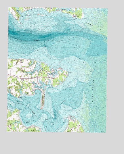
Deltaville, VA USGS Topographic Map
Click on map above to begin viewing in our Map Viewer.

This topographic map contains these locations and features:
Feature Name Type Latitude Longitude GNIS ID View Map
AmburgPopulated PlaceN37.5537°W76.3583°1462437View Map
Bland PointCapeN37.5343°W76.3616°1463554View Map
Broad CreekStreamN37.5621°W76.3144°1463840View Map
Burton PointCapeN37.5035°W76.3349°1464151View Map
Chapel CreekStreamN37.5104°W76.3577°1464740View Map
Cherry PointCapeN37.5151°W76.2977°1464783View Map
Chesapeake Cove MarinaLocaleN37.5579°W76.3147°1739482View Map
Clarksburg ChurchChurchN37.5546°W76.3627°1464950View Map
Club on Fishing Bay MarinaLocaleN37.5410°W76.3405°1739484View Map
Cores CreekStreamN37.5385°W76.3722°1465249View Map
Deep Hole PointCapeN37.6171°W76.3294°1465705View Map
DeltavillePopulated PlaceN37.5549°W76.3369°1492861View Map
Deltaville Census Designated PlaceCensusN37.5509°W76.3293°2630705View Map
Deltaville MarinaHarborN37.5499°W76.3302°2520096View Map
Deltaville Post OfficePost OfficeN37.5556°W76.3387°2767206View Map
Fishing BayBayN37.5351°W76.3377°1466609View Map
Fishing Bay Harbor MarinaHarborN37.5410°W76.3398°2518562View Map
Fishing PointCapeN37.5387°W76.3399°1466617View Map
Fleets IslandIslandN37.6212°W76.2888°1466689View Map
Georges CoveBayN37.6215°W76.2902°1779069View Map
Godfrey BayBayN37.5099°W76.3491°1467181View Map
Godfrey Bay Public RampLocaleN37.5058°W76.3540°2520077View Map
GrimsteadPopulated PlaceN37.5004°W76.3013°1493042View Map
Grimstead Post OfficePost OfficeN37.5001°W76.3011°2767220View Map
GrinelsPopulated PlaceN37.5699°W76.3583°1477376View Map
Grinels WharfLocaleN37.5404°W76.3405°1478025View Map
GwynnPopulated PlaceN37.5043°W76.2886°1467619View Map
Gwynn IslandIslandN37.5074°W76.2902°1467620View Map
Gwynn Post OfficePost OfficeN37.5034°W76.2855°2767221View Map
Gwynns Island CemeteryCemeteryN37.5004°W76.2944°1739096View Map
HardyvillePopulated PlaceN37.5568°W76.3719°1467746View Map
Hunting CreekStreamN37.5715°W76.3433°1468397View Map
Iron PointCapeN37.5215°W76.3594°1468517View Map
Jackson CreekStreamN37.5460°W76.3269°1468598View Map
Jackson Creek WharfLocaleN37.5482°W76.3233°1739493View Map
Kibble PondLakeN37.5140°W76.2927°1468988View Map
Little Oyster CreekStreamN37.6240°W76.3063°1469611View Map
Lower Middlesex Volunteer Fire DepartmentBuildingN37.5538°W76.3457°2331722View Map
Mathews Volunteer Fire Department Station 3BuildingN37.5043°W76.2881°2331675View Map
Middlesex County Volunteer Rescue SquadBuildingN37.5544°W76.3313°2331632View Map
Moore CreekStreamN37.5374°W76.3572°1470708View Map
Mosquito CreekStreamN37.6112°W76.3566°1470780View Map
Mosquito IslandIslandN37.6165°W76.3508°1470781View Map
Mosquito PointCapeN37.6090°W76.3597°1470782View Map
North End Wharf (historical)LocaleN37.5740°W76.3594°1739500View Map
Norview MarinaHarborN37.5577°W76.3137°2520081View Map
Norviews LandingLocaleN37.5626°W76.3172°1739501View Map
PalmerPopulated PlaceN37.6237°W76.3513°1493389View Map
Philippi ChurchChurchN37.5546°W76.3386°1472252View Map
Piankatank Landing Boat RampLocaleN37.5058°W76.3540°2518548View Map
Piankatank RiverStreamN37.5360°W76.2958°1472267View Map
Piankatank River LandingLocaleN37.5057°W76.3541°1739133View Map
Pine Top DistrictCivilN37.5598°W76.3354°1927445View Map
Rappahanncock SpitBarN37.6076°W76.2674°1480192View Map
Rappahannock RiverStreamN37.5876°W76.2891°1479404View Map
RuarkPopulated PlaceN37.5443°W76.3419°1493512View Map
Sandy Bottom (historical)Populated PlaceN37.5546°W76.3186°1782069View Map
Shiloh ChurchChurchN37.5051°W76.2916°1474512View Map
Ships HoleBasinN37.6137°W76.3580°1779088View Map
Stingray PointLocaleN37.5612°W76.2702°1480193View Map
Stingray PointCapeN37.5601°W76.2986°1475159View Map
Stingray PointPopulated PlaceN37.5587°W76.3052°1475160View Map
Stingray Point MarinaHarborN37.5607°W76.3067°2518578View Map
Stingray Point Post Office (historical)Post OfficeN37.5587°W76.3052°1926780View Map
Stove PointCapeN37.5229°W76.3327°1475228View Map
Stove Point NeckCapeN37.5346°W76.3297°1475230View Map
Sturgeon CreekStreamN37.5696°W76.3349°1475269View Map
Timber NeckCapeN37.5612°W76.3266°1475722View Map
Waldens MarinaHarborN37.5602°W76.3159°2518580View Map
Walters MarinaHarborN37.5586°W76.3214°2518581View Map
Warehouse CoveBayN37.5210°W76.3691°1476330View Map
WestlandPopulated PlaceN37.6171°W76.2927°1493782View Map
White MarshSwampN37.6236°W76.2862°1476593View Map
Windjammer Golf CourseLocaleN37.6157°W76.2845°2520208View Map
Windmill PointCapeN37.6137°W76.2797°1476850View Map
Windmill Point Boat RampLocaleN37.6152°W76.2938°2518559View Map
Windmill Point CreekStreamN37.6215°W76.3077°1476851View Map
Windmill Point LandingLocaleN37.6154°W76.2938°1779098View Map
Windmill Point Yacht HarborHarborN37.6155°W76.2904°2518582View Map
Zoar ChurchChurchN37.5543°W76.3419°1474430View Map

Note: Coordinates in the location and feature list above are referenced to NAD83 datum.


Copyright (C) 2008-2024 Ryan Niemi / Sunset Dynamics ... All Rights Reserved