TopoQuest Logo
Do you find TopoQuest useful?
Help keep TopoQuest running and adding new maps/features by donating!
Bitcoin:  19c7KJd3qBynnjoSw5npx9KScwjBe4ifkT
Litecoin:  LXs6TkuXGGXo1vDsWCkWVdjQX94eUKd6ui
Home View Maps Find Maps Find Places Resources & Links


Delmar, South Carolina Topographic Map

USGS Map Title: Delmar, SC
USGS Map MRC: 34081A5
DRG (GeoTIFF) Download: o34081a5.tif


Neighboring USGS Topographic Map Quads:


  Silverstreet, SC  
34081B6
 

  Prosperity, SC  
34081B5
 

  Little Mountain, SC  
34081B4
 

  Denny, SC  
34081A6
 

  Delmar, SC  
34081A5
 

  Lake Murray West, SC  
34081A4
 

  Emory, SC  
33081H6
 

  Batesburg, SC  
33081H5
 

  Gilbert, SC  
33081H4


Map MRC Location:

N35°
W82°
N35°
W81°
H8 H7 H6 H5 H4 H3 H2 H1
G8 G7 G6 G5 G4 G3 G2 G1
F8 F7 F6 F5 F4 F3 F2 F1
E8 E7 E6 E5 E4 E3 E2 E1
D8 D7 D6 D5 D4 D3 D2 D1
C8 C7 C6 C5 C4 C3 C2 C1
B8 B7 B6 B5 B4 B3 B2 B1
A8 A7 A6 A5 A4 A3 A2 A1
N34°
W82°
N34°
W81°

Delmar, SC USGS 1:24K Topographic Map Preview:
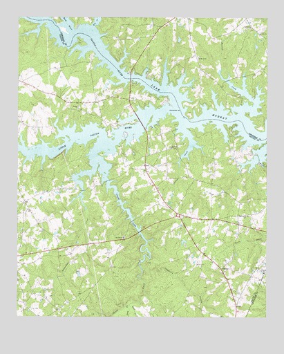
Delmar, SC USGS Topographic Map
Click on map above to begin viewing in our Map Viewer.

This topographic map contains these locations and features:
Feature Name Type Latitude Longitude GNIS ID View Map
Batesburg-Leesville DivisionCivilN34.0050°W81.5845°1938193View Map
Beaverdam CreekStreamN34.0440°W81.5912°1220444View Map
Bethel CemeteryCemeteryN34.1207°W81.5084°1228370View Map
Bethel ChurchChurchN34.1210°W81.5084°1246788View Map
Bethel Number 1 ChurchChurchN34.0426°W81.5101°1246805View Map
Big CreekStreamN34.1207°W81.5879°1220693View Map
Blacks BridgeBridgeN34.0996°W81.5684°1228376View Map
Booser Hill Church (historical)ChurchN34.0360°W81.6129°1232542View Map
Bush RiverStreamN34.1179°W81.5965°1229491View Map
Circle Fire Department Station 800BuildingN34.0430°W81.5425°2578492View Map
Clapboard BranchStreamN34.0210°W81.5623°1221604View Map
Clouds CreekStreamN34.0710°W81.5834°1221644View Map
Cool Spring School (historical)SchoolN34.0504°W81.6162°1232553View Map
Corinth (historical)Populated PlaceN34.0979°W81.6226°1232554View Map
DelmarPopulated PlaceN34.0201°W81.5223°1231220View Map
Delmar Community CenterBuildingN34.0201°W81.5257°1232558View Map
Delmar School (historical)SchoolN34.0204°W81.5234°1232559View Map
Fairview School (historical)SchoolN34.0096°W81.5937°1232571View Map
Halls PondReservoirN34.0319°W81.5411°1239067View Map
Halls Pond Dam D-1603DamN34.0318°W81.5415°1239066View Map
Hawleek CreekStreamN34.0854°W81.5143°1223089View Map
Holley School (historical)SchoolN34.0588°W81.5009°1232585View Map
Little Saluda RiverStreamN34.0854°W81.5470°1224048View Map
Long BranchStreamN34.0054°W81.5687°1224150View Map
Matthews CemeteryCemeteryN34.0087°W81.6087°1232590View Map
Matthews CemeteryCemeteryN34.0035°W81.6159°1232591View Map
Mission Church (historical)ChurchN34.0168°W81.5754°1232596View Map
Mount Hebron CemeteryCemeteryN34.0187°W81.5223°1232599View Map
Mount Hebron Lutheran ChurchChurchN34.0182°W81.5218°1232600View Map
Mount Moriah CemeteryCemeteryN34.1090°W81.5343°1228751View Map
Mount Moriah ChurchChurchN34.1085°W81.5345°1249603View Map
Mount Moriah School (historical)SchoolN34.1082°W81.5345°1228752View Map
Mount Olive ChurchChurchN34.1185°W81.5034°1249623View Map
Nazareth CemeteryCemeteryN34.0337°W81.5715°1232605View Map
Nazareth ChurchChurchN34.0326°W81.5715°1249772View Map
Newberry County Rural Fire Department O'NealBuildingN34.1121°W81.5363°2578840View Map
O'Neal CemeteryCemeteryN34.1187°W81.5029°1228779View Map
Oneal School (historical)SchoolN34.1210°W81.5068°1228786View Map
Philippi ChurchChurchN34.0868°W81.5945°1225399View Map
Philippi School (historical)SchoolN34.0565°W81.5579°1232612View Map
Pleasant Grove School (historical)SchoolN34.0621°W81.5609°1232616View Map
Saint Marks ChurchChurchN34.0710°W81.5476°1250597View Map
Spring CreekStreamN34.0801°W81.5409°1226815View Map
Utopia SchoolSchoolN34.0188°W81.5009°1227328View Map
Vances PondReservoirN34.0180°W81.5941°1239098View Map
Vances Pond Dam D-1602DamN34.0185°W81.5948°1239097View Map
West CreekStreamN34.0054°W81.5679°1227484View Map
Wyses FerryPopulated PlaceN34.1140°W81.5954°1232648View Map
Wyses Ferry (historical)CrossingN34.1113°W81.5848°1232649View Map

Note: Coordinates in the location and feature list above are referenced to NAD83 datum.


Copyright (C) 2008-2024 Ryan Niemi / Sunset Dynamics ... All Rights Reserved