TopoQuest Logo
Do you find TopoQuest useful?
Help keep TopoQuest running and adding new maps/features by donating!
Bitcoin:  19c7KJd3qBynnjoSw5npx9KScwjBe4ifkT
Litecoin:  LXs6TkuXGGXo1vDsWCkWVdjQX94eUKd6ui
Home View Maps Find Maps Find Places Resources & Links


Deer Park, Louisiana Topographic Map

USGS Map Title: Deer Park, LA
USGS Map MRC: 31091D5
DRG (GeoTIFF) Download: o31091d5.tif


Neighboring USGS Topographic Map Quads:


  Frogmore, LA  
31091E6
 

  Ferriday South, LA  
31091E5
 

  Natchez, MS  
31091E4
 

  Monterey, LA  
31091D6
 

  Deer Park, LA  
31091D5
 

  Sibley, MS  
31091D4
 

  Slocum, LA  
31091C6
 

  Fairview, LA  
31091C5
 

  Buck Island, MS  
31091C4


Map MRC Location:

N32°
W92°
N32°
W91°
H8 H7 H6 H5 H4 H3 H2 H1
G8 G7 G6 G5 G4 G3 G2 G1
F8 F7 F6 F5 F4 F3 F2 F1
E8 E7 E6 E5 E4 E3 E2 E1
D8 D7 D6 D5 D4 D3 D2 D1
C8 C7 C6 C5 C4 C3 C2 C1
B8 B7 B6 B5 B4 B3 B2 B1
A8 A7 A6 A5 A4 A3 A2 A1
N31°
W92°
N31°
W91°

Deer Park, LA USGS 1:24K Topographic Map Preview:
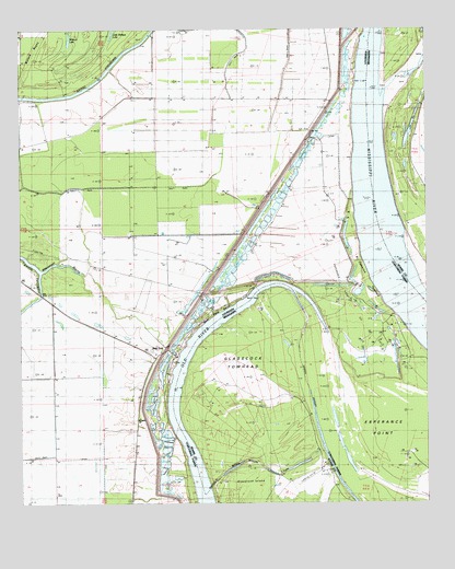
Deer Park, LA USGS Topographic Map
Click on map above to begin viewing in our Map Viewer.

This topographic map contains these locations and features:
Feature Name Type Latitude Longitude GNIS ID View Map
Ashley LandingLocaleN31.3763°W91.5712°548788View Map
Ashley PlantationLocaleN31.4357°W91.5362°548789View Map
Bougere ChurchChurchN31.3977°W91.5885°541984View Map
Briar LandingLocaleN31.3841°W91.5301°685915View Map
Briars ChuteStreamN31.3796°W91.5676°533385View Map
Briars ChuteLakeN31.3837°W91.5485°667553View Map
Briers (historical)LocaleN31.3835°W91.5335°685916View Map
Catherine Bend RevetmentLeveeN31.4252°W91.5085°549531View Map
Deer ParkPopulated PlaceN31.4174°W91.5815°554215View Map
Deer Park BendBendN31.4252°W91.5648°541987View Map
Deer Park Bend RevetmentLocaleN31.4218°W91.5698°548796View Map
Deer Park Oil FieldOilfieldN31.4307°W91.5826°534471View Map
Esperance PointCapeN31.3929°W91.5065°558216View Map
Esperance Point Oil FieldOilfieldN31.4249°W91.5260°534837View Map
Fish Pond LandingLocaleN31.4152°W91.5760°548800View Map
Fish Pond PlantationLocaleN31.4349°W91.5568°548801View Map
Ford Landing (historical)LocaleN31.4618°W91.5112°685951View Map
Gilham Sawmill Spur (historical)LocaleN31.4552°W91.5521°548804View Map
Glasscock TowheadIslandN31.4085°W91.5535°670424View Map
Glasscock Towhead Oil FieldOilfieldN31.4266°W91.5515°685966View Map
Mississippi BayouStreamN31.4366°W91.6185°537162View Map
Moro LandingLocaleN31.4932°W91.5207°548814View Map
Moro PlantationLocaleN31.4849°W91.5298°548815View Map
Morville LandingLocaleN31.4682°W91.5221°548816View Map
Morville PlantationLocaleN31.4682°W91.5293°548817View Map
Morville RevetmentLeveeN31.4941°W91.5204°548818View Map
North Esperance Oil FieldOilfieldN31.4585°W91.5093°686029View Map
Old RiverLakeN31.3821°W91.5707°541991View Map
Saint Catherine TowheadIslandN31.4327°W91.5196°538818View Map
Saint James ChurchChurchN31.3857°W91.5846°538862View Map
Southwest Deer Park Oil FieldOilfieldN31.3827°W91.6187°544679View Map
Stonefield ChurchChurchN31.4679°W91.5396°539682View Map
Surgent Ashley PlantationLocaleN31.3910°W91.5876°548834View Map
Union Church (historical)ChurchN31.4146°W91.5826°548836View Map
Wallace LakeLakeN31.4972°W91.6096°556352View Map
Warnicott (historical)Populated PlaceN31.4585°W91.5312°544697View Map
Warnicott LandingLocaleN31.4582°W91.5223°548838View Map
Warnicott Oil FieldOilfieldN31.4535°W91.5651°540236View Map

Note: Coordinates in the location and feature list above are referenced to NAD83 datum.


Copyright (C) 2008-2024 Ryan Niemi / Sunset Dynamics ... All Rights Reserved