TopoQuest Logo
Do you find TopoQuest useful?
Help keep TopoQuest running and adding new maps/features by donating!
Bitcoin:  19c7KJd3qBynnjoSw5npx9KScwjBe4ifkT
Litecoin:  LXs6TkuXGGXo1vDsWCkWVdjQX94eUKd6ui
Home View Maps Find Maps Find Places Resources & Links


Dead Lakes, Florida Topographic Map

USGS Map Title: Dead Lakes, FL
USGS Map MRC: 30085B2
DRG (GeoTIFF) Download: o30085b2.tif


Neighboring USGS Topographic Map Quads:


  Frink, FL  
30085C2
 

  Estiffanulga, FL  
30085C1


  Dead Lakes, FL  
30085B2
 

  Orange, FL  
30085B1
 

  Wetappo Creek, FL  
30085A3
 

  Wewahitchka, FL  
30085A2
 

  Kennedy Creek, FL  
30085A1


Map MRC Location:

N31°
W86°
N31°
W85°
H8 H7 H6 H5 H4 H3 H2 H1
G8 G7 G6 G5 G4 G3 G2 G1
F8 F7 F6 F5 F4 F3 F2 F1
E8 E7 E6 E5 E4 E3 E2 E1
D8 D7 D6 D5 D4 D3 D2 D1
C8 C7 C6 C5 C4 C3 C2 C1
B8 B7 B6 B5 B4 B3 B2 B1
A8 A7 A6 A5 A4 A3 A2 A1
N30°
W86°
N30°
W85°

Dead Lakes, FL USGS 1:24K Topographic Map Preview:
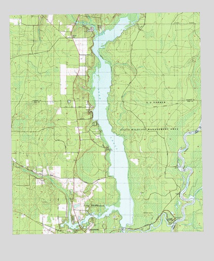
Dead Lakes, FL USGS Topographic Map
Click on map above to begin viewing in our Map Viewer.

This topographic map contains these locations and features:
Feature Name Type Latitude Longitude GNIS ID View Map
Big BranchStreamN30.1652°W85.2494°278644View Map
Brown CreekStreamN30.2210°W85.1771°304834View Map
Chipola CutoffGutN30.1288°W85.1574°294633View Map
Chipola ParkLocaleN30.2369°W85.2094°280403View Map
Clark BranchStreamN30.1813°W85.1788°304833View Map
Crooked CreekStreamN30.2477°W85.1971°281069View Map
Dead LakesLakeN30.2038°W85.1897°281381View Map
Dead Lakes State ParkParkN30.1394°W85.2005°304837View Map
Estanifanulga (historical)Populated PlaceN30.1669°W85.1332°294542View Map
First Baptist ChurchChurchN30.1710°W85.1569°301831View Map
Florida RiverStreamN30.1449°W85.1307°305681View Map
G U Parker Wildlife Management AreaParkN30.1849°W85.1574°300137View Map
Glenwood Church of ChristChurchN30.1599°W85.1596°301806View Map
Greenback LakeLakeN30.1297°W85.1336°304830View Map
Guardhouse BranchStreamN30.1280°W85.2102°283477View Map
IolaPopulated PlaceN30.1488°W85.1652°295377View Map
Iola LakeLakeN30.1617°W85.1394°304832View Map
Jehu CemeteryCemeteryN30.1305°W85.1974°284739View Map
Kentucky LakeLakeN30.1550°W85.1374°304831View Map
Kentucky LandingLocaleN30.1488°W85.1396°295389View Map
McCabe IslandIslandN30.1363°W85.1624°304836View Map
Parker Plaza Shopping CenterLocaleN30.1669°W85.2010°295892View Map
Silver LakeLakeN30.1274°W85.1300°304828View Map
State Fish Hatchery (historical)LocaleN30.1380°W85.1999°294640View Map
Stone Mill CreekStreamN30.1402°W85.1813°291723View Map
West Arm BridgeBridgeN30.1294°W85.2069°303572View Map
West Arm of Dead LakesLakeN30.1340°W85.1999°304835View Map
Woodcock LakeLakeN30.1410°W85.1413°293497View Map

Note: Coordinates in the location and feature list above are referenced to NAD83 datum.


Copyright (C) 2008-2024 Ryan Niemi / Sunset Dynamics ... All Rights Reserved