TopoQuest Logo
Do you find TopoQuest useful?
Help keep TopoQuest running and adding new maps/features by donating!
Bitcoin:  19c7KJd3qBynnjoSw5npx9KScwjBe4ifkT
Litecoin:  LXs6TkuXGGXo1vDsWCkWVdjQX94eUKd6ui
Home View Maps Find Maps Find Places Resources & Links


Dawson, Texas Topographic Map

USGS Map Title: Dawson, TX
USGS Map MRC: 31096H6
DRG (GeoTIFF) Download: o31096h6.tif


Neighboring USGS Topographic Map Quads:


  Frost, TX  
32096A7
 

  Blooming Grove, TX  
32096A6
 

  Corbet, TX  
32096A5
 

  Irene, TX  
31096H7
 

  Dawson, TX  
31096H6
 

  Purdon, TX  
31096H5
 

  Hubbard, TX  
31096G7
 

  Coolidge, TX  
31096G6
 

  Union High, TX  
31096G5


Map MRC Location:

N32°
W97°
N32°
W96°
H8 H7 H6 H5 H4 H3 H2 H1
G8 G7 G6 G5 G4 G3 G2 G1
F8 F7 F6 F5 F4 F3 F2 F1
E8 E7 E6 E5 E4 E3 E2 E1
D8 D7 D6 D5 D4 D3 D2 D1
C8 C7 C6 C5 C4 C3 C2 C1
B8 B7 B6 B5 B4 B3 B2 B1
A8 A7 A6 A5 A4 A3 A2 A1
N31°
W97°
N31°
W96°

Dawson, TX USGS 1:24K Topographic Map Preview:
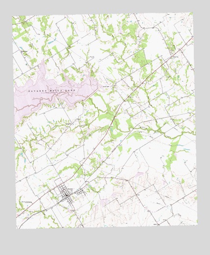
Dawson, TX USGS Topographic Map
Click on map above to begin viewing in our Map Viewer.

This topographic map contains these locations and features:
Feature Name Type Latitude Longitude GNIS ID View Map
Alliance Creek Nature TrailTrailN31.9677°W96.6978°2032984View Map
Alliance HallLocaleN31.9752°W96.6933°1329409View Map
Battle Creek Burial Ground Historical MarkerParkN31.8904°W96.7394°1330147View Map
Brushie Prairie ChurchChurchN31.9796°W96.7447°1331406View Map
DawsonPopulated PlaceN31.8940°W96.7147°1334106View Map
Dawson City HallBuildingN31.8946°W96.7152°2753945View Map
Dawson High SchoolSchoolN31.8968°W96.7144°2007365View Map
Dawson Post OfficePost OfficeN31.8946°W96.7152°2731734View Map
Dawson Volunteer Fire DepartmentBuildingN31.8935°W96.7152°2552289View Map
Knapp Pecan Orchard AirparkAirportN31.9745°W96.6795°1386509View Map
Lake Dawson DamDamN31.8752°W96.7069°1859434View Map
Larkin Hill CreekStreamN31.8829°W96.7053°1339637View Map
Liberty Hill ParkParkN31.9488°W96.6992°2028932View Map
Navarro MillsPopulated PlaceN31.9579°W96.6822°1378728View Map
Navarro Mills DamDamN31.9502°W96.7003°1854265View Map
Navarro Mills LakeReservoirN31.9493°W96.7475°1342381View Map
Navarro Mills Volunteer Fire DepartmentBuildingN31.9602°W96.6851°2552529View Map
Oak ParkParkN31.9635°W96.6919°2029614View Map
Post Oak CreekStreamN31.9299°W96.6480°1344407View Map
Shiloh ChurchChurchN31.8760°W96.6522°1347053View Map
Silver CityPopulated PlaceN31.9746°W96.6405°1379077View Map
Soil Conservation Service Site 105 DamDamN31.9352°W96.6986°1859458View Map
Soil Conservation Service Site 105 ReservoirReservoirN31.9352°W96.6986°1859459View Map
Soil Conservation Service Site 108 DamDamN31.8852°W96.7119°1859440View Map
Soil Conservation Service Site 108 ReservoirReservoirN31.8853°W96.7137°1859441View Map
Soil Conservation Service Site 109 DamDamN31.8868°W96.6936°1859456View Map
Soil Conservation Service Site 109 ReservoirReservoirN31.8865°W96.6949°1859457View Map
Soil Conservation Service Site 110 DamDamN31.8935°W96.6869°1859442View Map
Soil Conservation Service Site 110 ReservoirReservoirN31.8935°W96.6869°1859443View Map
Soil Conservation Service Site 111 DamDamN31.8952°W96.6836°1859450View Map
Soil Conservation Service Site 111 ReservoirReservoirN31.8937°W96.6828°1859451View Map
Soil Conservation Service Site 112 DamDamN31.9135°W96.6903°1859448View Map
Soil Conservation Service Site 112 ReservoirReservoirN31.9145°W96.6923°1859449View Map
Soil Conservation Service Site 113 DamDamN31.9068°W96.6653°1859446View Map
Soil Conservation Service Site 113 ReservoirReservoirN31.9055°W96.6653°1859447View Map
Soil Conservation Service Site 114 DamDamN31.9018°W96.6469°1859444View Map
Soil Conservation Service Site 114 ReservoirReservoirN31.9001°W96.6478°1859445View Map
Soil Conservation Service Site 126 DamDamN31.9885°W96.6753°1859454View Map
Soil Conservation Service Site 126 ReservoirReservoirN31.9913°W96.6751°1859455View Map
Soil Conservation Service Site 127 DamDamN31.9818°W96.6653°1859452View Map
Soil Conservation Service Site 127 ReservoirReservoirN31.9840°W96.6642°1859453View Map
Spring HillPopulated PlaceN31.9363°W96.7103°1379100View Map
Spring Hill CemeteryCemeteryN31.9293°W96.6992°1347737View Map
Tom Harris BranchStreamN31.9579°W96.7478°1376475View Map
Town of DawsonCivilN31.8941°W96.7151°2412409View Map
Treadwell BranchStreamN31.9438°W96.6917°1376495View Map
Wolf CreekStreamN31.9615°W96.7308°1350465View Map
Wolf Creek ParkParkN31.9779°W96.7311°2029894View Map
Younger CemeteryCemeteryN31.9624°W96.6447°1350700View Map

Note: Coordinates in the location and feature list above are referenced to NAD83 datum.


Copyright (C) 2008-2024 Ryan Niemi / Sunset Dynamics ... All Rights Reserved