TopoQuest Logo
Do you find TopoQuest useful?
Help keep TopoQuest running and adding new maps/features by donating!
Bitcoin:  19c7KJd3qBynnjoSw5npx9KScwjBe4ifkT
Litecoin:  LXs6TkuXGGXo1vDsWCkWVdjQX94eUKd6ui
Home View Maps Find Maps Find Places Resources & Links


Darlington West, South Carolina Topographic Map

USGS Map Title: Darlington West, SC
USGS Map MRC: 34079C8
DRG (GeoTIFF) Download: o34079c8.tif


Neighboring USGS Topographic Map Quads:


  Hartsville North, SC  
34080D1
 

  Dovesville, SC  
34079D8
 

  Mont Clare, SC  
34079D7
 

  Hartsville South, SC  
34080C1
 

  Darlington West, SC  
34079C8
 

  Darlington East, SC  
34079C7
 

  Lamar, SC  
34080B1
 

  Timmonsville, SC  
34079B8
 

  Florence West, SC  
34079B7


Map MRC Location:

N35°
W80°
N35°
W79°
H8 H7 H6 H5 H4 H3 H2 H1
G8 G7 G6 G5 G4 G3 G2 G1
F8 F7 F6 F5 F4 F3 F2 F1
E8 E7 E6 E5 E4 E3 E2 E1
D8 D7 D6 D5 D4 D3 D2 D1
C8 C7 C6 C5 C4 C3 C2 C1
B8 B7 B6 B5 B4 B3 B2 B1
A8 A7 A6 A5 A4 A3 A2 A1
N34°
W80°
N34°
W79°

Darlington West, SC USGS 1:24K Topographic Map Preview:
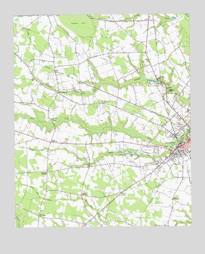
Darlington West, SC USGS Topographic Map
Click on map above to begin viewing in our Map Viewer.

This topographic map contains these locations and features:
Feature Name Type Latitude Longitude GNIS ID View Map
Auburn School (historical)SchoolN34.3727°W79.9701°1240799View Map
Bell AcresPopulated PlaceN34.3215°W79.8856°1240802View Map
Bethel African Methodist Episcopal ChurhChurchN34.2946°W79.8773°1240803View Map
Branhams AirportAirportN34.2861°W79.9295°1251886View Map
Brockington HeightsPopulated PlaceN34.2913°W79.8834°1240811View Map
Brockington SchoolSchoolN34.2865°W79.8859°1246998View Map
Brunson Dargan Junior High SchoolSchoolN34.3077°W79.8801°1240813View Map
Bryant CemeteryCemeteryN34.3379°W79.9431°1221055View Map
Byrd CemeteryCemeteryN34.3313°W79.9573°1221183View Map
Cannon CemeteryCemeteryN34.2896°W79.8826°1221325View Map
Cherry Grove CemeteryCemeteryN34.3299°W79.9545°1221539View Map
Cherry Grove ChurchChurchN34.3229°W79.9367°1247270View Map
Cherry Grove School (historical)SchoolN34.3232°W79.9381°1240824View Map
Church of GodChurchN34.2954°W79.8790°1240826View Map
Country OakPopulated PlaceN34.3163°W79.8984°1240867View Map
Cypress FlatFlatN34.3696°W79.9523°1247474View Map
DarlingtonPopulated PlaceN34.2999°W79.8762°1247486View Map
Darlington Career CenterSchoolN34.3188°W79.8812°1240840View Map
Darlington City Fire DepartmentBuildingN34.3010°W79.8765°2578346View Map
Darlington City HallBuildingN34.3007°W79.8762°1240841View Map
Darlington CountyCivilN34.3324°W79.9577°1247992View Map
Darlington County Emergency Medical ServicesBuildingN34.2984°W79.9248°2578584View Map
Darlington County Fire Department HeadquartersBuildingN34.3024°W79.9729°2578634View Map
Darlington County Fire Department Station 3BuildingN34.3193°W79.9066°2578179View Map
Darlington County Fire Department Swift CreekBuildingN34.3023°W79.9729°2578328View Map
Darlington Plaza Shopping CenterLocaleN34.2918°W79.8906°1240847View Map
Darlington Police DepartmentBuildingN34.3007°W79.8764°2734253View Map
Darlington Post OfficePost OfficeN34.3193°W79.8825°1252239View Map
Darlington RacewayLocaleN34.2952°W79.9053°1247487View Map
Dubose CrossroadsPopulated PlaceN34.2568°W79.9823°1247566View Map
Earlwood ParkPopulated PlaceN34.3290°W79.8915°1231251View Map
Earlys CrossroadsPopulated PlaceN34.3004°W79.9740°1247593View Map
Epworth United Methodist ChurchChurchN34.2979°W79.8809°1240856View Map
First Church of GodChurchN34.3007°W79.8781°1240861View Map
First Pentecostal Holiness ChurchChurchN34.2935°W79.8828°1240862View Map
Flowers CemeteryCemeteryN34.3365°W79.9859°1222464View Map
FloydPopulated PlaceN34.3710°W79.9037°1247785View Map
Graham AirportAirportN34.3495°W79.8811°2650808View Map
Hunters RidgePopulated PlaceN34.3093°W79.8923°1240995View Map
Indian Branch CemeteryCemeteryN34.2896°W79.9489°1223429View Map
Indian Branch ChurchChurchN34.2860°W79.9470°1223430View Map
Indian Branch School (historical)SchoolN34.2857°W79.9465°1240893View Map
Indian Branch School (historical)SchoolN34.2863°W79.9337°1240894View Map
Indian CreekStreamN34.2979°W79.8878°1246114View Map
Iseman CrossroadsPopulated PlaceN34.2688°W79.9528°1246132View Map
Law CemeteryCemeteryN34.3468°W79.9070°1223839View Map
Lewis CrossroadsPopulated PlaceN34.3290°W79.9687°1231477View Map
Lucas CreekStreamN34.3746°W79.8765°1224226View Map
LunnPopulated PlaceN34.3415°W79.9703°1227942View Map
Magnolia CemeteryCemeteryN34.2960°W79.8903°1224268View Map
McCowans Mill (historical)LocaleN34.3354°W79.8976°1240918View Map
McCowns MillpondReservoirN34.3357°W79.9018°1224394View Map
McCowns Millpond Dam D-3535DamN34.3349°W79.8978°1240063View Map
Medsouth TransportationBuildingN34.2761°W79.8814°2739629View Map
Mill CemeteryCemeteryN34.3032°W79.8859°1224527View Map
Mineral SpringSpringN34.3274°W79.8834°1240924View Map
Mineral Springs ParkParkN34.3271°W79.8834°1231550View Map
Oak Grove ChurchChurchN34.3602°W79.9134°1240944View Map
Oak Grove School (historical)SchoolN34.3599°W79.9137°1240945View Map
Odom CemeteryCemeteryN34.2899°W79.9545°1225163View Map
Parrotts Mill (historical)LocaleN34.3113°W79.9720°1240950View Map
Pate SchoolSchoolN34.2877°W79.8976°1250032View Map
Quail HollowPopulated PlaceN34.3229°W79.9026°1240962View Map
Quarters CemeteryCemeteryN34.2879°W79.9162°1225715View Map
Ramsey PondReservoirN34.2935°W79.9157°1238466View Map
Red Hill CemeteryCemeteryN34.3376°W79.8962°1225785View Map
Rogers CrossroadsPopulated PlaceN34.2660°W79.8878°1227975View Map
Royal OaksPopulated PlaceN34.3140°W79.8834°1240970View Map
Saint John Historic DistrictParkN34.3043°W79.8753°1240974View Map
Saint Johns High SchoolSchoolN34.3196°W79.8801°1240976View Map
Saint Johns SchoolSchoolN34.3052°W79.8756°1250562View Map
Saint Josephs ChurchChurchN34.3310°W79.8909°1250566View Map
Second Baptist ChurchChurchN34.2965°W79.8820°1240989View Map
South Carolina Highway Patrol Troop 5 Post ABuildingN34.3039°W79.9868°2734329View Map
South Carolina Noname 16022 D-3537 DamDamN34.2927°W79.9103°1238465View Map
Spring AcresPopulated PlaceN34.3293°W79.8817°1240998View Map
Spring SchoolSchoolN34.3177°W79.8765°1251005View Map
Swan Lake (historical)LakeN34.3452°W79.9484°1241002View Map
Swift Creek CemeteryCemeteryN34.3143°W79.9751°1241003View Map
Swift Creek ChurchChurchN34.3135°W79.9731°1227000View Map
Swift Creek School (historical)SchoolN34.3132°W79.9742°1241004View Map
Temple ChurchChurchN34.3474°W79.9042°1251135View Map
Union Baptist ChurchChurchN34.2913°W79.8837°1241013View Map
WDAR-AM (Darlington)TowerN34.3163°W79.8878°1252337View Map
WDAR-FM (Darlington)TowerN34.3163°W79.8878°1252479View Map
Wesley Memorial Methodist ChurchChurchN34.3143°W79.8878°1241019View Map
Williams EstatesPopulated PlaceN34.3307°W79.8926°1241024View Map
Wineberg CrossroadsPopulated PlaceN34.2827°W79.9767°1251472View Map

Note: Coordinates in the location and feature list above are referenced to NAD83 datum.


Copyright (C) 2008-2024 Ryan Niemi / Sunset Dynamics ... All Rights Reserved