TopoQuest Logo
Do you find TopoQuest useful?
Help keep TopoQuest running and adding new maps/features by donating!
Bitcoin:  19c7KJd3qBynnjoSw5npx9KScwjBe4ifkT
Litecoin:  LXs6TkuXGGXo1vDsWCkWVdjQX94eUKd6ui
Home View Maps Find Maps Find Places Resources & Links


Dane Canyon, Arizona Topographic Map

USGS Map Title: Dane Canyon, AZ
USGS Map MRC: 34111D2
DRG (GeoTIFF) Download: o34111d2.tif


Neighboring USGS Topographic Map Quads:


  Long Valley, AZ  
34111E3
 

  Blue Ridge Reservoir, AZ  
34111E2
 

  Leonard Canyon, AZ  
34111E1
 

  Kehl Ridge, AZ  
34111D3
 

  Dane Canyon, AZ  
34111D2
 

  Knoll Lake, AZ  
34111D1
 

  Payson North, AZ  
34111C3
 

  Diamond Point, AZ  
34111C2
 

  Promontory Butte, AZ  
34111C1


Map MRC Location:

N35°
W112°
N35°
W111°
H8 H7 H6 H5 H4 H3 H2 H1
G8 G7 G6 G5 G4 G3 G2 G1
F8 F7 F6 F5 F4 F3 F2 F1
E8 E7 E6 E5 E4 E3 E2 E1
D8 D7 D6 D5 D4 D3 D2 D1
C8 C7 C6 C5 C4 C3 C2 C1
B8 B7 B6 B5 B4 B3 B2 B1
A8 A7 A6 A5 A4 A3 A2 A1
N34°
W112°
N34°
W111°

Dane Canyon, AZ USGS 1:24K Topographic Map Preview:
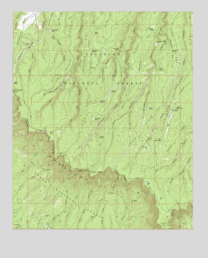
Dane Canyon, AZ USGS Topographic Map
Click on map above to begin viewing in our Map Viewer.

This topographic map contains these locations and features:
Feature Name Type Latitude Longitude GNIS ID View Map
Aspen SpringSpringN34.4883°W111.1941°25825View Map
Backhoe Tank Number SixReservoirN34.4764°W111.1319°2056527View Map
Barbershop SpringSpringN34.4383°W111.1944°25971View Map
Bill McClintock DrawValleyN34.4598°W111.1571°26327View Map
Bonita Creek EstatesPopulated PlaceN34.3786°W111.2243°2056532View Map
Box CanyonValleyN34.4809°W111.2362°26678View Map
Buck Springs CabinLocaleN34.4434°W111.1407°26879View Map
Buck Springs RidgeRidgeN34.4759°W111.1287°26880View Map
Burnt PointCliffN34.4086°W111.2035°27032View Map
Coyote SpringSpringN34.4446°W111.1564°28130View Map
Crackerbox SpringSpringN34.4972°W111.2479°37731View Map
Dane RidgeRidgeN34.4925°W111.1426°28266View Map
Dane SpringSpringN34.4668°W111.1494°28267View Map
Dick Hart RidgeRidgeN34.4625°W111.1951°28466View Map
Drift Fence SpringSpringN34.4782°W111.1774°28594View Map
Dude LakeLakeN34.4304°W111.2255°28659View Map
East Bear CanyonValleyN34.4628°W111.2090°28732View Map
Floyd SpringSpringN34.4764°W111.1551°2056526View Map
Fred Haught CanyonValleyN34.4897°W111.2274°29174View Map
Fred Haught RidgeRidgeN34.4809°W111.2115°29175View Map
Fred Haught SpringSpringN34.4889°W111.2242°29176View Map
Holder CabinLocaleN34.4217°W111.1571°30051View Map
Hospital RidgeRidgeN34.4361°W111.1276°30220View Map
Lost LakeLakeN34.3929°W111.1496°31304View Map
Lower Buck SpringSpringN34.4446°W111.1373°31337View Map
Maverick CanyonValleyN34.4745°W111.1812°31578View Map
McClintock RidgeRidgeN34.4653°W111.1687°31631View Map
McClintock SpringSpringN34.4897°W111.1532°31632View Map
McFarland SpringSpringN34.4772°W111.1960°31665View Map
Merritt DrawValleyN34.4942°W111.1660°31717View Map
Merritt SpringSpringN34.4543°W111.1823°31718View Map
Middle Leonard Number Four SpringSpringN34.4053°W111.1410°2056530View Map
Middle Leonard Number Two SpringSpringN34.3989°W111.1462°2056531View Map
Moonshine DrawValleyN34.4878°W111.1460°31994View Map
Moonshine SpringSpringN34.4775°W111.1405°31999View Map
Myrtle LakeLakeN34.4017°W111.1585°32223View Map
Myrtle TrailTrailN34.4011°W111.1801°32226View Map
Nonsuitable TankReservoirN34.4292°W111.1846°2056528View Map
Pinchot SpringSpringN34.4925°W111.1951°44736View Map
Schneider SpringSpringN34.4848°W111.1312°2056525View Map
Turkey SpringSpringN34.4279°W111.1903°35575View Map
Upper Buck SpringSpringN34.4261°W111.1477°35673View Map
West Bear CanyonValleyN34.4581°W111.2165°35960View Map
West Moonshine DrawValleyN34.4848°W111.1437°36007View Map
West Moonshine SpringSpringN34.4828°W111.1445°36008View Map
Whistling SpringSpringN34.4484°W111.1906°36060View Map
Yeager TankReservoirN34.4311°W111.1576°2056529View Map

Note: Coordinates in the location and feature list above are referenced to NAD83 datum.


Copyright (C) 2008-2024 Ryan Niemi / Sunset Dynamics ... All Rights Reserved