TopoQuest Logo
Do you find TopoQuest useful?
Help keep TopoQuest running and adding new maps/features by donating!
Bitcoin:  19c7KJd3qBynnjoSw5npx9KScwjBe4ifkT
Litecoin:  LXs6TkuXGGXo1vDsWCkWVdjQX94eUKd6ui
Home View Maps Find Maps Find Places Resources & Links


Dam Lake, Wisconsin Topographic Map

USGS Map Title: Dam Lake, WI
USGS Map MRC: 45089G4
DRG (GeoTIFF) Download: o45089g4.tif


Neighboring USGS Topographic Map Quads:


  Sayner, WI  
45089H5
 

  Saint Germain, WI  
45089H4
 

  Eagle River West, WI  
45089H3
 

  Lake Tomahawk, WI  
45089G5
 

  Dam Lake, WI  
45089G4
 

  Sugar Camp, WI  
45089G3
 

  McNaughton, WI  
45089F5
 

  Rhinelander, WI  
45089F4
 

  Moen Lake, WI  
45089F3


Map MRC Location:

N46°
W90°
N46°
W89°
H8 H7 H6 H5 H4 H3 H2 H1
G8 G7 G6 G5 G4 G3 G2 G1
F8 F7 F6 F5 F4 F3 F2 F1
E8 E7 E6 E5 E4 E3 E2 E1
D8 D7 D6 D5 D4 D3 D2 D1
C8 C7 C6 C5 C4 C3 C2 C1
B8 B7 B6 B5 B4 B3 B2 B1
A8 A7 A6 A5 A4 A3 A2 A1
N45°
W90°
N45°
W89°

Dam Lake, WI USGS 1:24K Topographic Map Preview:
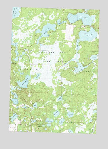
Dam Lake, WI USGS Topographic Map
Click on map above to begin viewing in our Map Viewer.

This topographic map contains these locations and features:
Feature Name Type Latitude Longitude GNIS ID View Map
American Legion State ForestForestN45.8266°W89.4399°1560825View Map
Brown LakeLakeN45.7803°W89.4922°1562264View Map
Clear LakeLakeN45.8061°W89.4614°1563157View Map
Cranberry LakeLakeN45.7739°W89.4682°1563486View Map
Dam LakeReservoirN45.8675°W89.3995°1563683View Map
Dam, Sand, Stone, Echo, Chain LakesReservoirN45.8675°W89.3995°1793008View Map
Echo LakeLakeN45.8269°W89.3811°1564426View Map
Indian CreekStreamN45.8241°W89.4071°1566908View Map
Jenny Barnes LakeLakeN45.7693°W89.4325°1567152View Map
Kate Pier CreekStreamN45.7502°W89.4824°1567355View Map
Kate Pier LakeLakeN45.7609°W89.4655°1567356View Map
Little Spider LakeLakeN45.7610°W89.4323°1568421View Map
Long LakeLakeN45.7879°W89.4952°1568564View Map
Lost LakeLakeN45.7514°W89.4114°1568684View Map
Lynn LakeLakeN45.7630°W89.3826°1568848View Map
Muskellunge CreekStreamN45.8269°W89.4771°1570061View Map
Muskellunge LakeLakeN45.7999°W89.4795°1570066View Map
North Nokomis LakeLakeN45.8520°W89.4515°1570472View Map
Oatmeal LakeLakeN45.7687°W89.4125°1570732View Map
Paradise LakeLakeN45.8605°W89.4289°1571022View Map
Pickerel LakeLakeN45.7845°W89.4281°1571327View Map
Sand LakeLakeN45.8490°W89.3909°1573679View Map
Shallow LakeLakeN45.7745°W89.4781°1573951View Map
Spider LakeLakeN45.7607°W89.4425°1574543View Map
Stone LakeLakeN45.7742°W89.4889°1574923View Map
Stone LakeLakeN45.8157°W89.4020°1574924View Map
Stone Lake Pines State Natural AreaParkN45.7764°W89.3944°2095670View Map
Sugar Camp 1909C361 DamDamN45.8716°W89.3951°1793007View Map
Tim Lynn LakeLakeN45.7612°W89.4248°1575457View Map
Tom Doyle LakeLakeN45.7641°W89.4933°1575489View Map
Town of NewboldCivilN45.7802°W89.4919°1583800View Map
Turtle LakeLakeN45.7768°W89.4631°1575741View Map
Twin LakesLakeN45.7610°W89.4778°1575806View Map
West Spider LakeLakeN45.7566°W89.4508°1576563View Map

Note: Coordinates in the location and feature list above are referenced to NAD83 datum.


Copyright (C) 2008-2024 Ryan Niemi / Sunset Dynamics ... All Rights Reserved