TopoQuest Logo
Do you find TopoQuest useful?
Help keep TopoQuest running and adding new maps/features by donating!
Bitcoin:  19c7KJd3qBynnjoSw5npx9KScwjBe4ifkT
Litecoin:  LXs6TkuXGGXo1vDsWCkWVdjQX94eUKd6ui
Home View Maps Find Maps Find Places Resources & Links


Crystal Mountain, Colorado Topographic Map

USGS Map Title: Crystal Mountain, CO
USGS Map MRC: 40105E4
DRG (GeoTIFF) Download: o40105e4.tif


Neighboring USGS Topographic Map Quads:


  Rustic, CO  
40105F5
 

  Big Narrows, CO  
40105F4
 

  Poudre Park, CO  
40105F3
 

  Pingree Park, CO  
40105E5
 

  Crystal Mountain, CO  
40105E4
 

  Buckhorn Mountain, CO  
40105E3
 

  Estes Park, CO  
40105D5
 

  Glen Haven, CO  
40105D4
 

  Drake, CO  
40105D3


Map MRC Location:

N41°
W106°
N41°
W105°
H8 H7 H6 H5 H4 H3 H2 H1
G8 G7 G6 G5 G4 G3 G2 G1
F8 F7 F6 F5 F4 F3 F2 F1
E8 E7 E6 E5 E4 E3 E2 E1
D8 D7 D6 D5 D4 D3 D2 D1
C8 C7 C6 C5 C4 C3 C2 C1
B8 B7 B6 B5 B4 B3 B2 B1
A8 A7 A6 A5 A4 A3 A2 A1
N40°
W106°
N40°
W105°

Crystal Mountain, CO USGS 1:24K Topographic Map Preview:
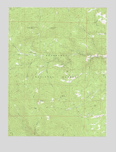
Crystal Mountain, CO USGS Topographic Map
Click on map above to begin viewing in our Map Viewer.

This topographic map contains these locations and features:
Feature Name Type Latitude Longitude GNIS ID View Map
Beryl Number Five ProspectMineN40.5450°W105.4128°1683535View Map
Big Boulder MineMineN40.5291°W105.4297°1683501View Map
Boiler HillSummitN40.5294°W105.3914°177331View Map
Box PrairiePopulated PlaceN40.5814°W105.4689°177327View Map
Box Prairie CreekStreamN40.5772°W105.4586°177337View Map
Buckhorn Ranger StationLocaleN40.5803°W105.4680°177326View Map
Calypso Beryl Number One MineMineN40.5433°W105.4511°1683503View Map
Cascade CreekStreamN40.5714°W105.4494°177340View Map
Clipper Number One MineMineN40.5350°W105.4594°1683504View Map
Corral Pole Mica MineMineN40.5569°W105.4130°1683505View Map
Corral Pole One MineMineN40.5569°W105.4117°1683498View Map
Corral Pole Two MineMineN40.5569°W105.4117°1683499View Map
Crystal MountainSummitN40.5391°W105.4325°177333View Map
Crystal Mountain MineMineN40.5414°W105.4300°1683506View Map
Crystal Silica MineMineN40.5416°W105.4311°1683507View Map
Crystal Snow MineMineN40.5269°W105.4030°1683500View Map
Debbie Doll Beryl ClaimMineN40.5561°W105.4489°1683508View Map
Donner Hill TrailTrailN40.5083°W105.4581°202453View Map
Donner PassGapN40.5272°W105.4631°177335View Map
Double Opening MineMineN40.5458°W105.3950°1683509View Map
East White Pine MountainSummitN40.6047°W105.4458°177329View Map
Elk CreekStreamN40.5700°W105.4725°177325View Map
Eureka Claim Number EightMineN40.5733°W105.4303°1683517View Map
Eureka Claim Number FiveMineN40.5733°W105.4303°1683514View Map
Eureka Claim Number FourMineN40.5733°W105.4303°1683513View Map
Eureka Claim Number OneMineN40.5733°W105.4303°1683510View Map
Eureka Claim Number SevenMineN40.5733°W105.4303°1683516View Map
Eureka Claim Number SixMineN40.5733°W105.4303°1683515View Map
Eureka Claim Number ThreeMineN40.5733°W105.4303°1683512View Map
Eureka Claim Number TwoMineN40.5733°W105.4303°1683511View Map
Green Quartz Beryl Claim Number EightMineN40.5205°W105.4072°1683525View Map
Green Quartz Beryl Claim Number FiveMineN40.5205°W105.4072°1683522View Map
Green Quartz Beryl Claim Number FourMineN40.5205°W105.4072°1683521View Map
Green Quartz Beryl Claim Number NineMineN40.5205°W105.4072°1683526View Map
Green Quartz Beryl Claim Number OneMineN40.5205°W105.4072°1683518View Map
Green Quartz Beryl Claim Number SevenMineN40.5205°W105.4072°1683524View Map
Green Quartz Beryl Claim Number SixMineN40.5205°W105.4072°1683523View Map
Green Quartz Beryl Claim Number ThreeMineN40.5205°W105.4072°1683520View Map
Green Quartz Beryl Claim Number TwoMineN40.5205°W105.4072°1683519View Map
High ParkFlatN40.5991°W105.3783°202456View Map
Huckleberry Beryl DepositMineN40.5503°W105.4911°1683527View Map
Humphrey Beryl PegmatiteMineN40.5375°W105.4083°1683528View Map
Kings Kanyon ClaimsMineN40.5578°W105.4700°1683529View Map
Lakey CanyonValleyN40.5749°W105.3956°177339View Map
Lookout MountainSummitN40.5344°W105.4597°177334View Map
Mona Number Four MineMineN40.5586°W105.4697°1735395View Map
Monument GulchValleyN40.5794°W105.4837°177336View Map
Pan ClaimsMineN40.5714°W105.4300°1683530View Map
Plains View MineMineN40.5211°W105.4089°1683531View Map
Prairie Divide MineMineN40.5194°W105.4517°1763881View Map
Primrose Beryl ClaimMineN40.5586°W105.4500°1683532View Map
Reta Beryl ClaimMineN40.5436°W105.4497°1683533View Map
Sheep Creek TrailTrailN40.5528°W105.3894°177328View Map
Thodab ClaimMineN40.5400°W105.4117°1683534View Map
Tourmaline ProspectMineN40.5722°W105.4261°1683536View Map
Turner HillSummitN40.5622°W105.4244°177332View Map
Twin Cabin GulchValleyN40.5778°W105.3872°177338View Map
West White Pine MountainSummitN40.6053°W105.4717°177330View Map
White Pine PassGapN40.6036°W105.4594°2094699View Map
White RockSummitN40.6232°W105.4993°202450View Map
Wisdom Ranch MineMineN40.6000°W105.3753°1683537View Map

Note: Coordinates in the location and feature list above are referenced to NAD83 datum.


Copyright (C) 2008-2024 Ryan Niemi / Sunset Dynamics ... All Rights Reserved