TopoQuest Logo
Do you find TopoQuest useful?
Help keep TopoQuest running and adding new maps/features by donating!
Bitcoin:  19c7KJd3qBynnjoSw5npx9KScwjBe4ifkT
Litecoin:  LXs6TkuXGGXo1vDsWCkWVdjQX94eUKd6ui
Home View Maps Find Maps Find Places Resources & Links


Crooked Creek, California Topographic Map

USGS Map Title: Crooked Creek, CA
USGS Map MRC: 37118D1
DRG (GeoTIFF) Download: o37118d1.tif


Neighboring USGS Topographic Map Quads:


  Mount Barcroft, CA  
37118E2
 

  Station Peak, CA  
37118E1
 

  Indian Garden Creek, CA  
37117E8
 

  Blanco Mountain, CA  
37118D2
 

  Crooked Creek, CA  
37118D1
 

  Chocolate Mountain, CA  
37117D8
 

  Westgard Pass, CA  
37118C2
 

  Deep Springs Lake, CA  
37118C1
 

  Soldier Pass, CA  
37117C8


Map MRC Location:

N38°
W119°
N38°
W118°
H8 H7 H6 H5 H4 H3 H2 H1
G8 G7 G6 G5 G4 G3 G2 G1
F8 F7 F6 F5 F4 F3 F2 F1
E8 E7 E6 E5 E4 E3 E2 E1
D8 D7 D6 D5 D4 D3 D2 D1
C8 C7 C6 C5 C4 C3 C2 C1
B8 B7 B6 B5 B4 B3 B2 B1
A8 A7 A6 A5 A4 A3 A2 A1
N37°
W119°
N37°
W118°

Crooked Creek, CA USGS 1:24K Topographic Map Preview:
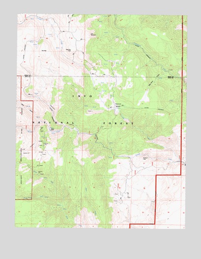
Crooked Creek, CA USGS Topographic Map
Click on map above to begin viewing in our Map Viewer.

This topographic map contains these locations and features:
Feature Name Type Latitude Longitude GNIS ID View Map
Arrastre MeadowFlatN37.4605°W118.0132°276413View Map
Black Birch CanyonValleyN37.4674°W118.0154°257099View Map
Crooked CreekStreamN37.4147°W118.0043°221844View Map
Dead Horse MeadowFlatN37.4458°W118.0504°266627View Map
Index HillSummitN37.4327°W118.1084°1667226View Map
Iron MountainSummitN37.4880°W118.0718°261815View Map
Log CanyonValleyN37.4305°W118.1132°1667234View Map
Mill CanyonValleyN37.4347°W118.0895°228662View Map
North Fork Birch CreekStreamN37.3883°W118.0915°229645View Map
Red PeakSummitN37.4777°W118.1076°265310View Map
Roberts RanchLocaleN37.4313°W118.1009°265458View Map
Roberts RidgeRidgeN37.4185°W118.1095°265459View Map
Royal GorgeGapN37.4277°W118.0673°1667247View Map
Sage Hen PeakSummitN37.4769°W118.0793°265722View Map
Sentinal PeakSummitN37.4158°W118.0326°1667253View Map
South Fork Birch CreekStreamN37.3888°W118.0912°234973View Map
Southbend MineMineN37.4058°W118.1079°267541View Map
Water CanyonValleyN37.4374°W118.1076°268802View Map
Wilkerson MineMineN37.4247°W118.1054°269106View Map

Note: Coordinates in the location and feature list above are referenced to NAD83 datum.


Copyright (C) 2008-2024 Ryan Niemi / Sunset Dynamics ... All Rights Reserved