TopoQuest Logo
Do you find TopoQuest useful?
Help keep TopoQuest running and adding new maps/features by donating!
Bitcoin:  19c7KJd3qBynnjoSw5npx9KScwjBe4ifkT
Litecoin:  LXs6TkuXGGXo1vDsWCkWVdjQX94eUKd6ui
Home View Maps Find Maps Find Places Resources & Links


Crane Lake, Minnesota Topographic Map

USGS Map Title: Crane Lake, MN
USGS Map MRC: 48092C4
DRG (GeoTIFF) Download: o48092c4.tif


Neighboring USGS Topographic Map Quads:


  O'Leary Lake, MN  
48092D5
 

  Redhorse Bay, MN  
48092D4


  Johnson Lake, MN  
48092C5
 

  Crane Lake, MN  
48092C4
 

  Snow Bay, MN  
48092C3
 

  Kabustasa Lake, MN  
48092B5
 

  Echo Lake, MN  
48092B4
 

  Lake Jeanette, MN  
48092B3


Map MRC Location:

N49°
W93°
N49°
W92°
H8 H7 H6 H5 H4 H3 H2 H1
G8 G7 G6 G5 G4 G3 G2 G1
F8 F7 F6 F5 F4 F3 F2 F1
E8 E7 E6 E5 E4 E3 E2 E1
D8 D7 D6 D5 D4 D3 D2 D1
C8 C7 C6 C5 C4 C3 C2 C1
B8 B7 B6 B5 B4 B3 B2 B1
A8 A7 A6 A5 A4 A3 A2 A1
N48°
W93°
N48°
W92°

Crane Lake, MN USGS 1:24K Topographic Map Preview:
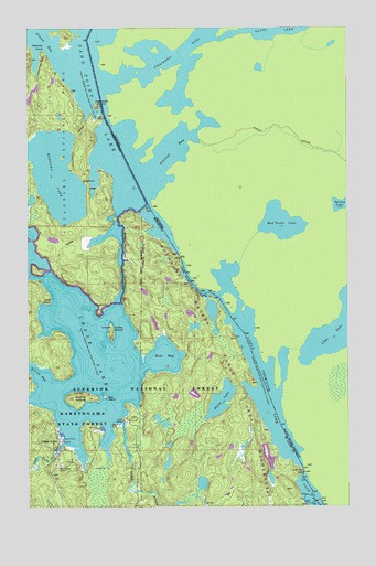
Crane Lake, MN USGS Topographic Map
Click on map above to begin viewing in our Map Viewer.

This topographic map contains these locations and features:
Feature Name Type Latitude Longitude GNIS ID View Map
Baylis IslandIslandN48.2782°W92.4793°660726View Map
Bear IslandIslandN48.2785°W92.4702°660738View Map
Camp Forty CreekStreamN48.2666°W92.4868°660937View Map
Crane LakeLakeN48.2900°W92.4763°661064View Map
Crane LakePopulated PlaceN48.2666°W92.4885°661065View Map
Crane Lake ChapelChurchN48.2607°W92.4879°661066View Map
Crane Lake Post OfficePost OfficeN48.2655°W92.4890°662884View Map
Crane Lake Volunteer Fire DepartmentBuildingN48.2600°W92.4880°2666505View Map
Dovre LakeLakeN48.2778°W92.4249°661133View Map
East BayBayN48.2893°W92.4468°661166View Map
Echo RiverStreamN48.2721°W92.4638°661183View Map
Harding Post Office (historical)Post OfficeN48.2694°W92.4889°2123638View Map
Harrison NarrowsGapN48.3521°W92.4704°661426View Map
Indian IslandIslandN48.2955°W92.4679°661541View Map
Ingersolls IslandIslandN48.3546°W92.4735°661550View Map
King Williams NarrowsChannelN48.3155°W92.4632°661641View Map
Little Vermilion LakeLakeN48.2881°W92.4111°661727View Map
Little Vermilion NarrowsChannelN48.3082°W92.4360°661781View Map
Loon RiverStreamN48.2591°W92.3929°661812View Map
Monroe PointCapeN48.3694°W92.4940°660493View Map
Mukooda LakeLakeN48.3365°W92.4885°662006View Map
Rollick BayBayN48.2866°W92.4999°662291View Map
Sand Beach CampgroundLocaleN48.2630°W92.4018°660498View Map
Scotts Seaplane BaseAirportN48.2663°W92.4835°660595View Map
United States Customs and Border Protection - Port of Entry - Crane LakeBuildingN48.2667°W92.4879°2758634View Map
Wolf PointCapeN48.3038°W92.4927°662826View Map

Note: Coordinates in the location and feature list above are referenced to NAD83 datum.


Copyright (C) 2008-2024 Ryan Niemi / Sunset Dynamics ... All Rights Reserved