TopoQuest Logo
Do you find TopoQuest useful?
Help keep TopoQuest running and adding new maps/features by donating!
Bitcoin:  19c7KJd3qBynnjoSw5npx9KScwjBe4ifkT
Litecoin:  LXs6TkuXGGXo1vDsWCkWVdjQX94eUKd6ui
Home View Maps Find Maps Find Places Resources & Links


Acme, New Mexico Topographic Map

USGS Map Title: Acme, NM
USGS Map MRC: 33104E3
DRG (GeoTIFF) Download: o33104e3.tif


Neighboring USGS Topographic Map Quads:


  Coyote Draw, NM  
33104F4
 

  Eightmile Draw, NM  
33104F3
 

  Haystack Mountain, NM  
33104F2
 

  Melena, NM  
33104E4
 

  Acme, NM  
33104E3
 

  Campbell, NM  
33104E2
 

  Bitter Lake, NM  
33104D4
 

  Comanche Spring, NM  
33104D3
 

  L E Ranch, NM  
33104D2


Map MRC Location:

N34°
W105°
N34°
W104°
H8 H7 H6 H5 H4 H3 H2 H1
G8 G7 G6 G5 G4 G3 G2 G1
F8 F7 F6 F5 F4 F3 F2 F1
E8 E7 E6 E5 E4 E3 E2 E1
D8 D7 D6 D5 D4 D3 D2 D1
C8 C7 C6 C5 C4 C3 C2 C1
B8 B7 B6 B5 B4 B3 B2 B1
A8 A7 A6 A5 A4 A3 A2 A1
N33°
W105°
N33°
W104°

Acme, NM USGS 1:24K Topographic Map Preview:
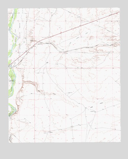
Acme, NM USGS Topographic Map
Click on map above to begin viewing in our Map Viewer.

This topographic map contains these locations and features:
Feature Name Type Latitude Longitude GNIS ID View Map
06222 Water WellWellN33.5457°W104.3075°928426View Map
06234 Water WellWellN33.6118°W104.2922°928428View Map
06235 Water WellWellN33.6106°W104.2927°925019View Map
06236 Water WellWellN33.5981°W104.2937°925018View Map
06237 Water WellWellN33.5732°W104.3323°925015View Map
06238 Water WellWellN33.5832°W104.3128°925016View Map
10798 Water WellWellN33.6215°W104.3250°928429View Map
10799 Water WellWellN33.5979°W104.3269°925017View Map
10822 Water WellWellN33.5457°W104.3469°928427View Map
10827 Water WellWellN33.5323°W104.3311°928425View Map
AcmePopulated PlaceN33.5923°W104.3286°898616View Map
Acme Post Office (historical)Post OfficeN33.5923°W104.3286°937732View Map
Bob Crosby BridgeBridgeN33.5720°W104.3739°928884View Map
Bob Crosby DrawValleyN33.5979°W104.3630°886551View Map
Dallas RanchLocaleN33.5095°W104.3294°888185View Map
Frazier (historical)Populated PlaceN33.5979°W104.3325°920214View Map
Frazier (historical)SchoolN33.5979°W104.3325°920358View Map
Frazier CemeteryCemeteryN33.5977°W104.3332°889225View Map
Frazier Post Office (historical)Post OfficeN33.5979°W104.3325°938442View Map
Hurford PitMineN33.5704°W104.3575°917765View Map
Jesse E Hite PitMineN33.6054°W104.3539°917759View Map
Kitchen RanchLocaleN33.5743°W104.3325°890730View Map
Lloyds CanyonValleyN33.5526°W104.3639°891225View Map
North WindmillLocaleN33.5831°W104.3127°892727View Map
Plaster PlantMineN33.5912°W104.3269°917768View Map
Smith RanchLocaleN33.5287°W104.2797°894940View Map
South WindmillLocaleN33.5462°W104.3080°895189View Map

Note: Coordinates in the location and feature list above are referenced to NAD83 datum.


Copyright (C) 2008-2024 Ryan Niemi / Sunset Dynamics ... All Rights Reserved