TopoQuest Logo
Do you find TopoQuest useful?
Help keep TopoQuest running and adding new maps/features by donating!
Bitcoin:  19c7KJd3qBynnjoSw5npx9KScwjBe4ifkT
Litecoin:  LXs6TkuXGGXo1vDsWCkWVdjQX94eUKd6ui
Home View Maps Find Maps Find Places Resources & Links


Cotton Plant, Florida Topographic Map

USGS Map Title: Cotton Plant, FL
USGS Map MRC: 29082B3
DRG (GeoTIFF) Download: o29082b3.tif


Neighboring USGS Topographic Map Quads:


  Morriston, FL  
29082C4
 

  Fairfield, FL  
29082C3
 

  Reddick, FL  
29082C2
 

  Romeo, FL  
29082B4
 

  Cotton Plant, FL  
29082B3
 

  Ocala West, FL  
29082B2
 

  Dunnellon, FL  
29082A4
 

  Dunnellon SE, FL  
29082A3
 

  Shady, FL  
29082A2


Map MRC Location:

N30°
W83°
N30°
W82°
H8 H7 H6 H5 H4 H3 H2 H1
G8 G7 G6 G5 G4 G3 G2 G1
F8 F7 F6 F5 F4 F3 F2 F1
E8 E7 E6 E5 E4 E3 E2 E1
D8 D7 D6 D5 D4 D3 D2 D1
C8 C7 C6 C5 C4 C3 C2 C1
B8 B7 B6 B5 B4 B3 B2 B1
A8 A7 A6 A5 A4 A3 A2 A1
N29°
W83°
N29°
W82°

Cotton Plant, FL USGS 1:24K Topographic Map Preview:
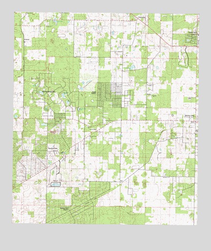
Cotton Plant, FL USGS Topographic Map
Click on map above to begin viewing in our Map Viewer.

This topographic map contains these locations and features:
Feature Name Type Latitude Longitude GNIS ID View Map
Alltel Cellular Phone TowerTowerN29.1444°W82.3398°2053730View Map
Bird PondLakeN29.1973°W82.3385°278830View Map
Blessed Trinity Catholic ChurchChurchN29.1876°W82.3041°2451303View Map
Carter PondLakeN29.2177°W82.2949°280085View Map
Classic Mile Race TrackParkN29.1483°W82.3457°304763View Map
Coleman PondLakeN29.2013°W82.3412°280645View Map
Cotton PlantPopulated PlaceN29.1803°W82.3184°294211View Map
Countryside Baptist ChurchChurchN29.1858°W82.3101°304769View Map
Crosswind Farm AirportAirportN29.2434°W82.3537°309737View Map
Early BirdPopulated PlaceN29.2158°W82.3676°295250View Map
FellowshipPopulated PlaceN29.2472°W82.2920°294764View Map
Fellowship Baptist ChurchChurchN29.2470°W82.2927°2451318View Map
Fellowship Baptist ChurchChurchN29.1864°W82.2526°301193View Map
Fellowship DivisionCivilN29.1800°W82.3298°1935763View Map
Friendship Church (historical)ChurchN29.1869°W82.2512°294602View Map
Gospel Fellowship Outreach Church (historical)ChurchN29.1864°W82.3436°2100776View Map
Hog PondLakeN29.2450°W82.3459°284105View Map
Jude PondLakeN29.1943°W82.3519°284954View Map
Kingdom Hall of Jehovah's WitnessesChurchN29.1953°W82.3001°2053610View Map
Leroy (historical)Populated PlaceN29.1344°W82.3295°295405View Map
Little PondLakeN29.2075°W82.3590°285765View Map
Marion County Fire Rescue Station 12 Meadowood FarmsBuildingN29.1884°W82.3022°2644145View Map
Mars Hill Missionary Baptist ChurchChurchN29.2494°W82.3659°2053609View Map
Minehead StationLocaleN29.2294°W82.3684°303926View Map
Mount OlivePopulated PlaceN29.2016°W82.2848°295468View Map
New Jerusalem Missionary Baptist ChurchChurchN29.1530°W82.2693°301224View Map
Ocala EstatesPopulated PlaceN29.2022°W82.3095°308566View Map
Ocala Pentecostal Church of God in ChristChurchN29.1864°W82.3436°2100777View Map
Our Lady of Guadalupe Catholic ChurchChurchN29.1875°W82.3037°2053611View Map
Rainbow ParkPopulated PlaceN29.1669°W82.3743°303886View Map
Saint Johns United Methodist CemeteryCemeteryN29.1830°W82.3248°304767View Map
Saint Johns United Methodist ChurchChurchN29.1830°W82.3243°304768View Map
Saint Pauls CemeteryCemeteryN29.2080°W82.2826°304772View Map
Saint Pauls ChurchChurchN29.2016°W82.2809°304771View Map
Sanders PondLakeN29.2024°W82.3554°290596View Map
Schoolhouse PondLakeN29.1930°W82.3307°290753View Map
Sherman OaksPopulated PlaceN29.1897°W82.2559°304770View Map
Siloam Baptist ChurchChurchN29.2244°W82.3329°291107View Map
Sonshine Baptist Church (historical)CemeteryN29.1864°W82.3437°304766View Map
Sturgis PrairieFlatN29.2091°W82.3240°291763View Map
Wesley CemeteryCemeteryN29.1766°W82.3229°304764View Map
Wesley ChapelChurchN29.1772°W82.3229°304765View Map
West Marion Baptist ChurchChurchN29.2472°W82.2862°304773View Map
YorkPopulated PlaceN29.1503°W82.3001°295722View Map

Note: Coordinates in the location and feature list above are referenced to NAD83 datum.


Copyright (C) 2008-2024 Ryan Niemi / Sunset Dynamics ... All Rights Reserved