TopoQuest Logo
Do you find TopoQuest useful?
Help keep TopoQuest running and adding new maps/features by donating!
Bitcoin:  19c7KJd3qBynnjoSw5npx9KScwjBe4ifkT
Litecoin:  LXs6TkuXGGXo1vDsWCkWVdjQX94eUKd6ui
Home View Maps Find Maps Find Places Resources & Links


Coal City, Indiana Topographic Map

USGS Map Title: Coal City, IN
USGS Map MRC: 39087B1
DRG (GeoTIFF) Download: o39087b1.tif


Neighboring USGS Topographic Map Quads:


  Saline City, IN  
39087C2
 

  Clay City, IN  
39087C1
 

  Patricksburg, IN  
39086C8
 

  Jasonville, IN  
39087B2
 

  Coal City, IN  
39087B1
 

  Arney, IN  
39086B8
 

  Linton, IN  
39087A2
 

  Switz City, IN  
39087A1
 

  Bloomfield, IN  
39086A8


Map MRC Location:

N40°
W88°
N40°
W87°
H8 H7 H6 H5 H4 H3 H2 H1
G8 G7 G6 G5 G4 G3 G2 G1
F8 F7 F6 F5 F4 F3 F2 F1
E8 E7 E6 E5 E4 E3 E2 E1
D8 D7 D6 D5 D4 D3 D2 D1
C8 C7 C6 C5 C4 C3 C2 C1
B8 B7 B6 B5 B4 B3 B2 B1
A8 A7 A6 A5 A4 A3 A2 A1
N39°
W88°
N39°
W87°

Coal City, IN USGS 1:24K Topographic Map Preview:
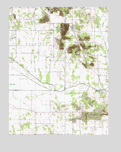
Coal City, IN USGS Topographic Map
Click on map above to begin viewing in our Map Viewer.

This topographic map contains these locations and features:
Feature Name Type Latitude Longitude GNIS ID View Map
Barton CemeteryCemeteryN39.1620°W87.0267°430548View Map
Bohley CemeteryCemeteryN39.1614°W87.1142°431300View Map
BrunswickPopulated PlaceN39.1970°W87.1200°431671View Map
Bullerman CemeteryCemeteryN39.2439°W87.0300°431800View Map
Bunnell BranchStreamN39.1253°W87.0183°431815View Map
Bush CemeteryCemeteryN39.2042°W87.0269°431889View Map
Campbell CemeteryCemeteryN39.1479°W87.0642°432077View Map
Coal CityPopulated PlaceN39.2303°W87.0458°432702View Map
Coal City Community Volunteer Fire DepartmentBuildingN39.2309°W87.0450°2626383View Map
DaggettPopulated PlaceN39.2156°W87.0389°433281View Map
Duncan CemeteryCemeteryN39.2056°W87.0883°433770View Map
Fiscus CemeteryCemeteryN39.2264°W87.0011°434503View Map
Fuller CemeteryCemeteryN39.1257°W87.0494°434892View Map
Hauser CreekStreamN39.2275°W87.0097°435886View Map
Hope ChurchChurchN39.2203°W87.1167°436437View Map
Howesville DitchCanalN39.1564°W87.1228°436556View Map
HubbellPopulated PlaceN39.1831°W87.0122°436560View Map
JohnstownPopulated PlaceN39.1667°W87.0089°437069View Map
Kisling CreekStreamN39.2356°W87.1036°437364View Map
Lagoon CreekStreamN39.1720°W87.0233°437510View Map
Lincoln ChurchChurchN39.1250°W87.0920°437906View Map
Little John CemeteryCemeteryN39.2006°W87.0000°438084View Map
Mount Vernon ChurchChurchN39.1478°W87.0311°439721View Map
Muir LakeLakeN39.1743°W87.1220°439865View Map
Neihart CemeteryCemeteryN39.2367°W87.0328°439988View Map
New BrunswickPopulated PlaceN39.2059°W87.1214°452131View Map
Pond CreekStreamN39.1753°W87.0756°441424View Map
Providence ChurchChurchN39.1256°W87.1197°441621View Map
Scafford Prairie CemeteryCemeteryN39.1259°W87.0678°443054View Map
Sink CemeteryCemeteryN39.2459°W87.1236°443549View Map
Stanley CemeteryCemeteryN39.1478°W87.0173°444062View Map
Steward CemeteryCemeteryN39.1525°W87.0311°444143View Map
StocktonPopulated PlaceN39.2389°W87.0222°444183View Map
Susan Brothers CreekStreamN39.2003°W87.1225°444439View Map
Tapawingo LakeReservoirN39.2297°W87.0623°444574View Map
Township of SmithCivilN39.1251°W87.0824°453851View Map
Turkey CreekStreamN39.1725°W87.0439°444963View Map
White Oak CreekStreamN39.1773°W87.0853°445952View Map
Whorley DitchCanalN39.2342°W87.0872°445999View Map
Wilson CemeteryCemeteryN39.2098°W87.0645°446128View Map
Winters CemeteryCemeteryN39.1986°W87.0478°446195View Map

Note: Coordinates in the location and feature list above are referenced to NAD83 datum.


Copyright (C) 2008-2024 Ryan Niemi / Sunset Dynamics ... All Rights Reserved