TopoQuest Logo
Do you find TopoQuest useful?
Help keep TopoQuest running and adding new maps/features by donating!
Bitcoin:  19c7KJd3qBynnjoSw5npx9KScwjBe4ifkT
Litecoin:  LXs6TkuXGGXo1vDsWCkWVdjQX94eUKd6ui
Home View Maps Find Maps Find Places Resources & Links


Worthley Pond, Maine Topographic Map

USGS Map Title: Worthley Pond, ME
USGS Map MRC: 44070D4
DRG (GeoTIFF) Download: o44070d4.tif


Neighboring USGS Topographic Map Quads:


  Rumford, ME  
44070E5
 

  Dixfield, ME  
44070E4
 

  East Dixfield, ME  
44070E3
 

  Mount Zircon, ME  
44070D5
 

  Worthley Pond, ME  
44070D4
 

  Canton, ME  
44070D3
 

  West Paris, ME  
44070C5
 

  West Sumner, ME  
44070C4
 

  Buckfield, ME  
44070C3


Map MRC Location:

N45°
W71°
N45°
W70°
H8 H7 H6 H5 H4 H3 H2 H1
G8 G7 G6 G5 G4 G3 G2 G1
F8 F7 F6 F5 F4 F3 F2 F1
E8 E7 E6 E5 E4 E3 E2 E1
D8 D7 D6 D5 D4 D3 D2 D1
C8 C7 C6 C5 C4 C3 C2 C1
B8 B7 B6 B5 B4 B3 B2 B1
A8 A7 A6 A5 A4 A3 A2 A1
N44°
W71°
N44°
W70°

Worthley Pond, ME USGS 1:24K Topographic Map Preview:
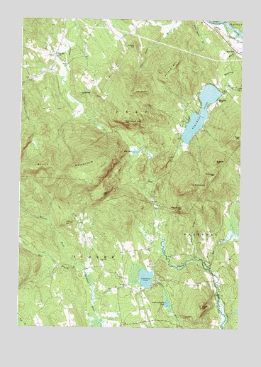
Worthley Pond, ME USGS Topographic Map
Click on map above to begin viewing in our Map Viewer.

This topographic map contains these locations and features:
Feature Name Type Latitude Longitude GNIS ID View Map
Allen MountainSummitN44.4292°W70.4531°561192View Map
Benson HillSummitN44.4172°W70.4742°562066View Map
Bisbee CemeteryCemeteryN44.3873°W70.4291°2736848View Map
Black MountainSummitN44.4403°W70.4634°562463View Map
Black Mountain CemeteryCemeteryN44.4021°W70.4539°562470View Map
Bog BrookStreamN44.3992°W70.3928°562666View Map
Brackett CemeteryCemeteryN44.4990°W70.4526°2736849View Map
Browns MountainSummitN44.4426°W70.3892°563079View Map
DickvalePopulated PlaceN44.4856°W70.4803°579239View Map
Dickvale CemeteryCemeteryN44.4849°W70.4812°563327View Map
East PeruPopulated PlaceN44.4884°W70.3790°565656View Map
Fields HillSummitN44.3834°W70.3956°566129View Map
Fields Hill CemeteryCemeteryN44.3923°W70.4012°566130View Map
Franklin CemeteryCemeteryN44.4756°W70.4946°2724637View Map
Glover Young CemeteryCemeteryN44.4096°W70.3938°2736360View Map
Hammon CemeteryCemeteryN44.4973°W70.4814°2736364View Map
Hedgehog HillSummitN44.4695°W70.4666°567887View Map
Keene CemeteryCemeteryN44.4068°W70.4267°2736369View Map
Knights HillSummitN44.4892°W70.4359°569251View Map
Knox CemeteryCemeteryN44.4750°W70.4608°2736371View Map
Labrador PondLakeN44.3952°W70.4277°569293View Map
Little Labrador PondLakeN44.3848°W70.4153°569867View Map
Mud PondLakeN44.4465°W70.4338°571895View Map
Oldham CemeteryCemeteryN44.4545°W70.4101°2736382View Map
Peru Fire Department SubstationBuildingN44.4826°W70.3891°2553126View Map
Poland MountainSummitN44.4764°W70.4188°573565View Map
Ragged Jack MountainSummitN44.4236°W70.4074°573964View Map
Russell BrookStreamN44.4031°W70.3989°574604View Map
Russell BrookStreamN44.4003°W70.4642°574605View Map
SumnerPopulated PlaceN44.3920°W70.4384°579755View Map
Sumner Post OfficePost OfficeN44.3782°W70.4242°2768920View Map
Sumner Volunteer Fire DepartmentBuildingN44.3783°W70.4233°2552835View Map
The PinnacleSummitN44.4705°W70.4358°576898View Map
The SaddlebackSummitN44.4328°W70.3948°576915View Map
Thomas BrookStreamN44.4748°W70.3837°576982View Map
Thompson MountainSummitN44.4373°W70.3894°577018View Map
Town of PeruCivilN44.4735°W70.4506°582673View Map
Tumbledown Dick MountainSummitN44.4584°W70.4411°577397View Map
Waite CemeteryCemeteryN44.4975°W70.4354°2736906View Map
Worthley PondReservoirN44.4628°W70.3980°578709View Map
Worthley PondPopulated PlaceN44.4681°W70.3884°578710View Map
Worthley Pond DamDamN44.4708°W70.3860°1774282View Map

Note: Coordinates in the location and feature list above are referenced to NAD83 datum.


Copyright (C) 2008-2024 Ryan Niemi / Sunset Dynamics ... All Rights Reserved