TopoQuest Logo
Do you find TopoQuest useful?
Help keep TopoQuest running and adding new maps/features by donating!
Bitcoin:  19c7KJd3qBynnjoSw5npx9KScwjBe4ifkT
Litecoin:  LXs6TkuXGGXo1vDsWCkWVdjQX94eUKd6ui
Home View Maps Find Maps Find Places Resources & Links


Mermet, Illinois Topographic Map

USGS Map Title: Mermet, IL
USGS Map MRC: 37088C7
DRG (GeoTIFF) Download: o37088c7.tif


Neighboring USGS Topographic Map Quads:


  Vienna, IL  
37088D8
 

  Bloomfield, IL  
37088D7
 

  Glendale, IL  
37088D6
 

  Karnak, IL  
37088C8
 

  Mermet, IL  
37088C7
 

  Reevesville, IL  
37088C6
 

  Bandana, KY  
37088B8
 

  Joppa, IL  
37088B7
 

  Metropolis, IL  
37088B6


Map MRC Location:

N38°
W89°
N38°
W88°
H8 H7 H6 H5 H4 H3 H2 H1
G8 G7 G6 G5 G4 G3 G2 G1
F8 F7 F6 F5 F4 F3 F2 F1
E8 E7 E6 E5 E4 E3 E2 E1
D8 D7 D6 D5 D4 D3 D2 D1
C8 C7 C6 C5 C4 C3 C2 C1
B8 B7 B6 B5 B4 B3 B2 B1
A8 A7 A6 A5 A4 A3 A2 A1
N37°
W89°
N37°
W88°

Mermet, IL USGS 1:24K Topographic Map Preview:
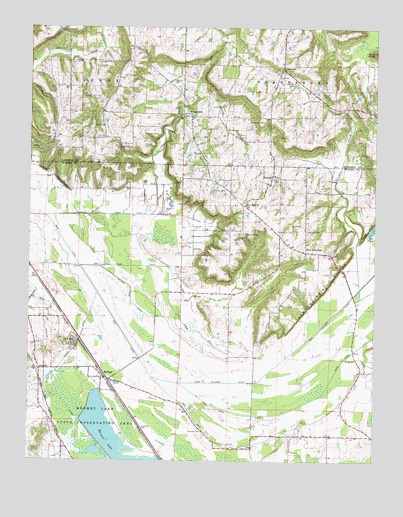
Mermet, IL USGS Topographic Map
Click on map above to begin viewing in our Map Viewer.

This topographic map contains these locations and features:
Feature Name Type Latitude Longitude GNIS ID View Map
Berea ChurchChurchN37.3464°W88.8487°404203View Map
Berea School (historical)SchoolN37.3609°W88.8612°1815825View Map
Black Hill School (historical)SchoolN37.2945°W88.8026°1821504View Map
Blue KnobSummitN37.3678°W88.7509°404594View Map
Bucker Pond DitchCanalN37.2964°W88.8384°405108View Map
Burnham CemeteryCemeteryN37.3156°W88.7973°405237View Map
Cagle CemeteryCemeteryN37.3312°W88.7853°405336View Map
Carr CemeteryCemeteryN37.3184°W88.7770°405627View Map
Central CemeteryCemeteryN37.3478°W88.7909°405853View Map
Central School (historical)SchoolN37.3462°W88.7917°1815837View Map
Clendenon CemeteryCemeteryN37.3164°W88.7853°406243View Map
Clifty CreekStreamN37.3212°W88.8312°406256View Map
Clifty Creek DitchCanalN37.3209°W88.8453°406258View Map
Clifty Creek School (historical)SchoolN37.3278°W88.8476°1821512View Map
Clymore CemeteryCemeteryN37.3553°W88.7670°406275View Map
CrossroadsPopulated PlaceN37.3489°W88.8176°422591View Map
Curtis CemeteryCemeteryN37.3281°W88.8089°406905View Map
Dry Ridge DitchCanalN37.3026°W88.8245°407432View Map
Ebenezer CemeteryCemeteryN37.3387°W88.7520°407726View Map
Enterprise School (historical)SchoolN37.2542°W88.7942°1821515View Map
Footprint RockPillarN37.3401°W88.8392°408490View Map
GanntownPopulated PlaceN37.3634°W88.7842°408870View Map
Georges CreekStreamN37.3003°W88.7556°408955View Map
Georges Creek Election PrecinctCivilN37.3059°W88.7858°1928501View Map
Glenwood School (historical)SchoolN37.3281°W88.7573°1821525View Map
Grantsburg Number 2 Election PrecinctCivilN37.3572°W88.7652°1928512View Map
Grassy CreekStreamN37.3551°W88.8153°409330View Map
GrinnellPopulated PlaceN37.2792°W88.8723°422763View Map
Main DitchCanalN37.3203°W88.8734°412860View Map
Massonic CemeteryCemeteryN37.3164°W88.7748°1821536View Map
MermetPopulated PlaceN37.2731°W88.8462°413433View Map
Mermet LakeReservoirN37.2551°W88.8489°413434View Map
Mermet Lake State Conservation AreaParkN37.2623°W88.8506°413435View Map
Morgan CemeteryCemeteryN37.3442°W88.8339°413812View Map
New ColumbiaPopulated PlaceN37.3106°W88.7753°414389View Map
New Columbia BluffsCliffN37.3006°W88.7676°414390View Map
New Columbia DitchCanalN37.2939°W88.7626°414391View Map
New Hope ChurchChurchN37.3239°W88.7973°414416View Map
Nineveh CemeteryCemeteryN37.2589°W88.8123°414530View Map
Oakland School (historical)SchoolN37.3570°W88.8340°1815881View Map
Pleasant Union School (historical)SchoolN37.2720°W88.7573°1821557View Map
Q DitchCanalN37.2545°W88.8303°416297View Map
Rentfro CemeteryCemeteryN37.3584°W88.7795°416538View Map
Risinger SpurLocaleN37.2517°W88.8270°1821560View Map
Round Lake (historical)LakeN37.2584°W88.8460°1821562View Map
SamothPopulated PlaceN37.3328°W88.7876°417916View Map
Scoggins CemeteryCemeteryN37.3648°W88.8509°418131View Map
Sen Beck DitchCanalN37.2587°W88.7817°418202View Map
Shiloh CemeteryCemeteryN37.3495°W88.8206°418396View Map
Tucker DitchCanalN37.2667°W88.8617°419908View Map
Wymore CemeteryCemeteryN37.3595°W88.8237°421539View Map

Note: Coordinates in the location and feature list above are referenced to NAD83 datum.


Copyright (C) 2008-2024 Ryan Niemi / Sunset Dynamics ... All Rights Reserved