TopoQuest Logo
Do you find TopoQuest useful?
Help keep TopoQuest running and adding new maps/features by donating!
Bitcoin:  19c7KJd3qBynnjoSw5npx9KScwjBe4ifkT
Litecoin:  LXs6TkuXGGXo1vDsWCkWVdjQX94eUKd6ui
Home View Maps Find Maps Find Places Resources & Links


Karnak, Illinois Topographic Map

USGS Map Title: Karnak, IL
USGS Map MRC: 37088C8
DRG (GeoTIFF) Download: o37088c8.tif


Neighboring USGS Topographic Map Quads:


  Mount Pleasant, IL  
37089D1
 

  Vienna, IL  
37088D8
 

  Bloomfield, IL  
37088D7
 

  Cypress, IL  
37089C1
 

  Karnak, IL  
37088C8
 

  Mermet, IL  
37088C7
 

  Olmsted, IL  
37089B1
 

  Bandana, KY  
37088B8
 

  Joppa, IL  
37088B7


Map MRC Location:

N38°
W89°
N38°
W88°
H8 H7 H6 H5 H4 H3 H2 H1
G8 G7 G6 G5 G4 G3 G2 G1
F8 F7 F6 F5 F4 F3 F2 F1
E8 E7 E6 E5 E4 E3 E2 E1
D8 D7 D6 D5 D4 D3 D2 D1
C8 C7 C6 C5 C4 C3 C2 C1
B8 B7 B6 B5 B4 B3 B2 B1
A8 A7 A6 A5 A4 A3 A2 A1
N37°
W89°
N37°
W88°

Karnak, IL USGS 1:24K Topographic Map Preview:
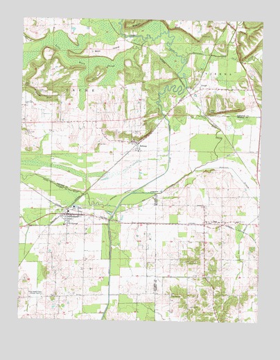
Karnak, IL USGS Topographic Map
Click on map above to begin viewing in our Map Viewer.

This topographic map contains these locations and features:
Feature Name Type Latitude Longitude GNIS ID View Map
Anderson ChurchChurchN37.2978°W88.9042°403509View Map
Anderson School (historical)SchoolN37.2973°W88.9040°1821499View Map
Ash Ridge Post Office (historical)Post OfficeN37.2517°W88.8965°1821500View Map
Bear BranchStreamN37.3606°W88.9962°404007View Map
BelknapPopulated PlaceN37.3251°W88.9390°404115View Map
Belknap Election PrecinctCivilN37.3312°W88.9415°1928444View Map
Belknap Post OfficePost OfficeN37.3239°W88.9400°2788209View Map
Belknap Volunteer Fire DepartmentBuildingN37.3206°W88.9384°2640522View Map
BoazPopulated PlaceN37.2917°W88.8998°404636View Map
Boss IslandIslandN37.3617°W88.9567°404707View Map
Cache River State Natural AreaParkN37.3623°W88.9556°1815832View Map
Cave CreekStreamN37.3606°W88.9020°405717View Map
Cave Creek Glade Nature PreserveParkN37.3587°W88.8853°2013817View Map
Courtney SpurLocaleN37.3103°W88.8792°1821513View Map
Cypress Lookout TowerTowerN37.3445°W88.9917°424803View Map
Dutchman CreekStreamN37.3578°W88.9151°407542View Map
FormanPopulated PlaceN37.3467°W88.9073°422706View Map
George BluffCliffN37.3420°W88.9892°408948View Map
Greenbrier School (historical)SchoolN37.3364°W88.9609°1815853View Map
Hairy HillSummitN37.3498°W88.9651°409619View Map
Heron Pond PreserveParkN37.3584°W88.9215°1815861View Map
Hill CemeteryCemeteryN37.2712°W88.9662°410250View Map
Indian PointCliffN37.3367°W88.9031°410873View Map
KarnakPopulated PlaceN37.2937°W88.9753°411312View Map
Karnak Election PrecinctCivilN37.2847°W88.9742°1928550View Map
Karnak Post OfficePost OfficeN37.2944°W88.9753°2788591View Map
Karnak Volunteer Fire DepartmentBuildingN37.2935°W88.9801°2640283View Map
Lincoln Green Post Office (historical)Post OfficeN37.3284°W88.9973°1815868View Map
Little Black SloughSwampN37.3578°W88.9744°412288View Map
Little Black Slough Nature PreserveParkN37.3537°W88.9662°1815869View Map
Logan Election PrecinctCivilN37.2872°W88.8755°1928559View Map
Logan School Number 6SchoolN37.2912°W88.8876°425142View Map
Lower Salem ChurchChurchN37.2612°W88.9201°412719View Map
Masonic CemeteryCemeteryN37.3281°W88.9417°1815873View Map
Miller CemeteryCemeteryN37.3231°W88.9601°413569View Map
Old Cache RiverStreamN37.2976°W88.9487°414996View Map
Patterson BranchStreamN37.3012°W88.8751°415441View Map
Post Creek School (historical)SchoolN37.2795°W88.9337°1725644View Map
Scanlin SpurLocaleN37.3664°W88.9467°1815894View Map
Swan Lake School (historical)SchoolN37.2595°W88.9781°1725648View Map
Township of Cache (historical)CivilN37.3626°W88.9876°1796502View Map
Union School (historical)SchoolN37.2687°W88.9081°1821569View Map
Village of BelknapCivilN37.3224°W88.9405°2398072View Map
Village of KarnakCivilN37.2942°W88.9758°2398329View Map
West Eden CemeteryCemeteryN37.3273°W88.9984°420818View Map
West Eden ChurchChurchN37.3395°W88.9981°420819View Map
West Eden School (historical)SchoolN37.3398°W88.9973°1815915View Map
Wildcat BluffCliffN37.3737°W88.9267°421143View Map
Wildcat CemeteryCemeteryN37.3689°W88.9073°421145View Map

Note: Coordinates in the location and feature list above are referenced to NAD83 datum.


Copyright (C) 2008-2024 Ryan Niemi / Sunset Dynamics ... All Rights Reserved