TopoQuest Logo
Do you find TopoQuest useful?
Help keep TopoQuest running and adding new maps/features by donating!
Bitcoin:  19c7KJd3qBynnjoSw5npx9KScwjBe4ifkT
Litecoin:  LXs6TkuXGGXo1vDsWCkWVdjQX94eUKd6ui
Home View Maps Find Maps Find Places Resources & Links


Barela, Colorado Topographic Map

USGS Map Title: Barela, CO
USGS Map MRC: 37104A3
DRG (GeoTIFF) Download: o37104a3.tif


Neighboring USGS Topographic Map Quads:


  Trinidad East, CO  
37104B4
 

  Mooney Hills, CO  
37104B3
 

  Patterson Crossing, CO  
37104B2
 

  Fishers Peak, CO  
37104A4
 

  Barela, CO  
37104A3
 

  Abeyta, CO  
37104A2
 

  Raton, NM  
36104H4
 

  Yankee, NM  
36104H3
 

  Dale Mountain, NM  
36104H2


Map MRC Location:

N38°
W105°
N38°
W104°
H8 H7 H6 H5 H4 H3 H2 H1
G8 G7 G6 G5 G4 G3 G2 G1
F8 F7 F6 F5 F4 F3 F2 F1
E8 E7 E6 E5 E4 E3 E2 E1
D8 D7 D6 D5 D4 D3 D2 D1
C8 C7 C6 C5 C4 C3 C2 C1
B8 B7 B6 B5 B4 B3 B2 B1
A8 A7 A6 A5 A4 A3 A2 A1
N37°
W105°
N37°
W104°

Barela, CO USGS 1:24K Topographic Map Preview:
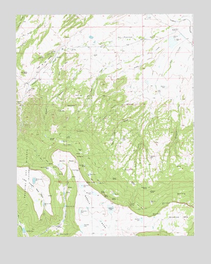
Barela, CO USGS Topographic Map
Click on map above to begin viewing in our Map Viewer.

This topographic map contains these locations and features:
Feature Name Type Latitude Longitude GNIS ID View Map
Archibald Upper DitchCanalN37.1032°W104.3464°2711015View Map
BarelaPopulated PlaceN37.1156°W104.2616°194884View Map
Barela CemeteryCemeteryN37.1103°W104.2625°194886View Map
Bathtub SpringSpringN37.0550°W104.3514°194891View Map
Big LakeReservoirN37.0539°W104.3432°194893View Map
Burro MesaSummitN37.0477°W104.3447°194894View Map
CaņoncitoValleyN37.1161°W104.3614°194874View Map
Demchek LakeLakeN37.0093°W104.2876°194936View Map
Dick Messer SpringSpringN37.0400°W104.3266°194916View Map
Didero SpringSpringN37.0214°W104.3080°194922View Map
Dominguez LakeLakeN37.0288°W104.3298°194918View Map
Dripping SpringSpringN37.0250°W104.2811°194931View Map
Dry CreekStreamN37.0697°W104.2841°194938View Map
Dussar SpringSpringN37.0322°W104.3075°194924View Map
East Fork Schwachheim CreekStreamN37.0070°W104.3719°194877View Map
Hermosa DamReservoirN37.1114°W104.2636°194885View Map
Hermosa Valley ReservoirReservoirN37.1091°W104.2647°199147View Map
Hoffman LakeLakeN37.0156°W104.3089°194928View Map
Horseshoe MesaFlatN37.0178°W104.2555°203742View Map
Jamieson LakeLakeN37.0059°W104.3293°194929View Map
Julius ParksFlatN37.0164°W104.2891°194933View Map
Laguna NegraLakeN37.0518°W104.3367°194895View Map
Lake DorotheyReservoirN37.0036°W104.3703°194911View Map
Lake in the HoleLakeN37.0378°W104.2993°194923View Map
Lantin LakeReservoirN37.0549°W104.3069°194899View Map
Largo CanyonValleyN37.1037°W104.3462°194879View Map
Loma de la CruzRidgeN37.0886°W104.3453°194882View Map
Loma de los ConejosRidgeN37.0947°W104.3608°194881View Map
Loma MujerSummitN37.0924°W104.3701°194880View Map
Mararski LakeLakeN37.0244°W104.3210°194919View Map
Mararski MineMineN37.0595°W104.3328°194898View Map
Martinez ParkFlatN37.0197°W104.2805°194932View Map
McCoy CanyonValleyN37.0758°W104.3706°194875View Map
Medina CanyonValleyN37.0743°W104.2991°194902View Map
Medina LakeLakeN37.0741°W104.2978°194896View Map
Mesita NegraSummitN37.0740°W104.3332°194897View Map
Messer FlatFlatN37.0495°W104.3311°194903View Map
Monique SpringSpringN37.0303°W104.3200°194917View Map
Negro SpringSpringN37.0228°W104.3136°194921View Map
Nick SpringSpringN37.0561°W104.3375°194892View Map
Ocaņa CreekStreamN37.1145°W104.2511°194887View Map
Ojo NegroSpringN37.0709°W104.3447°194890View Map
Ojo Negro CanyonValleyN37.1033°W104.2790°194888View Map
Paula SpringSpringN37.0250°W104.3136°194920View Map
Pete SpringSpringN37.0450°W104.3280°194901View Map
Petes LakeReservoirN37.0548°W104.3008°194900View Map
Raton Ski BasinBasinN37.0053°W104.3467°194913View Map
Right Hand CanyonValleyN37.0731°W104.2808°194904View Map
Roberts PondReservoirN37.0838°W104.2693°194889View Map
Roberts Spring Number 1SpringN37.0234°W104.2622°194935View Map
Roberts Spring Number 2SpringN37.0184°W104.2728°194934View Map
Roberts Spring Number 3SpringN37.0122°W104.2794°194937View Map
San Francisco PassGapN37.0389°W104.3516°194907View Map
Sandoval DitchCanalN37.1110°W104.3097°2724196View Map
Sandy Kerr LakeLakeN37.0146°W104.3305°194927View Map
Seavarda LakeReservoirN37.0446°W104.2813°194906View Map
Seavarda SpringsSpringN37.0170°W104.2955°194926View Map
Snyder CanyonValleyN37.0847°W104.3379°194883View Map
Strasia MeadowFlatN37.0295°W104.2939°194925View Map
Timberline SpringSpringN37.0272°W104.2833°194930View Map
Vega LargaLakeN37.0350°W104.3236°194915View Map
Walton Detention Number 1 DamDamN37.0217°W104.3455°199166View Map
Walton Detention Reservoir Number 1ReservoirN37.0217°W104.3455°199167View Map
Walton Lake Number 1ReservoirN37.0015°W104.3457°194912View Map
Walton Lake Number 2ReservoirN37.0172°W104.3411°194910View Map
Walton Lake Number 3ReservoirN37.0184°W104.3562°194909View Map
Walton Lake Number 4LakeN37.0318°W104.3629°194908View Map

Note: Coordinates in the location and feature list above are referenced to NAD83 datum.


Copyright (C) 2008-2024 Ryan Niemi / Sunset Dynamics ... All Rights Reserved