TopoQuest Logo
Do you find TopoQuest useful?
Help keep TopoQuest running and adding new maps/features by donating!
Bitcoin:  19c7KJd3qBynnjoSw5npx9KScwjBe4ifkT
Litecoin:  LXs6TkuXGGXo1vDsWCkWVdjQX94eUKd6ui
Home View Maps Find Maps Find Places Resources & Links


Yankee, New Mexico Topographic Map

USGS Map Title: Yankee, NM
USGS Map MRC: 36104H3
DRG (GeoTIFF) Download: o36104h3.tif


Neighboring USGS Topographic Map Quads:


  Fishers Peak, CO  
37104A4
 

  Barela, CO  
37104A3
 

  Abeyta, CO  
37104A2
 

  Raton, NM  
36104H4
 

  Yankee, NM  
36104H3
 

  Dale Mountain, NM  
36104H2
 

  Clifton House, NM  
36104G4
 

  Hunter Mesa, NM  
36104G3
 

  Johnson Park, NM  
36104G2


Map MRC Location:

N37°
W105°
N37°
W104°
H8 H7 H6 H5 H4 H3 H2 H1
G8 G7 G6 G5 G4 G3 G2 G1
F8 F7 F6 F5 F4 F3 F2 F1
E8 E7 E6 E5 E4 E3 E2 E1
D8 D7 D6 D5 D4 D3 D2 D1
C8 C7 C6 C5 C4 C3 C2 C1
B8 B7 B6 B5 B4 B3 B2 B1
A8 A7 A6 A5 A4 A3 A2 A1
N36°
W105°
N36°
W104°

Yankee, NM USGS 1:24K Topographic Map Preview:
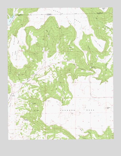
Yankee, NM USGS Topographic Map
Click on map above to begin viewing in our Map Viewer.

This topographic map contains these locations and features:
Feature Name Type Latitude Longitude GNIS ID View Map
Barela MesaSummitN36.9997°W104.3139°1744573View Map
Block Coal Mine Number TwoMineN36.9797°W104.3044°916518View Map
Brides PocketValleyN36.9311°W104.3153°886729View Map
CarisbrookPopulated PlaceN36.9170°W104.3714°902196View Map
Carisbrook Post Office (historical)Post OfficeN36.9170°W104.3714°938133View Map
Davis MineMineN36.9384°W104.3519°916096View Map
DentonLocaleN36.9600°W104.3355°928367View Map
Denton MineMineN36.9617°W104.3405°916504View Map
East Fork Chicorica CreekStreamN36.9175°W104.3692°888655View Map
EvansLocaleN36.9070°W104.3075°928328View Map
Franks MineMineN36.9734°W104.3278°916496View Map
GuerraLocaleN36.9095°W104.3164°928335View Map
Hartzel MineMineN36.9445°W104.3750°916486View Map
Harvey-Genta MineMineN36.9481°W104.2808°916487View Map
Hobbs MineMineN36.9050°W104.3428°916490View Map
Horse Coal MineMineN36.9067°W104.3400°916116View Map
Horse MesaSummitN36.9917°W104.3436°899676View Map
Horse Shoe MesaSummitN36.9659°W104.2655°928309View Map
Johnson MesaSummitN36.9120°W104.3289°890505View Map
Klantchnik MineMineN36.9606°W104.3014°916120View Map
Lake MaloyaReservoirN36.9888°W104.3725°203747View Map
Lake Maloya DamDamN36.9839°W104.3747°924152View Map
Little MesaSummitN36.9611°W104.2628°897397View Map
Llewellyn MineMineN36.9142°W104.3111°916480View Map
M and M MineMineN36.9600°W104.3344°916476View Map
Manco Burro PassGapN36.9434°W104.2772°902294View Map
McClafferty MineMineN36.9361°W104.3219°917890View Map
Mendelsohn MineMineN36.9506°W104.3519°917891View Map
New Yankee Number 4 ClaimMineN36.9656°W104.3405°916519View Map
Newton MineMineN36.9597°W104.2991°917897View Map
Newton-Talbott MineMineN36.9184°W104.3200°917898View Map
Old Honeyfield MineMineN36.9020°W104.3380°917902View Map
Old Latimore MineMineN36.9084°W104.3430°917903View Map
Potato MountainSummitN36.8939°W104.3555°893435View Map
Rathbun CanyonValleyN36.9489°W104.2605°893670View Map
Reynolds MineMineN36.9797°W104.3219°916094View Map
Schwachheim CreekStreamN36.9959°W104.3678°194876View Map
Scoop ProspectMineN36.9361°W104.2683°916097View Map
Sperry MineMineN36.9500°W104.3039°916501View Map
Sugarite CanyonValleyN36.9278°W104.3694°901602View Map
Sugarite MineMineN36.9097°W104.3467°916105View Map
Sunset Coal MineMineN36.9797°W104.3219°916106View Map
Sunshine MineMineN36.9506°W104.3278°916495View Map
Tondrow Peak MineMineN36.9067°W104.2628°916107View Map
Towndrow (historical)LocaleN36.9047°W104.2586°902042View Map
Towndrow PeakSummitN36.9047°W104.2586°895780View Map
TurnerLocaleN36.9609°W104.3455°928417View Map
Turner MineMineN36.9203°W104.3180°916109View Map
Turner Mine Number TwoMineN36.9567°W104.3422°916110View Map
YankeePopulated PlaceN36.9450°W104.3280°900000View Map
Yankee CanyonValleyN36.9211°W104.3636°896798View Map
Yankee Number Five MineMineN36.8925°W104.3228°939796View Map
Yankee Number Four MineMineN36.8925°W104.3228°939795View Map
Yankee Number One MineMineN36.9567°W104.3422°939869View Map
Yankee Number Three MineMineN36.9567°W104.3422°939794View Map
Yankee Number Two MineMineN36.9567°W104.3422°939870View Map
Yankee Post Office (historical)Post OfficeN36.9450°W104.3280°937659View Map
Yankee-Reynolds ProspectMineN36.9734°W104.3275°916128View Map

Note: Coordinates in the location and feature list above are referenced to NAD83 datum.


Copyright (C) 2008-2024 Ryan Niemi / Sunset Dynamics ... All Rights Reserved