TopoQuest Logo
Do you find TopoQuest useful?
Help keep TopoQuest running and adding new maps/features by donating!
Bitcoin:  19c7KJd3qBynnjoSw5npx9KScwjBe4ifkT
Litecoin:  LXs6TkuXGGXo1vDsWCkWVdjQX94eUKd6ui
Home View Maps Find Maps Find Places Resources & Links


Boulder Mountain, Utah Topographic Map

USGS Map Title: Boulder Mountain, UT
USGS Map MRC: 41111F5
DRG (GeoTIFF) Download: o41111f5.tif


Neighboring USGS Topographic Map Quads:


  Mount Elmer, UT  
41111G6
 

  Temple Peak, UT  
41111G5
 

  Meadowville, UT  
41111G4
 

  Logan Peak, UT  
41111F6
 

  Boulder Mountain, UT  
41111F5
 

  Red Spur Mountain, UT  
41111F4
 

  Porcupine Reservoir, UT  
41111E6
 

  Hardware Ranch, UT  
41111E5
 

  Curtis Ridge, UT  
41111E4


Map MRC Location:

N42°
W112°
N42°
W111°
H8 H7 H6 H5 H4 H3 H2 H1
G8 G7 G6 G5 G4 G3 G2 G1
F8 F7 F6 F5 F4 F3 F2 F1
E8 E7 E6 E5 E4 E3 E2 E1
D8 D7 D6 D5 D4 D3 D2 D1
C8 C7 C6 C5 C4 C3 C2 C1
B8 B7 B6 B5 B4 B3 B2 B1
A8 A7 A6 A5 A4 A3 A2 A1
N41°
W112°
N41°
W111°

Boulder Mountain, UT USGS 1:24K Topographic Map Preview:
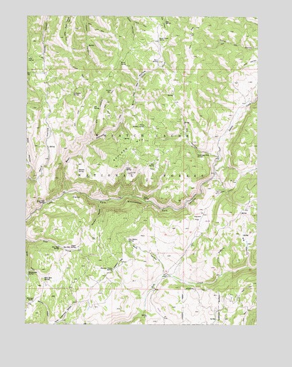
Boulder Mountain, UT USGS Topographic Map
Click on map above to begin viewing in our Map Viewer.

This topographic map contains these locations and features:
Feature Name Type Latitude Longitude GNIS ID View Map
Bear HollowValleyN41.6788°W111.6035°1438475View Map
Bear SpringSpringN41.7320°W111.5546°1438496View Map
Big PeavineValleyN41.6491°W111.5055°1438713View Map
Boar Hole SpringSpringN41.6443°W111.6157°1438975View Map
Boulder MountainSummitN41.6891°W111.5774°1439024View Map
Box SpringSpringN41.7272°W111.6238°1439085View Map
Bronco SpringSpringN41.7202°W111.5813°1439154View Map
Cabin HollowValleyN41.6758°W111.5741°1454697View Map
Cabin SpringSpringN41.6880°W111.5721°1439417View Map
Coldwater SpringSpringN41.7182°W111.6007°1439888View Map
Dip HollowValleyN41.6916°W111.5219°1440465View Map
Dog SpringSpringN41.7476°W111.5510°1440506View Map
Elk HollowValleyN41.6997°W111.5888°1440903View Map
Elk SpringSpringN41.7128°W111.5895°1440912View Map
Gray Cliff SpringSpringN41.6744°W111.6154°1441455View Map
Heber SpringSpringN41.7264°W111.5001°1441663View Map
Humming Bird SpringSpringN41.6935°W111.5337°1441937View Map
Lime SpringSpringN41.6763°W111.5623°1442608View Map
Little PeavineValleyN41.6458°W111.5191°1442757View Map
Lucky Star MineMineN41.6860°W111.5697°1443040View Map
Marie SpringSpringN41.7319°W111.5753°1443194View Map
Mosslander SpringSpringN41.6462°W111.6242°1443617View Map
Mud SpringSpringN41.6907°W111.5567°1443708View Map
Munson HollowValleyN41.6749°W111.5858°1443737View Map
North Boulder SpringSpringN41.7055°W111.5616°1443848View Map
Pine SpringSpringN41.7330°W111.6246°1444410View Map
Pleasant ValleyValleyN41.6469°W111.5772°1444481View Map
Pleasant Valley SpringSpringN41.6475°W111.5787°1444484View Map
Pole HollowValleyN41.6455°W111.5508°1444555View Map
Pole Hollow SpringSpringN41.6588°W111.5706°1444557View Map
Saddle CreekStreamN41.6919°W111.5219°1445222View Map
Seep HollowValleyN41.6844°W111.6247°1445427View Map
Sheep CreekStreamN41.6788°W111.6038°1445489View Map
Sheep Creek SpringSpringN41.7407°W111.5546°1445501View Map
Sidehill SpringSpringN41.6873°W111.5977°1445571View Map
Sow Hole SpringSpringN41.6567°W111.6073°1445943View Map
Squaw FlatFlatN41.6683°W111.5327°1446074View Map
Upper Sow Hole SpringSpringN41.6558°W111.5980°1446880View Map
Warrens HollowValleyN41.6252°W111.6124°1446999View Map
Warrens SpringSpringN41.6342°W111.6219°1447000View Map

Note: Coordinates in the location and feature list above are referenced to NAD83 datum.


Copyright (C) 2008-2024 Ryan Niemi / Sunset Dynamics ... All Rights Reserved