TopoQuest Logo
Do you find TopoQuest useful?
Help keep TopoQuest running and adding new maps/features by donating!
Bitcoin:  19c7KJd3qBynnjoSw5npx9KScwjBe4ifkT
Litecoin:  LXs6TkuXGGXo1vDsWCkWVdjQX94eUKd6ui
Home View Maps Find Maps Find Places Resources & Links


Hardware Ranch, Utah Topographic Map

USGS Map Title: Hardware Ranch, UT
USGS Map MRC: 41111E5
DRG (GeoTIFF) Download: o41111e5.tif


Neighboring USGS Topographic Map Quads:


  Logan Peak, UT  
41111F6
 

  Boulder Mountain, UT  
41111F5
 

  Red Spur Mountain, UT  
41111F4
 

  Porcupine Reservoir, UT  
41111E6
 

  Hardware Ranch, UT  
41111E5
 

  Curtis Ridge, UT  
41111E4
 

  Sharp Mountain, UT  
41111D6
 

  Monte Cristo Peak, UT  
41111D5
 

  Dairy Ridge, UT  
41111D4


Map MRC Location:

N42°
W112°
N42°
W111°
H8 H7 H6 H5 H4 H3 H2 H1
G8 G7 G6 G5 G4 G3 G2 G1
F8 F7 F6 F5 F4 F3 F2 F1
E8 E7 E6 E5 E4 E3 E2 E1
D8 D7 D6 D5 D4 D3 D2 D1
C8 C7 C6 C5 C4 C3 C2 C1
B8 B7 B6 B5 B4 B3 B2 B1
A8 A7 A6 A5 A4 A3 A2 A1
N41°
W112°
N41°
W111°

Hardware Ranch, UT USGS 1:24K Topographic Map Preview:
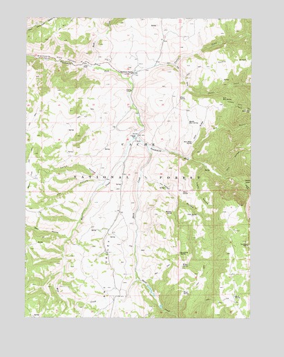
Hardware Ranch, UT USGS Topographic Map
Click on map above to begin viewing in our Map Viewer.

This topographic map contains these locations and features:
Feature Name Type Latitude Longitude GNIS ID View Map
Anderson RanchLocaleN41.5747°W111.5641°1425109View Map
Ant ValleyValleyN41.5749°W111.5841°1438236View Map
Bear HollowValleyN41.5330°W111.6024°1438478View Map
Blacksmith ForkStreamN41.5713°W111.5583°1435159View Map
Boundary SpringSpringN41.5272°W111.5399°1425905View Map
Buck SpringSpringN41.5088°W111.5095°1437283View Map
Burn SpringSpringN41.5523°W111.5387°1426167View Map
Camp WapitiLocaleN41.6052°W111.5908°1426315View Map
Cart HollowValleyN41.5591°W111.5149°1439491View Map
Curtis CreekStreamN41.5997°W111.5685°1440207View Map
Curtis HollowValleyN41.5574°W111.5810°1427168View Map
Deer RidgeRidgeN41.5783°W111.5291°1427318View Map
Deer Ridge SpringSpringN41.5732°W111.5332°1427319View Map
Dry Curtis CreekStreamN41.6058°W111.5430°1440609View Map
Dry GulchValleyN41.5674°W111.5349°1440635View Map
East Mud SpringSpringN41.5908°W111.5169°1427712View Map
Elbow SpringSpringN41.5915°W111.5404°1427777View Map
Fox HollowValleyN41.5560°W111.5835°1428075View Map
Gold HillSummitN41.5863°W111.5013°1428233View Map
Hardware RanchLocaleN41.6019°W111.5658°1428531View Map
Hardware Ranch Game Management AreaParkN41.6183°W111.5791°1455312View Map
Hayes SpringSpringN41.5115°W111.5376°1428606View Map
Johnson DrawValleyN41.5569°W111.5047°1442182View Map
Lions HollowValleyN41.5641°W111.5272°1429657View Map
Middle Mud SpringSpringN41.5819°W111.5357°1430291View Map
Mill CreekStreamN41.5752°W111.5647°1443431View Map
Mollens HollowValleyN41.5569°W111.5047°1443545View Map
Petes HollowValleyN41.5608°W111.5605°1431199View Map
Rock CanyonValleyN41.6074°W111.5888°1448931View Map
Rock CreekStreamN41.6044°W111.5883°1445063View Map
Sheep CreekStreamN41.5713°W111.5574°1445494View Map
Tilda SpringSpringN41.5432°W111.5305°1433523View Map
Whiskey SpringSpringN41.5440°W111.5443°1434153View Map
Wilson SpringSpringN41.5221°W111.5347°1434380View Map

Note: Coordinates in the location and feature list above are referenced to NAD83 datum.


Copyright (C) 2008-2024 Ryan Niemi / Sunset Dynamics ... All Rights Reserved