TopoQuest Logo
Do you find TopoQuest useful?
Help keep TopoQuest running and adding new maps/features by donating!
Bitcoin:  19c7KJd3qBynnjoSw5npx9KScwjBe4ifkT
Litecoin:  LXs6TkuXGGXo1vDsWCkWVdjQX94eUKd6ui
Home View Maps Find Maps Find Places Resources & Links


Winnemucca East, Nevada Topographic Map

USGS Map Title: Winnemucca East, NV
USGS Map MRC: 40117H6
DRG (GeoTIFF) Download: o40117h6.tif


Neighboring USGS Topographic Map Quads:


  Winnemucca Mountain, NV  
41117A7
 

  Weso, NV  
41117A6
 

  Golconda Butte, NV  
41117A5
 

  Winnemucca West, NV  
40117H7
 

  Winnemucca East, NV  
40117H6
 

  Pole Creek, NV  
40117H5
 

  Rose Creek Mountain, NV  
40117G7
 

  Sonoma Canyon, NV  
40117G6
 

  Adelaide, NV  
40117G5


Map MRC Location:

N41°
W118°
N41°
W117°
H8 H7 H6 H5 H4 H3 H2 H1
G8 G7 G6 G5 G4 G3 G2 G1
F8 F7 F6 F5 F4 F3 F2 F1
E8 E7 E6 E5 E4 E3 E2 E1
D8 D7 D6 D5 D4 D3 D2 D1
C8 C7 C6 C5 C4 C3 C2 C1
B8 B7 B6 B5 B4 B3 B2 B1
A8 A7 A6 A5 A4 A3 A2 A1
N40°
W118°
N40°
W117°

Winnemucca East, NV USGS 1:24K Topographic Map Preview:
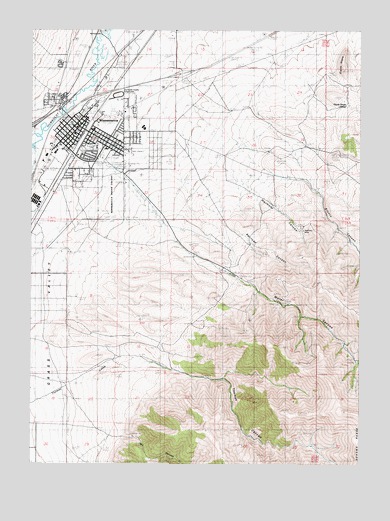
Winnemucca East, NV USGS Topographic Map
Click on map above to begin viewing in our Map Viewer.

This topographic map contains these locations and features:
Feature Name Type Latitude Longitude GNIS ID View Map
Albert M Lowry High SchoolSchoolN40.9760°W117.7135°858622View Map
Centerville (historical)LocaleN40.9860°W117.6915°852061View Map
City of WinnemuccaCivilN40.9645°W117.7246°2412284View Map
Dry CanyonValleyN40.8882°W117.7429°840147View Map
East Winnemucca InterchangeCrossingN40.9877°W117.6946°851993View Map
French Ford Middle SchoolSchoolN40.9678°W117.7069°2076628View Map
Giants GraveSummitN40.9885°W117.6323°849628View Map
Giants Grave SpringSpringN40.9785°W117.6312°849629View Map
Great Basin College Winnemucca Branch CampusSchoolN40.9711°W117.7072°2087576View Map
Harmony CanyonValleyN40.9577°W117.6690°845855View Map
Harmony CreekStreamN40.9946°W117.7082°852163View Map
Harmony Manor Skilled Nursing FacilityHospitalN40.9714°W117.7269°2076201View Map
Harmony MineMineN40.9424°W117.6496°840903View Map
Harmony Mining DistrictCivilN40.8891°W117.6340°855125View Map
Humboldt County Court HouseBuildingN40.9721°W117.7337°847083View Map
Humboldt County FairgroundsLocaleN40.9816°W117.7171°849626View Map
Humboldt General HospitalHospitalN40.9714°W117.7272°852014View Map
Kluncy CanyonValleyN40.9621°W117.6671°848699View Map
KWNA Radio TowerTowerN40.9649°W117.7143°853075View Map
KWNA-AM (Winnemucca)TowerN40.9563°W117.7143°865073View Map
Leighton HallSchoolN40.9751°W117.7311°2095129View Map
Nevada Highway Patrol Northern Command East West Wendover Police SubstationBuildingN40.9540°W117.7489°2740076View Map
Nixon ParkParkN40.9721°W117.7357°846488View Map
North Fork Thomas CreekStreamN40.8999°W117.6785°852280View Map
Pioneer ParkParkN40.9785°W117.7435°852012View Map
Railroad CanyonValleyN40.9563°W117.6937°849630View Map
Raleys PlazaLocaleN40.9649°W117.7421°864324View Map
Reinhart DamDamN40.9986°W117.7244°849627View Map
Saint Pauls Roman Catholic ChurchChurchN40.9730°W117.7357°856995View Map
Sonoma Heights Elementary SchoolSchoolN40.9657°W117.7226°858328View Map
South Fork Thomas CreekStreamN40.8999°W117.6785°852119View Map
Thomas CanyonValleyN40.9032°W117.7024°849631View Map
Valley View Shopping CenterLocaleN40.9627°W117.7465°851687View Map
Water CanyonValleyN40.9355°W117.6915°845726View Map
Whites CreekStreamN40.9638°W117.7251°852120View Map
WinnemuccaPopulated PlaceN40.9730°W117.7357°844996View Map
Winnemucca Boulevard East InterchangeCrossingN40.9810°W117.7282°852015View Map
Winnemucca City HallBuildingN40.9732°W117.7357°852013View Map
Winnemucca City Park and Golf CourseLocaleN40.9718°W117.7224°851994View Map
Winnemucca Elementary SchoolSchoolN40.9699°W117.7343°863993View Map
Winnemucca Fire DepartmentBuildingN40.9746°W117.7221°2581224View Map
Winnemucca Indian ColonyCivilN40.9532°W117.7212°849652View Map
Winnemucca Junior High SchoolSchoolN40.9746°W117.7299°858329View Map
Winnemucca Police DepartmentBuildingN40.9718°W117.7337°2740013View Map
Winnemucca Police DepartmentBuildingN40.9777°W117.7286°2740067View Map
Winnemucca Post OfficePost OfficeN40.9625°W117.7341°864890View Map
Winnemucca Rodeo Grounds (historical)LocaleN40.9646°W117.7424°847082View Map
Winnemucca Rural Fire DepartmentBuildingN40.9730°W117.7327°2581439View Map
Winnemucca Seventh Day Adventist SchoolSchoolN40.9730°W117.7357°857007View Map

Note: Coordinates in the location and feature list above are referenced to NAD83 datum.


Copyright (C) 2008-2024 Ryan Niemi / Sunset Dynamics ... All Rights Reserved