TopoQuest Logo
Do you find TopoQuest useful?
Help keep TopoQuest running and adding new maps/features by donating!
Bitcoin:  19c7KJd3qBynnjoSw5npx9KScwjBe4ifkT
Litecoin:  LXs6TkuXGGXo1vDsWCkWVdjQX94eUKd6ui
Home View Maps Find Maps Find Places Resources & Links


Whitehead, North Carolina Topographic Map

USGS Map Title: Whitehead, NC
USGS Map MRC: 36081D2
DRG (GeoTIFF) Download: o36081d2.tif


Neighboring USGS Topographic Map Quads:


  Mouth of Wilson, VA  
36081E3
 

  Sparta West, NC  
36081E2
 

  Sparta East, NC  
36081E1
 

  Laurel Springs, NC  
36081D3
 

  Whitehead, NC  
36081D2
 

  Glade Valley, NC  
36081D1
 

  Horse Gap, NC  
36081C3
 

  McGrady, NC  
36081C2
 

  Traphill, NC  
36081C1


Map MRC Location:

N37°
W82°
N37°
W81°
H8 H7 H6 H5 H4 H3 H2 H1
G8 G7 G6 G5 G4 G3 G2 G1
F8 F7 F6 F5 F4 F3 F2 F1
E8 E7 E6 E5 E4 E3 E2 E1
D8 D7 D6 D5 D4 D3 D2 D1
C8 C7 C6 C5 C4 C3 C2 C1
B8 B7 B6 B5 B4 B3 B2 B1
A8 A7 A6 A5 A4 A3 A2 A1
N36°
W82°
N36°
W81°

Whitehead, NC USGS 1:24K Topographic Map Preview:
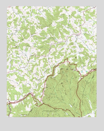
Whitehead, NC USGS Topographic Map
Click on map above to begin viewing in our Map Viewer.

This topographic map contains these locations and features:
Feature Name Type Latitude Longitude GNIS ID View Map
Air Bellows DamDamN36.4351°W81.1281°1000623View Map
Air Bellows GapGapN36.4282°W81.1273°980067View Map
Alleghany CountyCivilN36.4913°W81.1279°1008533View Map
Alligator BackCliffN36.4185°W81.1854°980124View Map
Antioch CemeteryCemeteryN36.4951°W81.1970°1959869View Map
Antioch Primitive Baptist ChurchChurchN36.4954°W81.1970°980251View Map
Basin Coves OverlookLocaleN36.3907°W81.1998°980595View Map
Basin CreekStreamN36.3757°W81.1304°980596View Map
Basin Creek Church (historical)ChurchN36.3907°W81.1629°1959968View Map
Bell KnobSummitN36.3840°W81.1684°1019068View Map
Bell RidgeRidgeN36.3796°W81.1593°980945View Map
Betsy PeakSummitN36.4540°W81.2384°1019117View Map
Bluff MountainSummitN36.4201°W81.1856°1019235View Map
Bluff Mountain OverlookLocaleN36.4085°W81.1954°981647View Map
Bluff RidgeRidgeN36.4079°W81.1704°981650View Map
Brinegar CabinLocaleN36.4187°W81.1456°981911View Map
Brinegar CabinBuildingN36.4187°W81.1456°2057283View Map
Brooks BranchStreamN36.3946°W81.1715°981967View Map
Brooks KnobSummitN36.4129°W81.1745°981979View Map
Camp CreekStreamN36.3965°W81.1359°982522View Map
Catherine KnobSummitN36.4660°W81.2134°1019563View Map
Caudill BranchStreamN36.4090°W81.1623°982777View Map
Caudill CabinLocaleN36.4265°W81.1706°982778View Map
Cedar RidgeRidgeN36.4010°W81.1518°982899View Map
Cheek BranchStreamN36.4587°W81.1776°983065View Map
Cheek Mill (historical)LocaleN36.4640°W81.1931°1959870View Map
Cheek MountainSummitN36.4735°W81.1990°1019611View Map
Civilian Conservation Corps Camp NP-21 (historical)LocaleN36.3912°W81.2048°1959874View Map
Cove CreekStreamN36.3890°W81.1612°983618View Map
Dark HollowValleyN36.3841°W81.1551°983958View Map
Dog BranchStreamN36.4676°W81.1581°1959878View Map
Doughton Recreation AreaParkN36.4060°W81.1743°984302View Map
Elk KnobSummitN36.4096°W81.2423°1020123View Map
Evans BranchStreamN36.4518°W81.1901°984855View Map
Fender MountainSummitN36.4901°W81.1762°1020230View Map
Flat Rock KnobSummitN36.3849°W81.1831°985185View Map
Flat Rock RidgeRidgeN36.3879°W81.1926°985186View Map
Fodder StackSummitN36.4285°W81.1670°985257View Map
Hanging ValleyValleyN36.3858°W81.1546°986365View Map
Joines Mill (historical)LocaleN36.4668°W81.1559°1959896View Map
Joines Mill (historical)LocaleN36.4707°W81.1409°1959897View Map
Landmark Union Baptist ChurchChurchN36.4632°W81.1526°2057280View Map
Laurel Fork ChurchChurchN36.3810°W81.2445°988192View Map
Liberty Missionary Baptist ChurchChurchN36.4624°W81.1526°2057279View Map
Little Grandfather MountainSummitN36.3762°W81.2256°1021190View Map
Lovelace CreekStreamN36.3760°W81.1304°989060View Map
Low NotchGapN36.4326°W81.1634°989083View Map
Maple BranchStreamN36.4307°W81.2273°989300View Map
Meadow Fork Primitive Baptist ChurchChurchN36.3876°W81.2465°1959912View Map
Miller Mill (historical)LocaleN36.3937°W81.2315°1959914View Map
Millers CampingLocaleN36.3976°W81.2270°1007834View Map
NonameReservoirN36.4351°W81.1281°1000622View Map
Peach Bottom MountainSummitN36.4660°W81.2212°991977View Map
Petty Mill (historical)LocaleN36.4229°W81.1970°1959928View Map
Pine ForkPopulated PlaceN36.4437°W81.2170°1959931View Map
Pine Fork Missionary Baptist ChurchChurchN36.4443°W81.2151°992328View Map
Pine MountainSummitN36.4190°W81.2109°1021929View Map
Pleasant GrovePopulated PlaceN36.4174°W81.2051°1959936View Map
Pleasant Grove Baptist ChurchChurchN36.4171°W81.2045°992507View Map
Prathers Creek Baptist ChurchChurchN36.4718°W81.2359°992783View Map
Prathers Creek CemeteryCemeteryN36.4721°W81.2362°1959938View Map
Sheep RockSummitN36.4421°W81.1554°1022577View Map
Stamper CemeteryCemeteryN36.4379°W81.2404°995398View Map
Stern Lake DamDamN36.4268°W81.1398°1000615View Map
The PeakSummitN36.4574°W81.1604°1022925View Map
Township of CranberryCivilN36.4245°W81.2225°1026365View Map
Township of WhiteheadCivilN36.4573°W81.1380°1026370View Map
Union CemeteryCemeteryN36.4640°W81.1459°1959959View Map
Union Primitive Baptist ChurchChurchN36.4674°W81.1526°996469View Map
Waterfalls CreekStreamN36.4646°W81.1534°996848View Map
West Camp BranchStreamN36.3971°W81.1801°996997View Map
WhiteheadPopulated PlaceN36.4674°W81.1529°1023215View Map
Whitehead Community CenterBuildingN36.4696°W81.1562°2057281View Map
Whitehead Union Baptist ChurchChurchN36.4651°W81.1459°2057282View Map
Wildcat BranchStreamN36.4226°W81.1668°997310View Map
Wildcat RockCliffN36.4293°W81.1751°997316View Map
Wildcat Rock Water TowerTowerN36.4296°W81.1748°2057277View Map
Willis LakeReservoirN36.4264°W81.1452°1000617View Map
Willis Lake DamDamN36.4268°W81.1448°1000616View Map

Note: Coordinates in the location and feature list above are referenced to NAD83 datum.


Copyright (C) 2008-2024 Ryan Niemi / Sunset Dynamics ... All Rights Reserved