TopoQuest Logo
Do you find TopoQuest useful?
Help keep TopoQuest running and adding new maps/features by donating!
Bitcoin:  19c7KJd3qBynnjoSw5npx9KScwjBe4ifkT
Litecoin:  LXs6TkuXGGXo1vDsWCkWVdjQX94eUKd6ui
Home View Maps Find Maps Find Places Resources & Links


Bledsoe, Kentucky Topographic Map

USGS Map Title: Bledsoe, KY
USGS Map MRC: 36083H3
DRG (GeoTIFF) Download: o36083h3.tif


Neighboring USGS Topographic Map Quads:


  Hoskinston, KY  
37083A4
 

  Cutshin, KY  
37083A3
 

  Leatherwood, KY  
37083A2
 

  Helton, KY  
36083H4
 

  Bledsoe, KY  
36083H3
 

  Nolansburg, KY  
36083H2
 

  Wallins Creek, KY  
36083G4
 

  Harlan, KY  
36083G3
 

  Evarts, KY  
36083G2


Map MRC Location:

N37°
W84°
N37°
W83°
H8 H7 H6 H5 H4 H3 H2 H1
G8 G7 G6 G5 G4 G3 G2 G1
F8 F7 F6 F5 F4 F3 F2 F1
E8 E7 E6 E5 E4 E3 E2 E1
D8 D7 D6 D5 D4 D3 D2 D1
C8 C7 C6 C5 C4 C3 C2 C1
B8 B7 B6 B5 B4 B3 B2 B1
A8 A7 A6 A5 A4 A3 A2 A1
N36°
W84°
N36°
W83°

Bledsoe, KY USGS 1:24K Topographic Map Preview:
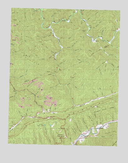
Bledsoe, KY USGS Topographic Map
Click on map above to begin viewing in our Map Viewer.

This topographic map contains these locations and features:
Feature Name Type Latitude Longitude GNIS ID View Map
Abner BranchStreamN36.9726°W83.2782°510200View Map
Abner Branch ChapelChurchN36.9712°W83.2774°510201View Map
Alecs BranchStreamN36.9818°W83.2505°510233View Map
Anna Howard BranchStreamN36.8876°W83.2813°510282View Map
Babs BranchStreamN36.9195°W83.2680°510332View Map
Bear BranchStreamN36.9762°W83.2868°510444View Map
Bear BranchStreamN36.9918°W83.3388°510446View Map
Betseys BranchStreamN36.9009°W83.3543°510577View Map
Big BranchStreamN36.9223°W83.2577°510604View Map
Big Rock Post Office (historical)Post OfficeN36.8836°W83.2615°2565548View Map
Bill BranchStreamN36.9301°W83.3093°510714View Map
BledsoePopulated PlaceN36.9237°W83.3668°510783View Map
Bledsoe ChurchChurchN36.9212°W83.3474°510784View Map
Bledsoe Post Office (historical)Post OfficeN36.9243°W83.3667°2565556View Map
Bledsoe Volunteer Fire Department Station 1BuildingN36.9039°W83.3402°2636824View Map
Blue HollowValleyN36.9824°W83.3592°510802View Map
Britton BranchStreamN36.9995°W83.3396°510932View Map
Buck BranchStreamN36.9515°W83.2638°510991View Map
Buckheart HollowValleyN36.9802°W83.2881°511024View Map
Cawood Recreation SiteLocaleN36.9356°W83.3724°517546View Map
Cedar ChapelChurchN36.9809°W83.2543°511290View Map
Chestnut FlatsFlatN36.8780°W83.3049°2565660View Map
Chumney BranchStreamN36.9254°W83.3557°511364View Map
Cold Spring HollowValleyN36.9887°W83.3671°511461View Map
Daws BranchStreamN36.9187°W83.3452°511744View Map
Della Post Office (historical)Post OfficeN36.9893°W83.3135°2363126View Map
Dollar BranchStreamN36.9893°W83.2882°511861View Map
Dry BranchStreamN36.9806°W83.2535°511904View Map
Dug ForkStreamN36.9965°W83.3593°511945View Map
Eastep HollowValleyN36.9489°W83.3190°511999View Map
English CreekStreamN36.8859°W83.2752°512075View Map
English SpurRidgeN36.8879°W83.2521°512076View Map
Fate ForkStreamN36.9321°W83.2895°2565612View Map
Feds CreekStreamN36.9726°W83.3199°512142View Map
Gabes CreekStreamN36.9701°W83.2610°512271View Map
Gap BranchStreamN36.8854°W83.2823°2565628View Map
Gatun Railroad Station (historical)LocaleN36.8754°W83.3000°2565632View Map
Gray MountainSummitN36.9634°W83.3632°512410View Map
Greasy Creek ChurchChurchN36.9904°W83.3118°2363137View Map
Greasy Creek SchoolSchoolN36.9904°W83.3121°512421View Map
Green CemeteryCemeteryN36.9042°W83.3338°512430View Map
Green Hill CemeteryCemeteryN36.9181°W83.3288°512438View Map
Green Hills Elementary SchoolSchoolN36.8998°W83.3476°512439View Map
Halfmile BranchStreamN36.9654°W83.2710°512510View Map
Hall BranchStreamN36.8904°W83.3677°512516View Map
Hanging RockPillarN36.8904°W83.3130°512545View Map
Harlan County Forestry CampLocaleN36.9098°W83.2760°516623View Map
Hazard GapGapN36.9004°W83.3272°2565651View Map
Hen Shate HollowValleyN36.9908°W83.2935°512645View Map
Henry ForkStreamN36.9587°W83.2621°512657View Map
Holbrook CemeteryCemeteryN36.9109°W83.2941°512737View Map
Holly Bush HollowValleyN36.9734°W83.3581°516625View Map
Howard CemeteryCemeteryN36.8931°W83.2616°512817View Map
Huff CemeteryCemeteryN36.9754°W83.2727°512831View Map
Incline Post Office (historical)Post OfficeN36.9113°W83.2991°2565680View Map
Incline SchoolSchoolN36.9176°W83.2755°512891View Map
Jericho HollowValleyN36.9982°W83.3480°512996View Map
John Miniard BranchStreamN36.9826°W83.2838°513032View Map
Johns BranchStreamN36.9881°W83.3082°513038View Map
Jones CemeteryCemeteryN36.8798°W83.2916°513065View Map
Jonesburg Post Office (historical)Post OfficeN36.8821°W83.2822°2565693View Map
Laurel BranchStreamN36.9465°W83.2527°513228View Map
Laurel ForkStreamN36.9831°W83.3299°513256View Map
Laurel Mission ChurchChurchN36.9820°W83.3197°2362741View Map
Left Fork Bill BranchStreamN36.9323°W83.3057°513304View Map
Lewis CreekPopulated PlaceN36.9895°W83.3168°513363View Map
Lewis CreekStreamN36.9984°W83.2960°513364View Map
Lewis Creek Post Office (historical)Post OfficeN36.9909°W83.3135°2362742View Map
Little Sheppard TrailTrailN36.9018°W83.2988°2565740View Map
Lovely BranchStreamN36.9645°W83.3157°513653View Map
Lower Double BranchStreamN36.9579°W83.3230°513687View Map
Lower Joe ForkStreamN36.9643°W83.3046°497288View Map
Lower Laurel Creek SchoolSchoolN36.9701°W83.3196°513700View Map
McKnightLocaleN36.9113°W83.2990°2565755View Map
Meetinghouse BranchStreamN36.9751°W83.2707°513898View Map
Middle Fork Reuben BranchStreamN36.9173°W83.3738°513935View Map
Middleton BranchStreamN36.8915°W83.2718°513950View Map
Middleton CemeteryCemeteryN36.9042°W83.3216°513951View Map
Mill Set BranchStreamN36.9945°W83.3663°514000View Map
Mills BranchStreamN36.9051°W83.3349°514014View Map
NapierPopulated PlaceN36.9845°W83.2855°514184View Map
Napier CemeteryCemeteryN36.9070°W83.3302°514187View Map
Napier Post Office (historical)Post OfficeN36.9849°W83.2859°2362755View Map
Napier SchoolSchoolN36.9740°W83.2807°514189View Map
Natures Bathing PoolLocaleN36.8908°W83.3461°2565764View Map
Nettle HollowValleyN36.9470°W83.2550°514227View Map
Old House BranchStreamN36.9206°W83.3463°514322View Map
Opossum HollowValleyN36.9312°W83.3182°514365View Map
Peters GapGapN36.9843°W83.3691°514520View Map
Pine MountainRangeN36.8919°W83.2884°514596View Map
Pine Mountain DivisionCivilN36.9344°W83.2915°1937204View Map
Pods BranchStreamN36.9184°W83.2732°514667View Map
Reuben BranchStreamN36.9234°W83.3668°514893View Map
RheaPopulated PlaceN36.8990°W83.2538°514900View Map
Rhea Railroad Station (historical)LocaleN36.8976°W83.2553°2565790View Map
Richland HollowValleyN36.9449°W83.3188°514916View Map
Right Fork Bill BranchStreamN36.9323°W83.3057°514932View Map
RosspointPopulated PlaceN36.8823°W83.2893°515120View Map
Rosspoint Census Designated PlaceCensusN36.8818°W83.2880°2629674View Map
Rosspoint Post Office (historical)Post OfficeN36.8846°W83.2901°2565798View Map
Rosspoint Railroad Station (historical)LocaleN36.8879°W83.2825°2565799View Map
Rosspoint SchoolSchoolN36.8879°W83.2855°515121View Map
Sergent CemeteryCemeteryN36.8954°W83.2688°515325View Map
Shell BranchStreamN36.9781°W83.3260°515344View Map
Shell Post Office (historical)Post OfficeN36.9610°W83.3177°2362767View Map
Spring BranchStreamN36.9465°W83.2730°515604View Map
Spurlock BranchStreamN36.9534°W83.2643°515636View Map
Straight Creek ChurchChurchN36.8890°W83.3724°515747View Map
Straight Creek School (historical)SchoolN36.8927°W83.3664°2565825View Map
Templeton Post Office (historical)Post OfficeN36.9998°W83.3189°2362777View Map
Tom Jones BranchStreamN36.8759°W83.2991°515971View Map
Trace BranchStreamN36.9404°W83.3241°515993View Map
Tunnel Hill BranchStreamN36.8906°W83.2796°516035View Map
Upper Double BranchStreamN36.9565°W83.3232°516122View Map
Upper Joe ForkStreamN36.9615°W83.3013°516135View Map
Upper Laurel Fork (historical)Populated PlaceN36.9473°W83.3197°2362783View Map
White Oak CreekStreamN36.9879°W83.3257°516319View Map
Wilder BranchStreamN36.8987°W83.3582°516368View Map
Wilder CemeteryCemeteryN36.8920°W83.2632°516371View Map
Wolf Pen BranchStreamN36.9112°W83.2985°516445View Map
Woodward BranchStreamN36.9054°W83.3288°516478View Map
WTUK-FM (Harlan)TowerN36.9026°W83.3002°517951View Map
Yearley BranchStreamN36.8845°W83.2907°516501View Map

Note: Coordinates in the location and feature list above are referenced to NAD83 datum.


Copyright (C) 2008-2024 Ryan Niemi / Sunset Dynamics ... All Rights Reserved