TopoQuest Logo
Do you find TopoQuest useful?
Help keep TopoQuest running and adding new maps/features by donating!
Bitcoin:  19c7KJd3qBynnjoSw5npx9KScwjBe4ifkT
Litecoin:  LXs6TkuXGGXo1vDsWCkWVdjQX94eUKd6ui
Home View Maps Find Maps Find Places Resources & Links


Strain, Missouri Topographic Map

USGS Map Title: Strain, MO
USGS Map MRC: 38091C3
DRG (GeoTIFF) Download: o38091c3.tif


Neighboring USGS Topographic Map Quads:


  Rosebud, MO  
38091D4
 

  Gerald, MO  
38091D3
 

  Leslie, MO  
38091D2
 

  Owensville East, MO  
38091C4
 

  Strain, MO  
38091C3
 

  Spring Bluff, MO  
38091C2
 

  Oak Hill, MO  
38091B4
 

  Argo, MO  
38091B3
 

  Sullivan, MO  
38091B2


Map MRC Location:

N39°
W92°
N39°
W91°
H8 H7 H6 H5 H4 H3 H2 H1
G8 G7 G6 G5 G4 G3 G2 G1
F8 F7 F6 F5 F4 F3 F2 F1
E8 E7 E6 E5 E4 E3 E2 E1
D8 D7 D6 D5 D4 D3 D2 D1
C8 C7 C6 C5 C4 C3 C2 C1
B8 B7 B6 B5 B4 B3 B2 B1
A8 A7 A6 A5 A4 A3 A2 A1
N38°
W92°
N38°
W91°

Strain, MO USGS 1:24K Topographic Map Preview:
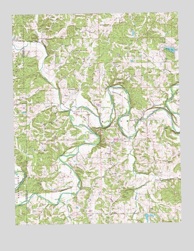
Strain, MO USGS Topographic Map
Click on map above to begin viewing in our Map Viewer.

This topographic map contains these locations and features:
Feature Name Type Latitude Longitude GNIS ID View Map
Alvina Koelling LakeReservoirN38.2600°W91.3302°764639View Map
Bartel BendBendN38.3148°W91.3252°713704View Map
Berndsen Lake DamDamN38.3500°W91.2952°764373View Map
Black Oak BranchStreamN38.3314°W91.3449°735517View Map
Boone (historical)Populated PlaceN38.2592°W91.3232°730630View Map
Boone CreekStreamN38.3006°W91.2888°731539View Map
Champion CityPopulated PlaceN38.3195°W91.2704°740735View Map
Champion City ChurchChurchN38.3112°W91.2826°715713View Map
Champion SchoolSchoolN38.3137°W91.2793°747976View Map
Clates CreekStreamN38.3192°W91.3285°715899View Map
Dutch Hill ChurchChurchN38.2864°W91.2596°717216View Map
Evergreen SchoolSchoolN38.3714°W91.3427°747972View Map
Flaker Lake DamDamN38.3467°W91.2852°763598View Map
Hecht CreekStreamN38.3037°W91.2529°719333View Map
Herman Huelhorst ReservoirReservoirN38.3467°W91.2852°763599View Map
Horse Shoe Lake DamDamN38.3634°W91.2818°764385View Map
Japan School (historical)SchoolN38.2562°W91.3143°747978View Map
Johns BranchStreamN38.3339°W91.3471°720345View Map
Kampschroeder BendBendN38.3253°W91.2932°720469View Map
Koelling Lake DamDamN38.2600°W91.3302°764638View Map
Kriete CreekStreamN38.3584°W91.3557°720698View Map
Little Boone CreekStreamN38.2784°W91.2721°721165View Map
Little Bourbeuse RiverStreamN38.2645°W91.3415°750735View Map
Lockhart CemeteryCemeteryN38.2621°W91.3552°721378View Map
Logan BranchStreamN38.2634°W91.3490°721415View Map
Long BranchStreamN38.2916°W91.2880°721505View Map
Marie Otte DamDamN38.3200°W91.2851°764640View Map
Marie Otte ReservoirReservoirN38.3200°W91.2851°764641View Map
May BranchStreamN38.3175°W91.3365°721999View Map
McCallister CemeteryCemeteryN38.3181°W91.3113°722032View Map
Melody LakeReservoirN38.3528°W91.2565°758313View Map
Melody Lake DamDamN38.3534°W91.2535°764374View Map
Miller SchoolSchoolN38.2634°W91.2743°747977View Map
Millrock FordPopulated PlaceN38.3312°W91.3035°741070View Map
New Friendship Baptist Church CemeteryCemeteryN38.3298°W91.3275°2702128View Map
New Friendship ChurchChurchN38.3303°W91.3288°723200View Map
Old Grove SchoolSchoolN38.3517°W91.2643°747975View Map
Oscar F Juergens DamDamN38.3500°W91.3218°764642View Map
Oscar F Juergons LakeReservoirN38.3500°W91.3218°764643View Map
Pentecost ChurchChurchN38.3103°W91.3490°724211View Map
Red Oak CreekStreamN38.3178°W91.3335°754139View Map
Rineck SchoolSchoolN38.2984°W91.3504°747974View Map
Rock FordPopulated PlaceN38.3231°W91.2565°741206View Map
Ruwwe School (historical)SchoolN38.2514°W91.3668°744182View Map
Schmidt CemeteryCemeteryN38.2885°W91.3025°726105View Map
School Number 16SchoolN38.2656°W91.2954°755394View Map
StrainPopulated PlaceN38.2917°W91.3029°731657View Map
Township of BooneCivilN38.3120°W91.2834°766645View Map
Triple LakesReservoirN38.3600°W91.3743°727796View Map
Trulaske Lake Section 25 DamDamN38.2584°W91.3185°764389View Map
Trulaske Lake Section 32 DamDamN38.2550°W91.2768°764380View Map
Trulaske Lake Section 33 DamDamN38.2550°W91.2735°764388View Map
W J Slais DamDamN38.3167°W91.3668°764505View Map
W J Slais LakeReservoirN38.3170°W91.3674°764506View Map
Walbert (historical)Populated PlaceN38.3300°W91.3318°755591View Map
Walbert School (historical)SchoolN38.3295°W91.3277°747973View Map
Wilson Lake DamDamN38.3000°W91.2968°765281View Map

Note: Coordinates in the location and feature list above are referenced to NAD83 datum.


Copyright (C) 2008-2024 Ryan Niemi / Sunset Dynamics ... All Rights Reserved