TopoQuest Logo
Do you find TopoQuest useful?
Help keep TopoQuest running and adding new maps/features by donating!
Bitcoin:  19c7KJd3qBynnjoSw5npx9KScwjBe4ifkT
Litecoin:  LXs6TkuXGGXo1vDsWCkWVdjQX94eUKd6ui
Home View Maps Find Maps Find Places Resources & Links


Spruce Creek, Pennsylvania Topographic Map

USGS Map Title: Spruce Creek, PA
USGS Map MRC: 40078E2
DRG (GeoTIFF) Download: o40078e2.tif


Neighboring USGS Topographic Map Quads:


  Tipton, PA  
40078F3
 

  Tyrone, PA  
40078F2
 

  Franklinville, PA  
40078F1
 

  Bellwood, PA  
40078E3
 

  Spruce Creek, PA  
40078E2
 

  Alexandria, PA  
40078E1
 

  Frankstown, PA  
40078D3
 

  Williamsburg, PA  
40078D2
 

  Huntingdon, PA  
40078D1


Map MRC Location:

N41°
W79°
N41°
W78°
H8 H7 H6 H5 H4 H3 H2 H1
G8 G7 G6 G5 G4 G3 G2 G1
F8 F7 F6 F5 F4 F3 F2 F1
E8 E7 E6 E5 E4 E3 E2 E1
D8 D7 D6 D5 D4 D3 D2 D1
C8 C7 C6 C5 C4 C3 C2 C1
B8 B7 B6 B5 B4 B3 B2 B1
A8 A7 A6 A5 A4 A3 A2 A1
N40°
W79°
N40°
W78°

Spruce Creek, PA USGS 1:24K Topographic Map Preview:
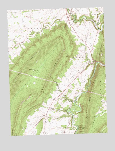
Spruce Creek, PA USGS Topographic Map
Click on map above to begin viewing in our Map Viewer.

This topographic map contains these locations and features:
Feature Name Type Latitude Longitude GNIS ID View Map
Arch SpringSpringN40.6059°W78.2045°1201477View Map
Arch SpringPopulated PlaceN40.6059°W78.2028°1168371View Map
BlairfourPopulated PlaceN40.5326°W78.1683°1203117View Map
Canoe MountainRidgeN40.5467°W78.2047°1171173View Map
Canoe ValleyFlatN40.5490°W78.1770°1171177View Map
Crossroads School (historical)SchoolN40.6176°W78.2289°1201302View Map
Eden Hill School (historical)SchoolN40.6248°W78.1528°1201301View Map
Etna FurnacePopulated PlaceN40.5234°W78.1795°1203531View Map
Fox RunStreamN40.5317°W78.1664°1175106View Map
Fox Run School (historical)SchoolN40.5345°W78.1767°1201298View Map
GoodmanLocaleN40.5498°W78.1506°1201299View Map
Keller ChapelChurchN40.5376°W78.1792°1178316View Map
Keller Church CemeteryCemeteryN40.5376°W78.1797°2776358View Map
Mount EtnaPopulated PlaceN40.5203°W78.1725°1181686View Map
Oakland School (historical)SchoolN40.6006°W78.1608°1201300View Map
PembertonPopulated PlaceN40.6220°W78.1683°1183452View Map
Roaring RunStreamN40.5228°W78.1761°1185174View Map
Saint John CemeteryCemeteryN40.5948°W78.2495°1186045View Map
ShaffersvillePopulated PlaceN40.5698°W78.1436°1187331View Map
Shaffersville CemeteryCemeteryN40.5695°W78.1442°1813190View Map
Sinking RunStreamN40.6145°W78.1611°1193368View Map
Sinking ValleyValleyN40.6157°W78.1639°1187721View Map
Sinking Valley CemeteryCemeteryN40.6101°W78.1978°2776385View Map
Sinking Valley ChurchChurchN40.6103°W78.1967°1187722View Map
Spruce CreekPopulated PlaceN40.6095°W78.1356°1188325View Map
Spruce CreekStreamN40.6087°W78.1358°1188326View Map
Spruce Creek Post OfficePost OfficeN40.6102°W78.1343°2779812View Map
State Game Lands Number 166ParkN40.5651°W78.2122°1188465View Map
Township of CatharineCivilN40.5242°W78.2048°1215959View Map
Township of MorrisCivilN40.5733°W78.1622°1216515View Map
Township of Spruce CreekCivilN40.6198°W78.1371°1216523View Map
Union FurnacePopulated PlaceN40.6128°W78.1631°1190154View Map
Water StreetPopulated PlaceN40.5715°W78.1381°1200128View Map
Waterstreet CemeteryCemeteryN40.5712°W78.1403°1958424View Map
Williams CemeteryCemeteryN40.5595°W78.2233°1191456View Map
Yellow SpringPopulated PlaceN40.5173°W78.2067°1205004View Map
Yellow Spring RunStreamN40.5220°W78.1742°1191883View Map
Yellow Springs Henrys Lutheran CemeteryCemeteryN40.5216°W78.2019°2776395View Map

Note: Coordinates in the location and feature list above are referenced to NAD83 datum.


Copyright (C) 2008-2024 Ryan Niemi / Sunset Dynamics ... All Rights Reserved