TopoQuest Logo
Do you find TopoQuest useful?
Help keep TopoQuest running and adding new maps/features by donating!
Bitcoin:  19c7KJd3qBynnjoSw5npx9KScwjBe4ifkT
Litecoin:  LXs6TkuXGGXo1vDsWCkWVdjQX94eUKd6ui
Home View Maps Find Maps Find Places Resources & Links


Ridgecrest South, California Topographic Map

USGS Map Title: Ridgecrest South, CA
USGS Map MRC: 35117E6
DRG (GeoTIFF) Download: o35117e6.tif


Neighboring USGS Topographic Map Quads:


  Inyokern, CA  
35117F7
 

  Ridgecrest North, CA  
35117F6
 

  Lone Butte, CA  
35117F5
 

  Inyokern SE, CA  
35117E7
 

  Ridgecrest South, CA  
35117E6
 

  Spangler Hills West, CA  
35117E5
 

  Garlock, CA  
35117D7
 

  El Paso Peaks, CA  
35117D6
 

  Klinker Mountain, CA  
35117D5


Map MRC Location:

N36°
W118°
N36°
W117°
H8 H7 H6 H5 H4 H3 H2 H1
G8 G7 G6 G5 G4 G3 G2 G1
F8 F7 F6 F5 F4 F3 F2 F1
E8 E7 E6 E5 E4 E3 E2 E1
D8 D7 D6 D5 D4 D3 D2 D1
C8 C7 C6 C5 C4 C3 C2 C1
B8 B7 B6 B5 B4 B3 B2 B1
A8 A7 A6 A5 A4 A3 A2 A1
N35°
W118°
N35°
W117°

Ridgecrest South, CA USGS 1:24K Topographic Map Preview:
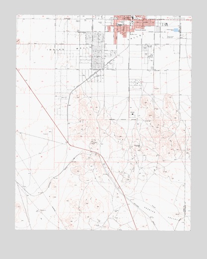
Ridgecrest South, CA USGS Topographic Map
Click on map above to begin viewing in our Map Viewer.

This topographic map contains these locations and features:
Feature Name Type Latitude Longitude GNIS ID View Map
Calvary Assembly of God ChurchChurchN35.6155°W117.6862°1836039View Map
Cerro Coso Community CollegeSchoolN35.5675°W117.6676°240450View Map
Davis Airport (historical)AirportN35.6102°W117.6726°1670218View Map
Desert Empire FairgroundsLocaleN35.6127°W117.6456°241432View Map
Desert Memorial ParkParkN35.6119°W117.6353°241438View Map
Faller Elementary SchoolSchoolN35.6146°W117.7021°248181View Map
First Baptist Church of RidgecrestChurchN35.5997°W117.6878°1835861View Map
First Landmark Missionary Baptist ChurchChurchN35.6227°W117.6787°1836044View Map
Foursquare Gospel ChurchChurchN35.6188°W117.6792°1836047View Map
Gateway Elementary SchoolSchoolN35.6144°W117.6531°1835866View Map
Goldbug MineMineN35.5491°W117.6634°242812View Map
Hellmers ParkParkN35.6211°W117.6770°243348View Map
James Monroe Middle SchoolSchoolN35.6193°W117.6763°246092View Map
Kern County Fire Department Station 77 Ridgecrest HeightsBuildingN35.6004°W117.6863°1835858View Map
Kingdom Hall of Jehovahs WitnessesChurchN35.6186°W117.6578°1835884View Map
KLOA-AM (Ridgecrest)TowerN35.6233°W117.6870°1664917View Map
KLOA-FM (Ridgecrest)TowerN35.6233°W117.6870°1665073View Map
KZIQ-AM (Ridgecrest)TowerN35.6161°W117.6440°1664918View Map
Liberty Ambulance ServiceBuildingN35.6223°W117.6975°2665487View Map
Lonely Camp MineMineN35.5602°W117.6534°1670227View Map
New Beginnings Baptist Fellowship ChurchChurchN35.6244°W117.6748°1835893View Map
Rademacher Mining DistrictAreaN35.5463°W117.6709°1670230View Map
RidgecrestPopulated PlaceN35.6225°W117.6709°1652783View Map
Ridgecrest City HallBuildingN35.6238°W117.6715°1835902View Map
Ridgecrest Plaza Shopping CenterLocaleN35.6236°W117.6681°1835903View Map
Ridgecrest Police DepartmentBuildingN35.6211°W117.6724°2756389View Map
Saint Ann Catholic SchoolSchoolN35.6196°W117.6779°248534View Map
Saint Anns Catholic ChurchChurchN35.6191°W117.6778°1836058View Map
SCE Ridgecrest Service Center HeliportAirportN35.6144°W117.6686°1653879View Map
Shekinah Christian Fellowship ChurchChurchN35.6241°W117.6726°1836065View Map
Stauffer ParkParkN35.6205°W117.6901°249891View Map
Tera Ultralight FlightparkAirportN35.5913°W117.6267°2650930View Map
True Love Baptist ChurchChurchN35.6150°W117.6831°1836066View Map
United Church of Religious ScienceChurchN35.6233°W117.6726°1836067View Map
Unity ChurchChurchN35.6233°W117.6726°1836068View Map
Upjohn ParkParkN35.6147°W117.6592°1835924View Map
Victory Baptist ChurchChurchN35.6244°W117.6742°1835926View Map

Note: Coordinates in the location and feature list above are referenced to NAD83 datum.


Copyright (C) 2008-2024 Ryan Niemi / Sunset Dynamics ... All Rights Reserved