TopoQuest Logo
Do you find TopoQuest useful?
Help keep TopoQuest running and adding new maps/features by donating!
Bitcoin:  19c7KJd3qBynnjoSw5npx9KScwjBe4ifkT
Litecoin:  LXs6TkuXGGXo1vDsWCkWVdjQX94eUKd6ui
Home View Maps Find Maps Find Places Resources & Links


Garlock, California Topographic Map

USGS Map Title: Garlock, CA
USGS Map MRC: 35117D7
DRG (GeoTIFF) Download: o35117d7.tif


Neighboring USGS Topographic Map Quads:


  Freeman Junction, CA  
35117E8
 

  Inyokern SE, CA  
35117E7
 

  Ridgecrest South, CA  
35117E6
 

  Saltdale NW, CA  
35117D8
 

  Garlock, CA  
35117D7
 

  El Paso Peaks, CA  
35117D6
 

  Cantil, CA  
35117C8
 

  Saltdale SE, CA  
35117C7
 

  Johannesburg, CA  
35117C6


Map MRC Location:

N36°
W118°
N36°
W117°
H8 H7 H6 H5 H4 H3 H2 H1
G8 G7 G6 G5 G4 G3 G2 G1
F8 F7 F6 F5 F4 F3 F2 F1
E8 E7 E6 E5 E4 E3 E2 E1
D8 D7 D6 D5 D4 D3 D2 D1
C8 C7 C6 C5 C4 C3 C2 C1
B8 B7 B6 B5 B4 B3 B2 B1
A8 A7 A6 A5 A4 A3 A2 A1
N35°
W118°
N35°
W117°

Garlock, CA USGS 1:24K Topographic Map Preview:
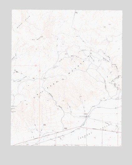
Garlock, CA USGS Topographic Map
Click on map above to begin viewing in our Map Viewer.

This topographic map contains these locations and features:
Feature Name Type Latitude Longitude GNIS ID View Map
Apache MineMineN35.4580°W117.8078°238663View Map
Benson GulchValleyN35.4255°W117.7531°239228View Map
Black HillsRangeN35.4883°W117.8645°239406View Map
Black MountainSummitN35.4752°W117.8423°239429View Map
Colorado CampLocaleN35.4480°W117.8276°240800View Map
El Paso MountainsRangeN35.4377°W117.8159°241907View Map
GarlockPopulated PlaceN35.4025°W117.7901°1656526View Map
Garlock Historical MarkerParkN35.4022°W117.7903°1654644View Map
Garlock Station (historical)LocaleN35.3925°W117.7973°1702129View Map
Gerbracht CampLocaleN35.4372°W117.8390°242681View Map
Goler GulchValleyN35.4261°W117.7509°242836View Map
Holland CampLocaleN35.4627°W117.7953°243537View Map
Iron CanyonValleyN35.4211°W117.7640°243883View Map
Mesa SpringSpringN35.4425°W117.8706°245808View Map
Mesquite CanyonValleyN35.3936°W117.8170°245813View Map
Mesquite SpringsSpringN35.3902°W117.8140°245830View Map
Mormon FlatFlatN35.4552°W117.7853°246202View Map
Mormon GulchValleyN35.4511°W117.7631°246204View Map
Old GarlockPopulated PlaceN35.3758°W117.8251°1702132View Map
Owens CampLocaleN35.4433°W117.8703°247045View Map
Poison SpringSpringN35.3941°W117.8390°247660View Map
Prospect MineMineN35.4300°W117.8565°1702133View Map
Sand GulchValleyN35.4383°W117.7537°248998View Map
Schmidt CampLocaleN35.4111°W117.8742°249199View Map
Sheep SpringSpringN35.4975°W117.8042°249377View Map
Smith MineMineN35.4369°W117.8512°249590View Map
The NarrowsGapN35.4500°W117.7626°250390View Map

Note: Coordinates in the location and feature list above are referenced to NAD83 datum.


Copyright (C) 2008-2024 Ryan Niemi / Sunset Dynamics ... All Rights Reserved