TopoQuest Logo
Do you find TopoQuest useful?
Help keep TopoQuest running and adding new maps/features by donating!
Bitcoin:  19c7KJd3qBynnjoSw5npx9KScwjBe4ifkT
Litecoin:  LXs6TkuXGGXo1vDsWCkWVdjQX94eUKd6ui
Home View Maps Find Maps Find Places Resources & Links


Big Cormorant Lake, Minnesota Topographic Map

USGS Map Title: Big Cormorant Lake, MN
USGS Map MRC: 46096G1
DRG (GeoTIFF) Download: o46096g1.tif


Neighboring USGS Topographic Map Quads:


  Dale, MN  
46096H2
 

  Lake Park, MN  
46096H1
 

  Callaway, MN  
46095H8
 

  Lake Park SW, MN  
46096G2
 

  Big Cormorant Lake, MN  
46096G1
 

  Audubon, MN  
46095G8
 

  Rollag, MN  
46096F2
 

  Cormorant, MN  
46096F1
 

  Lake Franklin, MN  
46095F8


Map MRC Location:

N47°
W97°
N47°
W96°
H8 H7 H6 H5 H4 H3 H2 H1
G8 G7 G6 G5 G4 G3 G2 G1
F8 F7 F6 F5 F4 F3 F2 F1
E8 E7 E6 E5 E4 E3 E2 E1
D8 D7 D6 D5 D4 D3 D2 D1
C8 C7 C6 C5 C4 C3 C2 C1
B8 B7 B6 B5 B4 B3 B2 B1
A8 A7 A6 A5 A4 A3 A2 A1
N46°
W97°
N46°
W96°

Big Cormorant Lake, MN USGS 1:24K Topographic Map Preview:
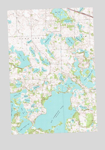
Big Cormorant Lake, MN USGS Topographic Map
Click on map above to begin viewing in our Map Viewer.

This topographic map contains these locations and features:
Feature Name Type Latitude Longitude GNIS ID View Map
Arrow LakeLakeN46.7609°W96.0365°639452View Map
Audubon CemeteryCemeteryN46.8630°W96.0075°639505View Map
Barnes LakeLakeN46.8562°W96.0207°639634View Map
Big Cormorant LakeLakeN46.7672°W96.0582°640083View Map
Boyer LakeLakeN46.8705°W96.0496°640407View Map
Camp CormorantLocaleN46.7833°W96.0728°640794View Map
Dahlberg LakeLakeN46.8058°W96.0502°642589View Map
Eilertson LakeLakeN46.7746°W96.0225°643217View Map
Engebretson LakeLakeN46.8232°W96.0738°643378View Map
Erickson LakeLakeN46.7894°W96.1158°643399View Map
Felker CemeteryCemeteryN46.8489°W96.0069°2108270View Map
Felker Family CemeteryCemeteryN46.8476°W96.0022°1829036View Map
Felker LakeLakeN46.8616°W96.0378°643593View Map
Forget-me-not LakeLakeN46.8438°W96.0690°643818View Map
Frisk LakeLakeN46.8137°W96.0861°643966View Map
Gilbertson LakeLakeN46.8737°W96.0174°644131View Map
Horan LakeLakeN46.8326°W96.0909°645189View Map
Hougland LakeLakeN46.7963°W96.0878°645249View Map
Kaiser's AirstripAirportN46.7968°W96.1006°2676855View Map
Larson LakeLakeN46.7837°W96.1009°646506View Map
Larson LakeLakeN46.8298°W96.0148°646507View Map
Leaf LakeLakeN46.7964°W96.0407°646558View Map
Little Cormorant LakeLakeN46.8075°W96.0131°646786View Map
Marshall LakeReservoirN46.8350°W96.0303°1776136View Map
Marshall LakeLakeN46.8411°W96.0356°647567View Map
Marshall Lake DamDamN46.8350°W96.0303°1776135View Map
Middle Cormorant LakeLakeN46.7638°W96.1072°647803View Map
Mollar LakeLakeN46.7879°W96.1029°648017View Map
Nelson LakeLakeN46.7730°W96.1081°648462View Map
Nelson LakeLakeN46.8004°W96.1128°648463View Map
North Shore Trailer ParkPopulated PlaceN46.7900°W96.0556°2108413View Map
Orange LakeLakeN46.8313°W96.0655°648985View Map
Roberg LakeLakeN46.8425°W96.0949°650167View Map
Rose Haven CampgroundLocaleN46.7833°W96.0728°2108412View Map
South Barnes LakeLakeN46.8444°W96.0218°652268View Map
Stakke LakeLakeN46.8252°W96.1055°652536View Map
Strandvik CemeteryCemeteryN46.8202°W96.0659°2108267View Map
Strandvik ChurchChurchN46.8200°W96.0653°652717View Map
Swanies CampgroundLocaleN46.7569°W96.0972°2108411View Map
Township of CormorantCivilN46.7614°W96.1121°663873View Map
Township of Lake ParkCivilN46.8470°W96.1126°664694View Map
West LakeLakeN46.8139°W96.0753°653977View Map

Note: Coordinates in the location and feature list above are referenced to NAD83 datum.


Copyright (C) 2008-2024 Ryan Niemi / Sunset Dynamics ... All Rights Reserved