TopoQuest Logo
Do you find TopoQuest useful?
Help keep TopoQuest running and adding new maps/features by donating!
Bitcoin:  19c7KJd3qBynnjoSw5npx9KScwjBe4ifkT
Litecoin:  LXs6TkuXGGXo1vDsWCkWVdjQX94eUKd6ui
Home View Maps Find Maps Find Places Resources & Links


Lake Franklin, Minnesota Topographic Map

USGS Map Title: Lake Franklin, MN
USGS Map MRC: 46095F8
DRG (GeoTIFF) Download: o46095f8.tif


Neighboring USGS Topographic Map Quads:


  Big Cormorant Lake, MN  
46096G1
 

  Audubon, MN  
46095G8
 

  Detroit Lakes, MN  
46095G7
 

  Cormorant, MN  
46096F1
 

  Lake Franklin, MN  
46095F8
 

  Vergas, MN  
46095F7
 

  Pelican Rapids, MN  
46096E1
 

  Lake Lida, MN  
46095E8
 

  Star Lake, MN  
46095E7


Map MRC Location:

N47°
W96°
N47°
W95°
H8 H7 H6 H5 H4 H3 H2 H1
G8 G7 G6 G5 G4 G3 G2 G1
F8 F7 F6 F5 F4 F3 F2 F1
E8 E7 E6 E5 E4 E3 E2 E1
D8 D7 D6 D5 D4 D3 D2 D1
C8 C7 C6 C5 C4 C3 C2 C1
B8 B7 B6 B5 B4 B3 B2 B1
A8 A7 A6 A5 A4 A3 A2 A1
N46°
W96°
N46°
W95°

Lake Franklin, MN USGS 1:24K Topographic Map Preview:
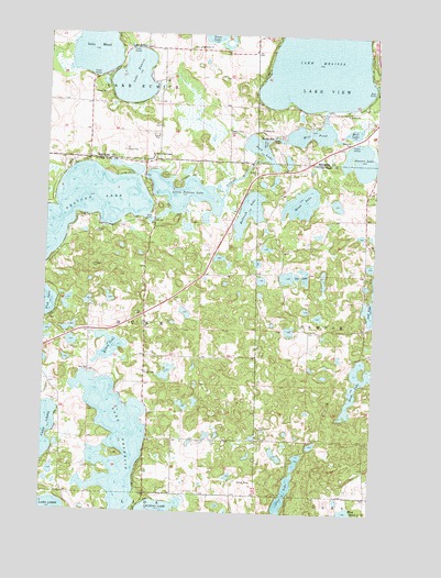
Lake Franklin, MN USGS Topographic Map
Click on map above to begin viewing in our Map Viewer.

This topographic map contains these locations and features:
Feature Name Type Latitude Longitude GNIS ID View Map
Augustana ChurchChurchN46.7463°W95.9442°639523View Map
Augustana Lutheran CemeteryCemeteryN46.7465°W95.9447°2108244View Map
Buck LakeLakeN46.7202°W95.9199°640583View Map
Bucks MillPopulated PlaceN46.7230°W95.9151°654619View Map
Bucks Mills Post Office (historical)Post OfficeN46.7231°W95.9147°2108610View Map
Elbow LakeLakeN46.6681°W95.9752°643226View Map
Eunice LakeReservoirN46.7366°W95.9420°1776110View Map
Eunice Lake DamDamN46.7366°W95.9420°1776109View Map
Hand LakeLakeN46.7064°W95.9033°644620View Map
Holbrook LakeLakeN46.7040°W95.9234°645068View Map
Hook LakeLakeN46.6593°W95.8806°645156View Map
Lake EunicePopulated PlaceN46.7461°W95.9692°654699View Map
Lake EuniceLakeN46.7384°W95.9682°643427View Map
Lake Eunice CemeteryCemeteryN46.7248°W95.9313°646347View Map
Lake Eunice Post Office (historical)Post OfficeN46.7461°W95.9689°2108600View Map
Lake FranklinLakeN46.6433°W95.9725°643894View Map
Lake MaudLakeN46.7472°W95.9836°647622View Map
Lake MelissaReservoirN46.7425°W95.8972°1776114View Map
Little Pelican LakeLakeN46.7082°W95.9484°646880View Map
Meadow Lake CampsiteLocaleN46.7494°W95.8767°2108293View Map
Mill LakeLakeN46.7249°W95.8842°647852View Map
Mill PondLakeN46.7242°W95.9011°647856View Map
Minnow PondLakeN46.7218°W95.9179°647971View Map
Otter LakeLakeN46.6299°W95.9079°649057View Map
Saint Mary of the Lakes CemeteryCemeteryN46.7179°W95.9605°2108245View Map
Saint Mary of the Lakes ChurchChurchN46.7175°W95.9606°650827View Map
Sauers LakeLakeN46.7175°W95.8818°651232View Map
Sauers Lake Rest AreaLocaleN46.7225°W95.8844°2108746View Map
Tee LakeLakeN46.6869°W95.9061°653066View Map
Township of DunnCivilN46.6734°W95.9836°664011View Map
Wildflower at Fair Hills Golf CourseLocaleN46.7181°W95.9847°2108751View Map
Windflower Golf CourseLocaleN46.7181°W95.9847°2108714View Map
Zion CemeteryCemeteryN46.6617°W95.9828°2072705View Map
Zion ChurchChurchN46.6619°W95.9834°654484View Map

Note: Coordinates in the location and feature list above are referenced to NAD83 datum.


Copyright (C) 2008-2024 Ryan Niemi / Sunset Dynamics ... All Rights Reserved