TopoQuest Logo
Do you find TopoQuest useful?
Help keep TopoQuest running and adding new maps/features by donating!
Bitcoin:  19c7KJd3qBynnjoSw5npx9KScwjBe4ifkT
Litecoin:  LXs6TkuXGGXo1vDsWCkWVdjQX94eUKd6ui
Home View Maps Find Maps Find Places Resources & Links


Phelps, Texas Topographic Map

USGS Map Title: Phelps, TX
USGS Map MRC: 30095F4
DRG (GeoTIFF) Download: o30095f4.tif


Neighboring USGS Topographic Map Quads:


  Pine Prairie, TX  
30095G5
 

  Riverside, TX  
30095G4
 

  Staley, TX  
30095G3
 

  Huntsville, TX  
30095F5
 

  Phelps, TX  
30095F4
 

  Oakhurst, TX  
30095F3
 

  Moore Grove, TX  
30095E5
 

  New Waverly, TX  
30095E4
 

  Maynard, TX  
30095E3


Map MRC Location:

N31°
W96°
N31°
W95°
H8 H7 H6 H5 H4 H3 H2 H1
G8 G7 G6 G5 G4 G3 G2 G1
F8 F7 F6 F5 F4 F3 F2 F1
E8 E7 E6 E5 E4 E3 E2 E1
D8 D7 D6 D5 D4 D3 D2 D1
C8 C7 C6 C5 C4 C3 C2 C1
B8 B7 B6 B5 B4 B3 B2 B1
A8 A7 A6 A5 A4 A3 A2 A1
N30°
W96°
N30°
W95°

Phelps, TX USGS 1:24K Topographic Map Preview:
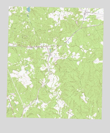
Phelps, TX USGS Topographic Map
Click on map above to begin viewing in our Map Viewer.

This topographic map contains these locations and features:
Feature Name Type Latitude Longitude GNIS ID View Map
Blackjack CemeteryCemeteryN30.6471°W95.4594°1381452View Map
Burt CreekStreamN30.7466°W95.4299°1381558View Map
Cabin CreekStreamN30.6546°W95.4449°1381564View Map
Campground ChurchChurchN30.7046°W95.4669°1381575View Map
Caney CreekStreamN30.6460°W95.4347°1381584View Map
DodgePopulated PlaceN30.7455°W95.3980°1381774View Map
Dodge LookoutLocaleN30.7460°W95.3902°1381775View Map
Dodge Post OfficePost OfficeN30.7426°W95.3998°2732177View Map
Dodge Volunteer Fire DepartmentBuildingN30.7449°W95.3971°2655690View Map
East Fork Harmon CreekStreamN30.7263°W95.4658°1381814View Map
Elder CreekStreamN30.7499°W95.4127°1383090View Map
Everlena ChurchChurchN30.7449°W95.4411°1381854View Map
Ford BranchStreamN30.7324°W95.4813°1381882View Map
Four Notch LookoutLocaleN30.6455°W95.4236°1381890View Map
Grant Colony CemeteryCemeteryN30.7219°W95.4936°1381935View Map
Green Loop TrailTrailN30.6549°W95.4211°2033536View Map
HarmonyPopulated PlaceN30.7330°W95.4769°1381967View Map
Hatchery LakeReservoirN30.7402°W95.4752°1860068View Map
Hatchery Lake DamDamN30.7402°W95.4752°1860067View Map
Joy LakeLakeN30.6760°W95.4438°1382097View Map
Lone Star TrailTrailN30.6491°W95.4183°1385473View Map
Maria LakeReservoirN30.7397°W95.4290°1864294View Map
Maria Lake DamDamN30.7402°W95.4286°1864293View Map
Mays CreekStreamN30.6638°W95.4522°1382246View Map
McMillian LakeReservoirN30.7336°W95.4106°1864296View Map
McMillian Lake DamDamN30.7352°W95.4119°1864295View Map
Mitcham LakeReservoirN30.6517°W95.4929°1864292View Map
Mitcham Lake DamDamN30.6519°W95.4902°1864291View Map
Morian-Sam Houston Oil FieldOilfieldN30.7130°W95.4766°1382323View Map
Mount MorianPopulated PlaceN30.7263°W95.4916°1382340View Map
New Zion ChurchChurchN30.7052°W95.4544°1382392View Map
PhelpsPopulated PlaceN30.6963°W95.4444°1382490View Map
Phelps CreekStreamN30.6638°W95.4522°1382491View Map
Pine ValleyPopulated PlaceN30.6605°W95.4524°1382515View Map
Robins CreekStreamN30.7469°W95.4316°1382626View Map
Shepherd CreekStreamN30.6638°W95.4522°1382754View Map
Shiloh ChurchChurchN30.7046°W95.4611°1382756View Map
Thickett BranchStreamN30.6566°W95.4027°1382855View Map
Tillie LakeReservoirN30.7011°W95.4442°1382867View Map
Tillie Lake DamDamN30.7019°W95.4436°1860069View Map
Watson East DamDamN30.6902°W95.4369°1860073View Map
Watson East LakeReservoirN30.6919°W95.4358°1860074View Map
Watson South DamDamN30.6869°W95.4369°1862586View Map
Watson South LakeReservoirN30.6870°W95.4368°1862587View Map
Watson West DamDamN30.6902°W95.4386°1860071View Map
Watson West LakeReservoirN30.6912°W95.4382°1860072View Map
Wayne CreekStreamN30.7402°W95.4749°1382926View Map

Note: Coordinates in the location and feature list above are referenced to NAD83 datum.


Copyright (C) 2008-2024 Ryan Niemi / Sunset Dynamics ... All Rights Reserved