TopoQuest Logo
Do you find TopoQuest useful?
Help keep TopoQuest running and adding new maps/features by donating!
Bitcoin:  19c7KJd3qBynnjoSw5npx9KScwjBe4ifkT
Litecoin:  LXs6TkuXGGXo1vDsWCkWVdjQX94eUKd6ui
Home View Maps Find Maps Find Places Resources & Links


Maynard, Texas Topographic Map

USGS Map Title: Maynard, TX
USGS Map MRC: 30095E3
DRG (GeoTIFF) Download: o30095e3.tif


Neighboring USGS Topographic Map Quads:


  Phelps, TX  
30095F4
 

  Oakhurst, TX  
30095F3
 

  Stephen Creek, TX  
30095F2
 

  New Waverly, TX  
30095E4
 

  Maynard, TX  
30095E3
 

  Coldspring, TX  
30095E2
 

  Willis, TX  
30095D4
 

  Conroe NE, TX  
30095D3
 

  Bear Creek, TX  
30095D2


Map MRC Location:

N31°
W96°
N31°
W95°
H8 H7 H6 H5 H4 H3 H2 H1
G8 G7 G6 G5 G4 G3 G2 G1
F8 F7 F6 F5 F4 F3 F2 F1
E8 E7 E6 E5 E4 E3 E2 E1
D8 D7 D6 D5 D4 D3 D2 D1
C8 C7 C6 C5 C4 C3 C2 C1
B8 B7 B6 B5 B4 B3 B2 B1
A8 A7 A6 A5 A4 A3 A2 A1
N30°
W96°
N30°
W95°

Maynard, TX USGS 1:24K Topographic Map Preview:
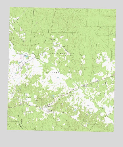
Maynard, TX USGS Topographic Map
Click on map above to begin viewing in our Map Viewer.

This topographic map contains these locations and features:
Feature Name Type Latitude Longitude GNIS ID View Map
A and W Ranch LakeReservoirN30.5219°W95.2962°1864507View Map
A and W Ranch Lake DamDamN30.5219°W95.2952°1864506View Map
Big Woods Hunter CampLocaleN30.6146°W95.2919°1383483View Map
Black BranchStreamN30.5258°W95.2644°1381442View Map
Boswell CreekStreamN30.5777°W95.3499°1381489View Map
Brandy CreekStreamN30.5999°W95.3644°1381504View Map
Brickyard BranchStreamN30.5027°W95.3016°1381514View Map
Caney CreekStreamN30.5616°W95.3152°1381578View Map
Chinquapin CreekStreamN30.5458°W95.2919°1381634View Map
East Fork Caney CreekStreamN30.5858°W95.3074°1381813View Map
East Fork Pumpkin CreekStreamN30.5691°W95.2736°1381816View Map
Hargrove CemeteryCemeteryN30.5308°W95.3419°1381966View Map
Hopkins BranchStreamN30.5705°W95.3358°1382027View Map
Lewis CemeteryCemeteryN30.5396°W95.3024°1382143View Map
MaynardPopulated PlaceN30.5221°W95.3280°1382245View Map
Mount Pilgrim ChurchChurchN30.5205°W95.3252°1382344View Map
New Hope ChurchChurchN30.5860°W95.3116°1382384View Map
Old WaverlyPopulated PlaceN30.5291°W95.3527°1382433View Map
Old Waverly CemeteryCemeteryN30.5335°W95.3641°1382434View Map
Old Waverly ChurchChurchN30.5335°W95.3513°1382435View Map
Pea CreekStreamN30.5810°W95.3524°1382467View Map
Pine Grove Missionary ChurchChurchN30.5244°W95.3277°1382506View Map
Pine Valley ChurchChurchN30.5930°W95.3241°1382517View Map
Pleasant Grove ChurchChurchN30.5471°W95.2858°1382529View Map
Pleasant Grove Missionary ChurchChurchN30.5458°W95.2824°1365420View Map
PumpkinPopulated PlaceN30.5474°W95.2841°2034868View Map
Pumpkin CreekStreamN30.5355°W95.2783°1382582View Map
Punkin - Evergreen Volunteer Fire DepartmentBuildingN30.5478°W95.2841°2655387View Map
Pursley LakeLakeN30.5753°W95.3543°1382584View Map
Rocky CreekStreamN30.5394°W95.3005°1382641View Map
Sam Houston National ForestForestN30.5413°W95.3505°1383229View Map
Scott CemeteryCemeteryN30.5260°W95.3291°1382728View Map
WaverlyPopulated PlaceN30.5249°W95.3505°2034761View Map
West Fork Caney CreekStreamN30.5860°W95.3074°1382932View Map
West Fork Pumpkin CreekStreamN30.5691°W95.2736°1382934View Map
Williams CemeteryCemeteryN30.5191°W95.3263°1382967View Map

Note: Coordinates in the location and feature list above are referenced to NAD83 datum.


Copyright (C) 2008-2024 Ryan Niemi / Sunset Dynamics ... All Rights Reserved