TopoQuest Logo
Do you find TopoQuest useful?
Help keep TopoQuest running and adding new maps/features by donating!
Bitcoin:  19c7KJd3qBynnjoSw5npx9KScwjBe4ifkT
Litecoin:  LXs6TkuXGGXo1vDsWCkWVdjQX94eUKd6ui
Home View Maps Find Maps Find Places Resources & Links


Pelican, Louisiana Topographic Map

USGS Map Title: Pelican, LA
USGS Map MRC: 31093H5
DRG (GeoTIFF) Download: o31093h5.tif


Neighboring USGS Topographic Map Quads:


  Mansfield, LA  
32093A6
 

  Bayou Pierre Lake, LA  
32093A5
 

  Harmon, LA  
32093A4
 

  Trenton, LA  
31093H6
 

  Pelican, LA  
31093H5
 

  Evelyn, LA  
31093H4
 

  Converse, LA  
31093G6
 

  Pleasant Hill, LA  
31093G5
 

  Hollis Creek, LA  
31093G4


Map MRC Location:

N32°
W94°
N32°
W93°
H8 H7 H6 H5 H4 H3 H2 H1
G8 G7 G6 G5 G4 G3 G2 G1
F8 F7 F6 F5 F4 F3 F2 F1
E8 E7 E6 E5 E4 E3 E2 E1
D8 D7 D6 D5 D4 D3 D2 D1
C8 C7 C6 C5 C4 C3 C2 C1
B8 B7 B6 B5 B4 B3 B2 B1
A8 A7 A6 A5 A4 A3 A2 A1
N31°
W94°
N31°
W93°

Pelican, LA USGS 1:24K Topographic Map Preview:
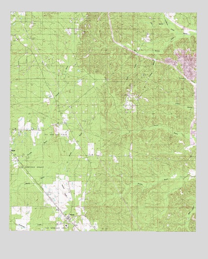
Pelican, LA USGS Topographic Map
Click on map above to begin viewing in our Map Viewer.

This topographic map contains these locations and features:
Feature Name Type Latitude Longitude GNIS ID View Map
All Saints-Pelican Elementary SchoolSchoolN31.8877°W93.5918°1629749View Map
Cave BranchStreamN31.9791°W93.5218°533830View Map
DeSoto Lookout TowerTowerN31.9668°W93.5696°558760View Map
Dolette (historical)Populated PlaceN31.9735°W93.5460°545612View Map
Dolette HillsRangeN31.9557°W93.5127°545613View Map
Dry BayouStreamN31.9893°W93.5152°534592View Map
East Trenton Oil FieldOilfieldN31.9299°W93.5946°545616View Map
Fraigeson CreekStreamN31.9879°W93.5135°535078View Map
Grove HillPopulated PlaceN31.9618°W93.5605°545628View Map
Grove Hill ChurchChurchN31.9618°W93.5610°535432View Map
Mount Zion ChurchChurchN31.9885°W93.5335°537442View Map
Mustard CreekStreamN31.9052°W93.5918°537506View Map
Oxford Gas FieldOilfieldN31.8904°W93.5974°545654View Map
Parish Governing Authority District 6CivilN31.9120°W93.5387°1930129View Map
PelicanPopulated PlaceN31.8824°W93.5860°538048View Map
Pelican All Saints High SchoolSchoolN31.8784°W93.5871°545656View Map
Pelican Post OfficePost OfficeN31.8818°W93.5860°1630270View Map
Rambin SchoolSchoolN31.9163°W93.5085°538488View Map
Rocky BayouStreamN31.9763°W93.5391°538668View Map
Saint Matthews ChurchChurchN31.9166°W93.5260°539004View Map
Saint Pauls ChurchChurchN31.9071°W93.5680°555934View Map
Ten Mile Bayou Oil and Gas FieldOilfieldN31.9724°W93.5918°545667View Map
Ward SevenCivilN31.9157°W93.5268°545001View Map

Note: Coordinates in the location and feature list above are referenced to NAD83 datum.


Copyright (C) 2008-2024 Ryan Niemi / Sunset Dynamics ... All Rights Reserved