TopoQuest Logo
Do you find TopoQuest useful?
Help keep TopoQuest running and adding new maps/features by donating!
Bitcoin:  19c7KJd3qBynnjoSw5npx9KScwjBe4ifkT
Litecoin:  LXs6TkuXGGXo1vDsWCkWVdjQX94eUKd6ui
Home View Maps Find Maps Find Places Resources & Links


Mercersburg, Pennsylvania Topographic Map

USGS Map Title: Mercersburg, PA
USGS Map MRC: 39077G8
DRG (GeoTIFF) Download: o39077g8.tif


Neighboring USGS Topographic Map Quads:


  Meadow Grounds, PA  
39078H1
 

  McConnellsburg, PA  
39077H8
 

  Saint Thomas, PA  
39077H7
 

  Big Cove Tannery, PA  
39078G1
 

  Mercersburg, PA  
39077G8
 

  Williamson, PA  
39077G7
 

  Cherry Run, WV  
39078F1
 

  Clear Spring, MD  
39077F8
 

  Mason and Dixon, PA  
39077F7


Map MRC Location:

N40°
W78°
N40°
W77°
H8 H7 H6 H5 H4 H3 H2 H1
G8 G7 G6 G5 G4 G3 G2 G1
F8 F7 F6 F5 F4 F3 F2 F1
E8 E7 E6 E5 E4 E3 E2 E1
D8 D7 D6 D5 D4 D3 D2 D1
C8 C7 C6 C5 C4 C3 C2 C1
B8 B7 B6 B5 B4 B3 B2 B1
A8 A7 A6 A5 A4 A3 A2 A1
N39°
W78°
N39°
W77°

Mercersburg, PA USGS 1:24K Topographic Map Preview:
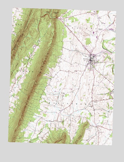
Mercersburg, PA USGS Topographic Map
Click on map above to begin viewing in our Map Viewer.

This topographic map contains these locations and features:
Feature Name Type Latitude Longitude GNIS ID View Map
Blair ValleyValleyN39.7787°W77.9135°583284View Map
Blue SpringLocaleN39.7959°W77.9356°1212857View Map
Blue Spring CreekStreamN39.7815°W77.9394°1198038View Map
Blue Spring SchoolSchoolN39.7962°W77.9356°1169900View Map
Borough of MercersburgCivilN39.8319°W77.9029°1215245View Map
Buchanan SchoolSchoolN39.8637°W77.9389°1170501View Map
Buchanan's Birthplace State ParkParkN39.8708°W77.9540°2351403View Map
Buchanans BirthplaceLocaleN39.8701°W77.9531°1212858View Map
Buck RunStreamN39.8601°W77.8861°1170546View Map
Buck Run DamDamN39.8684°W77.9531°1194393View Map
CharlestownPopulated PlaceN39.8601°W77.9344°1171582View Map
ClaylickPopulated PlaceN39.7668°W77.8936°1171950View Map
Claylick MountainSummitN39.7568°W77.9133°1192272View Map
Claylick SchoolSchoolN39.7612°W77.8911°1171952View Map
Cove GapPopulated PlaceN39.8659°W77.9425°1172524View Map
Cove MountainRidgeN39.8026°W77.9719°1172526View Map
DickeyPopulated PlaceN39.8681°W77.8956°1203414View Map
James Buchanan Middle SchoolSchoolN39.8501°W77.8889°1207235View Map
James Buchanan Senior High SchoolSchoolN39.8543°W77.9014°1207236View Map
Johnston RunStreamN39.8226°W77.8761°1178129View Map
Lafayette SchoolSchoolN39.7709°W77.9336°1178753View Map
Lenwood HeightsPopulated PlaceN39.8320°W77.8881°1212856View Map
Little Cove ValleyValleyN39.7934°W77.9958°1179514View Map
MercersburgPopulated PlaceN39.8279°W77.9033°1180935View Map
Mercersburg - Montgomery - Peters - Warren Volunteer Fire Department - Company 9BuildingN39.8313°W77.9042°2645051View Map
Mercersburg AcademySchoolN39.8268°W77.8986°1180936View Map
Mercersburg Elementary SchoolSchoolN39.8295°W77.9067°1207234View Map
Mercersburg JunctionPopulated PlaceN39.8573°W77.8903°1204153View Map
Mercersburg Police DepartmentBuildingN39.8264°W77.9035°2780496View Map
Mercersburg Post OfficePost OfficeN39.8259°W77.9040°2772825View Map
Montgomery Elementary SchoolSchoolN39.7984°W77.8997°1207233View Map
Montpelier SchoolSchoolN39.7990°W77.8775°1181481View Map
Mount Pleasant SchoolSchoolN39.8187°W77.9403°1211012View Map
Rattlesnake RidgeRidgeN39.8737°W77.9467°1184676View Map
Sher Lee FarmLocaleN39.7767°W77.9147°2677545View Map
ShimpstownPopulated PlaceN39.7904°W77.8997°1187525View Map
Shimpstown SchoolSchoolN39.7856°W77.8992°1187526View Map
Township of MontgomeryCivilN39.7717°W77.8979°1216467View Map
Township of PetersCivilN39.8735°W77.8851°1216468View Map
Upper West Conococheague ChurchChurchN39.8279°W77.9050°1900683View Map
Upper West Conococheague ChurchChurchN39.8278°W77.9053°2100882View Map

Note: Coordinates in the location and feature list above are referenced to NAD83 datum.


Copyright (C) 2008-2024 Ryan Niemi / Sunset Dynamics ... All Rights Reserved