TopoQuest Logo
Do you find TopoQuest useful?
Help keep TopoQuest running and adding new maps/features by donating!
Bitcoin:  19c7KJd3qBynnjoSw5npx9KScwjBe4ifkT
Litecoin:  LXs6TkuXGGXo1vDsWCkWVdjQX94eUKd6ui
Home View Maps Find Maps Find Places Resources & Links


Meadow Grounds, Pennsylvania Topographic Map

USGS Map Title: Meadow Grounds, PA
USGS Map MRC: 39078H1
DRG (GeoTIFF) Download: o39078h1.tif


Neighboring USGS Topographic Map Quads:


  Wells Tannery, PA  
40078A2
 

  Hustontown, PA  
40078A1
 

  Burnt Cabins, PA  
40077A8
 

  Breezewood, PA  
39078H2
 

  Meadow Grounds, PA  
39078H1
 

  McConnellsburg, PA  
39077H8
 

  Needmore, PA  
39078G2
 

  Big Cove Tannery, PA  
39078G1
 

  Mercersburg, PA  
39077G8


Map MRC Location:

N40°
W79°
N40°
W78°
H8 H7 H6 H5 H4 H3 H2 H1
G8 G7 G6 G5 G4 G3 G2 G1
F8 F7 F6 F5 F4 F3 F2 F1
E8 E7 E6 E5 E4 E3 E2 E1
D8 D7 D6 D5 D4 D3 D2 D1
C8 C7 C6 C5 C4 C3 C2 C1
B8 B7 B6 B5 B4 B3 B2 B1
A8 A7 A6 A5 A4 A3 A2 A1
N39°
W79°
N39°
W78°

Meadow Grounds, PA USGS 1:24K Topographic Map Preview:
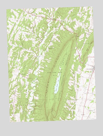
Meadow Grounds, PA USGS Topographic Map
Click on map above to begin viewing in our Map Viewer.

This topographic map contains these locations and features:
Feature Name Type Latitude Longitude GNIS ID View Map
AndoverPopulated PlaceN39.9465°W78.0839°1202977View Map
Asbury ChurchChurchN39.9923°W78.0831°1168440View Map
Baby RunStreamN39.9640°W78.0739°1168549View Map
Back RunStreamN39.8779°W78.0369°1168561View Map
Bethlehem ChurchChurchN39.9698°W78.0072°1169430View Map
Big Spring CemeteryCemeteryN39.8849°W78.0073°1169593View Map
Breezy PointPopulated PlaceN39.9848°W78.0461°1203145View Map
Ditch RunStreamN39.9587°W78.1233°1173304View Map
Fulton CountyCivilN39.9253°W78.1127°1213671View Map
Fulton County Medical CenterHospitalN39.9312°W78.0013°2718015View Map
Green HillPopulated PlaceN39.9940°W78.0853°1176072View Map
HarrisonvillePopulated PlaceN39.9876°W78.0594°1176590View Map
Harrisonville Post OfficePost OfficeN39.9875°W78.0601°2779659View Map
Joes RunStreamN39.8820°W78.0978°1178095View Map
Kendall RunStreamN39.9034°W78.0161°1178354View Map
Lick HollowValleyN39.9574°W78.1027°1179283View Map
Meadow GroundsBasinN39.9273°W78.0525°1180822View Map
Meadow Grounds DamDamN39.9168°W78.0497°1194418View Map
Meadow Grounds LakeReservoirN39.9141°W78.0546°1180823View Map
Meadow Grounds MountainSummitN39.9404°W78.0383°1180824View Map
Owl CreekStreamN39.9420°W78.0803°1183153View Map
Patterson RunStreamN39.9470°W78.0775°1183376View Map
Pleasant RidgePopulated PlaceN39.9281°W78.1075°1204420View Map
Pleasant RidgeRidgeN39.9243°W78.1095°1184050View Map
Pleasant Ridge ChurchChurchN39.8848°W78.1200°1184051View Map
Rock Hill ChurchChurchN39.8979°W78.0281°1185256View Map
Scrub RidgeRidgeN39.8926°W78.0714°1187182View Map
Siloam ChurchChurchN39.9643°W78.0742°1187666View Map
Sindeldecker BranchStreamN39.9887°W78.0583°1198161View Map
State Game Lands Number 53ParkN39.9240°W78.0578°1188516View Map
Strawberry RidgeRidgeN39.8862°W78.0328°1188866View Map
SummitSummitN39.9684°W78.0228°1189038View Map
The Supreme Council of the House of JacobChurchN39.9556°W78.0653°1189450View Map
Township of AyrCivilN39.8773°W78.0269°1216474View Map
Township of Licking CreekCivilN39.9764°W78.0838°1216479View Map
Union ChurchChurchN39.8809°W78.0186°1190130View Map
Wink CemeteryCemeteryN39.8926°W78.0950°1191600View Map

Note: Coordinates in the location and feature list above are referenced to NAD83 datum.


Copyright (C) 2008-2024 Ryan Niemi / Sunset Dynamics ... All Rights Reserved