TopoQuest Logo
Do you find TopoQuest useful?
Help keep TopoQuest running and adding new maps/features by donating!
Bitcoin:  19c7KJd3qBynnjoSw5npx9KScwjBe4ifkT
Litecoin:  LXs6TkuXGGXo1vDsWCkWVdjQX94eUKd6ui
Home View Maps Find Maps Find Places Resources & Links


Marshville, North Carolina Topographic Map

USGS Map Title: Marshville, NC
USGS Map MRC: 34080H3
DRG (GeoTIFF) Download: o34080h3.tif


Neighboring USGS Topographic Map Quads:


  Watson, NC  
35080A4
 

  Olive Branch, NC  
35080A3
 

  Polkton, NC  
35080A2
 

  Wingate, NC  
34080H4
 

  Marshville, NC  
34080H3
 

  Russellville, NC  
34080H2
 

  Pageland, SC  
34080G4
 

  Hornsboro, SC  
34080G3
 

  Mount Croghan, SC  
34080G2


Map MRC Location:

N35°
W81°
N35°
W80°
H8 H7 H6 H5 H4 H3 H2 H1
G8 G7 G6 G5 G4 G3 G2 G1
F8 F7 F6 F5 F4 F3 F2 F1
E8 E7 E6 E5 E4 E3 E2 E1
D8 D7 D6 D5 D4 D3 D2 D1
C8 C7 C6 C5 C4 C3 C2 C1
B8 B7 B6 B5 B4 B3 B2 B1
A8 A7 A6 A5 A4 A3 A2 A1
N34°
W81°
N34°
W80°

Marshville, NC USGS 1:24K Topographic Map Preview:
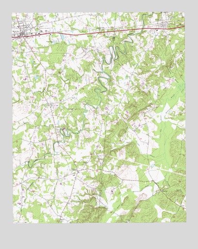
Marshville, NC USGS Topographic Map
Click on map above to begin viewing in our Map Viewer.

This topographic map contains these locations and features:
Feature Name Type Latitude Longitude GNIS ID View Map
Barkers BranchStreamN34.9307°W80.3353°980557View Map
Beaver Lane Volunteer Rescue and Fire Department Station 8BuildingN34.9887°W80.3642°2638527View Map
Beaverdam CreekStreamN34.9646°W80.3095°980846View Map
Bethel ChurchChurchN34.9299°W80.3420°981114View Map
Bethel Church CemeteryCemeteryN34.9296°W80.3418°2778893View Map
Big BranchStreamN34.9560°W80.2534°981326View Map
Black Jack BranchStreamN34.9168°W80.2648°981532View Map
Brown FieldAirportN34.8923°W80.3706°2679222View Map
Cool Spring BranchStreamN34.9157°W80.3442°983485View Map
Flint Ridge ChurchChurchN34.9424°W80.3312°985219View Map
Flint Ridge Church CemeteryCemeteryN34.9428°W80.3301°2778894View Map
Gilboa ChurchChurchN34.9465°W80.3473°985681View Map
Gilboa Methodist Church CemeteryCemeteryN34.9466°W80.3468°2778895View Map
High Ridge ChurchChurchN34.9102°W80.3228°986760View Map
High Ridge Church CemeteryCemeteryN34.9100°W80.3231°2778891View Map
Key BranchStreamN34.9454°W80.2642°987946View Map
Lanes Creek ChurchChurchN34.9863°W80.3170°988134View Map
Lick BranchStreamN34.9713°W80.3092°988444View Map
Marsh LakeReservoirN34.9618°W80.3570°998240View Map
Marsh Lake DamDamN34.9635°W80.3581°998241View Map
MarshvillePopulated PlaceN34.9885°W80.3670°989388View Map
Marshville City CemeteryCemeteryN34.9992°W80.3705°2778897View Map
Marshville Police DepartmentBuildingN34.9870°W80.3690°2769688View Map
Marshville Post OfficePost OfficeN34.9891°W80.3650°2774076View Map
Meltonville CemeteryCemeteryN34.8753°W80.2915°2778994View Map
Meltonville ChurchChurchN34.8757°W80.2912°989715View Map
Mount Carmel ChurchChurchN34.9610°W80.2901°990347View Map
Mount Moriah ChurchChurchN34.8763°W80.3406°990435View Map
Mount Moriah Church CemeteryCemeteryN34.8765°W80.3400°2778889View Map
New Zion ChurchChurchN34.9999°W80.2626°991115View Map
Norkett BranchStreamN34.9135°W80.3520°991178View Map
PeachlandPopulated PlaceN34.9938°W80.2645°991978View Map
Peachland Fire District of Anson CountyBuildingN34.9932°W80.2651°2638836View Map
Peachland Post OfficePost OfficeN34.9931°W80.2662°2774225View Map
Pine View CemeteryCemeteryN34.9857°W80.2626°992297View Map
Rushing BranchStreamN34.9015°W80.2642°993815View Map
Stegall LakeReservoirN34.9835°W80.3381°998267View Map
Stegall Lake DamDamN34.9835°W80.3381°998266View Map
Sturdivants CrossroadsPopulated PlaceN34.9060°W80.3281°1006383View Map
Town of MarshvilleCivilN34.9857°W80.3712°2406104View Map
Town of PeachlandCivilN34.9931°W80.2660°2407085View Map
Township of MarshvilleCivilN34.9815°W80.3679°1027245View Map
White StoreLocaleN34.8938°W80.2678°997219View Map
Wide Mouth BranchStreamN34.9854°W80.2909°997287View Map
William Malachai Rushing CemeteryCemeteryN34.9150°W80.3124°2778892View Map

Note: Coordinates in the location and feature list above are referenced to NAD83 datum.


Copyright (C) 2008-2024 Ryan Niemi / Sunset Dynamics ... All Rights Reserved