TopoQuest Logo
Do you find TopoQuest useful?
Help keep TopoQuest running and adding new maps/features by donating!
Bitcoin:  19c7KJd3qBynnjoSw5npx9KScwjBe4ifkT
Litecoin:  LXs6TkuXGGXo1vDsWCkWVdjQX94eUKd6ui
Home View Maps Find Maps Find Places Resources & Links


Watson, North Carolina Topographic Map

USGS Map Title: Watson, NC
USGS Map MRC: 35080A4
DRG (GeoTIFF) Download: o35080a4.tif


Neighboring USGS Topographic Map Quads:


  Midland, NC  
35080B5
 

  Stanfield, NC  
35080B4
 

  Oakboro, NC  
35080B3
 

  Bakers, NC  
35080A5
 

  Watson, NC  
35080A4
 

  Olive Branch, NC  
35080A3
 

  Monroe, NC  
34080H5
 

  Wingate, NC  
34080H4
 

  Marshville, NC  
34080H3


Map MRC Location:

N36°
W81°
N36°
W80°
H8 H7 H6 H5 H4 H3 H2 H1
G8 G7 G6 G5 G4 G3 G2 G1
F8 F7 F6 F5 F4 F3 F2 F1
E8 E7 E6 E5 E4 E3 E2 E1
D8 D7 D6 D5 D4 D3 D2 D1
C8 C7 C6 C5 C4 C3 C2 C1
B8 B7 B6 B5 B4 B3 B2 B1
A8 A7 A6 A5 A4 A3 A2 A1
N35°
W81°
N35°
W80°

Watson, NC USGS 1:24K Topographic Map Preview:
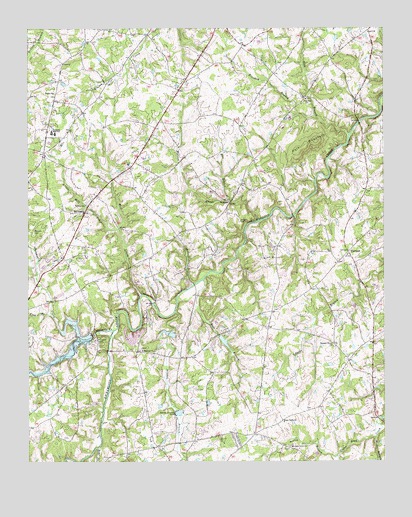
Watson, NC USGS Topographic Map
Click on map above to begin viewing in our Map Viewer.

This topographic map contains these locations and features:
Feature Name Type Latitude Longitude GNIS ID View Map
Arant AirportAirportN35.0569°W80.4510°2679283View Map
Austin BranchStreamN35.0024°W80.3912°980372View Map
Austin Grove Baptist Church CemeteryCemeteryN35.0037°W80.4078°2778904View Map
Austin Grove ChurchChurchN35.0043°W80.4073°980374View Map
Brandon BranchStreamN35.0996°W80.3990°981827View Map
Brewer LakeReservoirN35.0347°W80.4310°998327View Map
Brewer Lake DamDamN35.0368°W80.4331°998328View Map
Buck BranchStreamN35.0074°W80.3778°982098View Map
Bull BranchStreamN35.0524°W80.4381°982195View Map
Chinkapin CreekStreamN35.0351°W80.4806°983145View Map
FairfieldPopulated PlaceN35.0604°W80.3873°984898View Map
Fairfield Baptist Church CemeteryCemeteryN35.0596°W80.3869°2778851View Map
Flag BranchStreamN35.0424°W80.4917°985141View Map
Gold BranchStreamN35.0943°W80.3870°985766View Map
Haw BranchStreamN35.0760°W80.4295°986506View Map
Josiah Austin CemeteryCemeteryN35.1148°W80.4110°2778853View Map
Lake TwittyReservoirN35.0287°W80.4915°998330View Map
Lake TwittyReservoirN35.0368°W80.4745°995500View Map
Little Mill CreekStreamN35.0671°W80.4678°988705View Map
Mc Donald FieldAirportN35.0535°W80.4090°2679221View Map
Meadow BranchStreamN35.0432°W80.4481°989668View Map
Midway Baptist Church CemeteryCemeteryN35.0325°W80.4595°2776570View Map
Midway ChurchChurchN35.0321°W80.4598°989823View Map
Mill CreekStreamN35.0479°W80.4603°989915View Map
Mill Creek Baptist Church CemeteryCemeteryN35.0724°W80.4789°2776569View Map
Mill Creek ChurchChurchN35.0718°W80.4803°989961View Map
New Hope Baptist Church CemeteryCemeteryN35.1045°W80.4015°2778852View Map
New Hope ChurchChurchN35.1046°W80.4023°990997View Map
Piedmont High SchoolSchoolN35.0951°W80.4912°992163View Map
Piney Grove ChurchChurchN35.0115°W80.4101°992340View Map
Piney Grove Church CemeteryCemeteryN35.0117°W80.4130°2778903View Map
Pleasant Grove ChurchChurchN35.0335°W80.3928°992468View Map
Pleasant Grove Church CemeteryCemeteryN35.0331°W80.3924°2778905View Map
Polk MountainSummitN35.0924°W80.3984°1022024View Map
Presson - Shelby CemeteryCemeteryN35.0665°W80.4977°992790View Map
Rays ForkStreamN35.0038°W80.4756°993085View Map
Shiloh Advent Church CemeteryCemeteryN35.1059°W80.4908°2778855View Map
Shiloh ChurchChurchN35.1065°W80.4906°994688View Map
Spring BranchStreamN35.0015°W80.4453°995322View Map
Stewarts CreekStreamN35.0379°W80.4698°995503View Map
Strawn - Treadway CemeteryCemeteryN35.0151°W80.4014°2778902View Map
Twitty DamDamN35.0368°W80.4781°998329View Map
WatsonPopulated PlaceN35.0749°W80.4290°996862View Map
Watson CreekStreamN35.0696°W80.4192°996869View Map
Williams CemeteryCemeteryN35.0695°W80.4255°997365View Map
Wingate Community Church of God CemeteryCemeteryN35.0066°W80.4301°2776572View Map

Note: Coordinates in the location and feature list above are referenced to NAD83 datum.


Copyright (C) 2008-2024 Ryan Niemi / Sunset Dynamics ... All Rights Reserved