TopoQuest Logo
Do you find TopoQuest useful?
Help keep TopoQuest running and adding new maps/features by donating!
Bitcoin:  19c7KJd3qBynnjoSw5npx9KScwjBe4ifkT
Litecoin:  LXs6TkuXGGXo1vDsWCkWVdjQX94eUKd6ui
Home View Maps Find Maps Find Places Resources & Links


Lyons, Indiana Topographic Map

USGS Map Title: Lyons, IN
USGS Map MRC: 38087H1
DRG (GeoTIFF) Download: o38087h1.tif


Neighboring USGS Topographic Map Quads:


  Linton, IN  
39087A2
 

  Switz City, IN  
39087A1
 

  Bloomfield, IN  
39086A8
 

  Sandborn, IN  
38087H2
 

  Lyons, IN  
38087H1
 

  Scotland, IN  
38086H8
 

  Plainville, IN  
38087G2
 

  Epsom, IN  
38087G1
 

  Odon, IN  
38086G8


Map MRC Location:

N39°
W88°
N39°
W87°
H8 H7 H6 H5 H4 H3 H2 H1
G8 G7 G6 G5 G4 G3 G2 G1
F8 F7 F6 F5 F4 F3 F2 F1
E8 E7 E6 E5 E4 E3 E2 E1
D8 D7 D6 D5 D4 D3 D2 D1
C8 C7 C6 C5 C4 C3 C2 C1
B8 B7 B6 B5 B4 B3 B2 B1
A8 A7 A6 A5 A4 A3 A2 A1
N38°
W88°
N38°
W87°

Lyons, IN USGS 1:24K Topographic Map Preview:
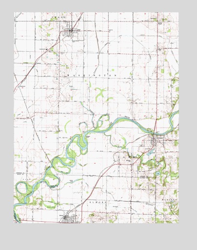
Lyons, IN USGS Topographic Map
Click on map above to begin viewing in our Map Viewer.

This topographic map contains these locations and features:
Feature Name Type Latitude Longitude GNIS ID View Map
BeehunterPopulated PlaceN38.9562°W87.1211°430740View Map
Beehunter DitchCanalN38.9939°W87.1236°430741View Map
Benham AirportAirportN38.9758°W87.0232°2676977View Map
Birch BedBasinN38.9345°W87.0703°446867View Map
Bogard CemeteryCemeteryN38.9456°W87.0050°431286View Map
Brewer HillSummitN38.9123°W87.0358°431497View Map
Buck CreekStreamN38.9970°W87.1236°431726View Map
BushrodPopulated PlaceN38.9689°W87.1089°431891View Map
Dixon DitchCanalN38.9514°W87.0678°433583View Map
Elmore PondSwampN38.8843°W87.0971°434133View Map
ElnoraPopulated PlaceN38.8784°W87.0858°434139View Map
Elnora Police DepartmentBuildingN38.8786°W87.0867°2758286View Map
Fairview CemeteryCemeteryN38.8759°W87.0661°434316View Map
First CreekStreamN38.9289°W87.0564°434498View Map
Fourmile CreekStreamN38.9300°W87.0658°434724View Map
Grindstone BranchStreamN38.8962°W87.0970°435509View Map
IlenePopulated PlaceN38.9375°W87.1125°436707View Map
Ilene DitchCanalN38.9339°W87.1103°436708View Map
Indian PondLakeN38.9000°W87.0792°436778View Map
L and M Elementary and High SchoolSchoolN38.9778°W87.1000°446970View Map
Long BedBasinN38.9398°W87.0722°446866View Map
LyonsPopulated PlaceN38.9892°W87.0822°438441View Map
Lyons Police DepartmentBuildingN38.9887°W87.0808°2758289View Map
Lyons Volunteer Fire DepartmentBuildingN38.9892°W87.0892°2625707View Map
Maumee HillSummitN38.8823°W87.0042°438742View Map
Mc Kee DitchCanalN38.9556°W87.0795°438891View Map
Morgan HillCliffN38.9273°W87.0706°439432View Map
Mount Zion CemeteryCemeteryN38.9759°W87.0900°439731View Map
Mud Pike ChurchChurchN38.8887°W87.0353°439840View Map
Nail BedBasinN38.9045°W87.0864°439928View Map
Nedigh DitchCanalN38.9731°W87.0033°439967View Map
NewberryPopulated PlaceN38.9250°W87.0195°440136View Map
Old Slinkard CemeteryCemeteryN38.9084°W87.0181°440597View Map
Prairie ChapelChurchN38.9781°W87.0158°441534View Map
Ramsey DitchCanalN38.9400°W87.1178°441758View Map
Simpson DitchCanalN38.9862°W87.0195°443537View Map
Simpson HillSummitN38.9953°W87.0150°443538View Map
Sipes BedBasinN38.9089°W87.0725°443554View Map
Slinkard CemeteryCemeteryN38.9212°W87.0267°443608View Map
Stalcup CornerPopulated PlaceN38.9945°W87.0161°452084View Map
Timmons DitchCanalN38.9753°W87.0222°444768View Map
Town of ElnoraCivilN38.8761°W87.0848°2396927View Map
Town of LyonsCivilN38.9879°W87.0813°2396731View Map
Town of NewberryCivilN38.9237°W87.0190°2396811View Map
Township of CassCivilN38.9254°W87.0096°453164View Map
Township of WashingtonCivilN38.9625°W87.0566°453997View Map
Vertrees DitchCanalN38.8889°W87.0672°445262View Map
Weaver DitchCanalN38.8962°W87.0600°445604View Map
Wells DitchCanalN38.9695°W87.1117°445666View Map
Woodhouse BranchStreamN38.9284°W87.0095°446286View Map

Note: Coordinates in the location and feature list above are referenced to NAD83 datum.


Copyright (C) 2008-2024 Ryan Niemi / Sunset Dynamics ... All Rights Reserved