TopoQuest Logo
Do you find TopoQuest useful?
Help keep TopoQuest running and adding new maps/features by donating!
Bitcoin:  19c7KJd3qBynnjoSw5npx9KScwjBe4ifkT
Litecoin:  LXs6TkuXGGXo1vDsWCkWVdjQX94eUKd6ui
Home View Maps Find Maps Find Places Resources & Links


Grove Oak, Alabama Topographic Map

USGS Map Title: Grove Oak, AL
USGS Map MRC: 34086D1
DRG (GeoTIFF) Download: o34086d1.tif


Neighboring USGS Topographic Map Quads:


  Swearengin, AL  
34086E2
 

  Langston, AL  
34086E1
 

  Dutton, AL  
34085E8
 

  Columbus City, AL  
34086D2
 

  Grove Oak, AL  
34086D1
 

  Fyffe, AL  
34085D8
 

  Albertville, AL  
34086C2
 

  Painter, AL  
34086C1
 

  Crossville, AL  
34085C8


Map MRC Location:

N35°
W87°
N35°
W86°
H8 H7 H6 H5 H4 H3 H2 H1
G8 G7 G6 G5 G4 G3 G2 G1
F8 F7 F6 F5 F4 F3 F2 F1
E8 E7 E6 E5 E4 E3 E2 E1
D8 D7 D6 D5 D4 D3 D2 D1
C8 C7 C6 C5 C4 C3 C2 C1
B8 B7 B6 B5 B4 B3 B2 B1
A8 A7 A6 A5 A4 A3 A2 A1
N34°
W87°
N34°
W86°

Grove Oak, AL USGS 1:24K Topographic Map Preview:
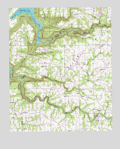
Grove Oak, AL USGS Topographic Map
Click on map above to begin viewing in our Map Viewer.

This topographic map contains these locations and features:
Feature Name Type Latitude Longitude GNIS ID View Map
Banks BranchStreamN34.4870°W86.0694°139090View Map
Berry BranchStreamN34.4634°W86.0922°113957View Map
Bethel ChurchChurchN34.3779°W86.1105°150091View Map
Bethlehem SchoolSchoolN34.4595°W86.0133°150095View Map
Bethune PointCapeN34.4584°W86.0839°114162View Map
Beulah Church (historical)ChurchN34.3965°W86.1183°157516View Map
Black Oak BranchStreamN34.4176°W86.0405°150113View Map
Black Oak ChurchChurchN34.4309°W86.0283°150114View Map
Black Oak CreekStreamN34.4290°W86.1091°154989View Map
Bucks PocketValleyN34.4812°W86.0880°150132View Map
Bucks Pocket Tri-County ParkParkN34.4709°W86.0644°115148View Map
Cart BranchStreamN34.4240°W86.0600°150147View Map
Center Point CemeteryCemeteryN34.4637°W86.1147°147466View Map
Center Point ChurchChurchN34.4640°W86.1153°115859View Map
Chigger HillPopulated PlaceN34.3976°W86.0164°150154View Map
Cooks BranchStreamN34.4845°W86.0830°116539View Map
Dry CreekStreamN34.4843°W86.0825°117586View Map
Ebenezer ChurchChurchN34.4154°W86.0400°150215View Map
Elrods BridgeBridgeN34.3909°W86.0186°150683View Map
Elrods Mill (historical)LocaleN34.3923°W86.0166°150684View Map
Flat Rock ChurchChurchN34.4104°W86.0539°150231View Map
Flat Rock School (historical)SchoolN34.4104°W86.0533°1729814View Map
Glade BranchStreamN34.4298°W86.0289°150256View Map
Godwin PointCapeN34.4970°W86.0703°119080View Map
Graham BranchStreamN34.4270°W86.0314°150260View Map
Grove OakPopulated PlaceN34.4381°W86.0525°150268View Map
Grove Oak Post OfficePost OfficeN34.4373°W86.0533°168375View Map
Grove Oak SchoolSchoolN34.4395°W86.0525°163224View Map
Grove Oak Volunteer Fire DepartmentBuildingN34.4397°W86.0533°2683429View Map
Haigwood BranchStreamN34.4818°W86.0155°119546View Map
Hall BranchStreamN34.4240°W86.0222°150271View Map
High FallsFallsN34.4001°W86.0680°150289View Map
High Falls Bridge (historical)BridgeN34.3995°W86.0666°157522View Map
High Falls Natural BridgeArchN34.4000°W86.0675°2571543View Map
Hilley PointCapeN34.4776°W86.0716°120127View Map
Hillian Store (historical)LocaleN34.4926°W86.1203°139400View Map
Jink (historical)Populated PlaceN34.3909°W86.1116°139408View Map
Leather Hole BranchStreamN34.4537°W86.0853°150329View Map
Lewis BranchStreamN34.4815°W86.0016°150331View Map
Little Sauty CreekStreamN34.4748°W86.0530°150344View Map
Middle PointCapeN34.4709°W86.0155°150379View Map
Morgan CoveValleyN34.4648°W86.0911°123041View Map
Morgans Store (historical)LocaleN34.4529°W86.1014°139439View Map
Mormon HoleBasinN34.4420°W86.1119°123054View Map
Mormon Hole BranchStreamN34.4423°W86.1114°123055View Map
Mount Moriah Church (historical)ChurchN34.3948°W86.0200°1729815View Map
Mount Nebo ChurchChurchN34.4373°W86.0091°150398View Map
Mount Pleasant CemeteryCemeteryN34.4123°W86.0394°1730310View Map
Mount Pleasant ChurchChurchN34.4126°W86.0394°150403View Map
New Harmony ChurchChurchN34.3943°W86.1080°150421View Map
New Harmony School (historical)SchoolN34.3945°W86.0928°1729816View Map
New Hope ChurchChurchN34.3968°W86.0178°150426View Map
Old Beulah Church (historical)ChurchN34.3968°W86.1186°1729817View Map
Pendergrass (historical)Populated PlaceN34.4523°W86.1019°1729827View Map
Pine BranchStreamN34.3937°W86.0333°150455View Map
Piney Grove CemeteryCemeteryN34.4401°W86.0816°1730319View Map
Piney Grove ChurchChurchN34.4404°W86.0803°152945View Map
Piney School (historical)SchoolN34.4395°W86.0808°150731View Map
Point RockPillarN34.4740°W86.0455°150462View Map
Poplar Springs ChurchChurchN34.4043°W86.1250°125173View Map
Prospect ChurchChurchN34.4409°W86.0625°150471View Map
Redbud PointCapeN34.4351°W86.1108°125502View Map
Salem ChurchChurchN34.4934°W86.0416°126252View Map
Salem School (historical)SchoolN34.4929°W86.0422°139272View Map
South HillPopulated PlaceN34.4104°W86.0383°157088View Map
The NarrowsGapN34.4531°W86.1025°127828View Map
Thirtynine (historical)Populated PlaceN34.4629°W86.0114°150749View Map
Tucker CoveValleyN34.4554°W86.0978°150561View Map
Upton BranchStreamN34.3909°W86.0100°153821View Map
Welcome Hill ChurchChurchN34.4123°W86.0605°150752View Map
Wheeler HollowValleyN34.4423°W86.1094°150586View Map
Wilborn BranchStreamN34.4879°W86.0153°128949View Map
Yellow CreekStreamN34.4984°W86.1091°129290View Map

Note: Coordinates in the location and feature list above are referenced to NAD83 datum.


Copyright (C) 2008-2024 Ryan Niemi / Sunset Dynamics ... All Rights Reserved