TopoQuest Logo
Do you find TopoQuest useful?
Help keep TopoQuest running and adding new maps/features by donating!
Bitcoin:  19c7KJd3qBynnjoSw5npx9KScwjBe4ifkT
Litecoin:  LXs6TkuXGGXo1vDsWCkWVdjQX94eUKd6ui
Home View Maps Find Maps Find Places Resources & Links


Columbus City, Alabama Topographic Map

USGS Map Title: Columbus City, AL
USGS Map MRC: 34086D2
DRG (GeoTIFF) Download: o34086d2.tif


Neighboring USGS Topographic Map Quads:


  Grant, AL  
34086E3
 

  Swearengin, AL  
34086E2
 

  Langston, AL  
34086E1
 

  Mount Carmel, AL  
34086D3
 

  Columbus City, AL  
34086D2
 

  Grove Oak, AL  
34086D1
 

  Guntersville, AL  
34086C3
 

  Albertville, AL  
34086C2
 

  Painter, AL  
34086C1


Map MRC Location:

N35°
W87°
N35°
W86°
H8 H7 H6 H5 H4 H3 H2 H1
G8 G7 G6 G5 G4 G3 G2 G1
F8 F7 F6 F5 F4 F3 F2 F1
E8 E7 E6 E5 E4 E3 E2 E1
D8 D7 D6 D5 D4 D3 D2 D1
C8 C7 C6 C5 C4 C3 C2 C1
B8 B7 B6 B5 B4 B3 B2 B1
A8 A7 A6 A5 A4 A3 A2 A1
N34°
W87°
N34°
W86°

Columbus City, AL USGS 1:24K Topographic Map Preview:
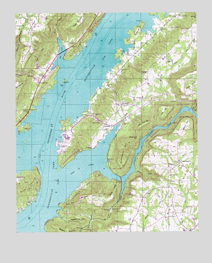
Columbus City, AL USGS Topographic Map
Click on map above to begin viewing in our Map Viewer.

This topographic map contains these locations and features:
Feature Name Type Latitude Longitude GNIS ID View Map
Alabama Christian Youth CampLocaleN34.4548°W86.2297°148886View Map
Alexander SubdivisionPopulated PlaceN34.4648°W86.2325°148890View Map
AsburyPopulated PlaceN34.3781°W86.1261°1729820View Map
Asbury Methodist ChurchChurchN34.3754°W86.1308°113245View Map
Bailey RidgeRidgeN34.3981°W86.1830°113360View Map
Bryant Mill HollowValleyN34.4840°W86.2203°115092View Map
Buck Island (historical)IslandN34.4181°W86.2319°139353View Map
Buck Island BarBarN34.4168°W86.2291°139354View Map
Camp Ney A TiLocaleN34.4573°W86.2258°148887View Map
Camp TricoLocaleN34.4651°W86.2236°148889View Map
Campbell MillPopulated PlaceN34.4931°W86.2441°156146View Map
Cedar RidgeRidgeN34.3909°W86.2128°115812View Map
Center PointSummitN34.4604°W86.1355°115854View Map
Center Star ChurchChurchN34.4720°W86.2264°139356View Map
Chandler BranchStreamN34.4679°W86.2258°115935View Map
Chandler CemeteryCemeteryN34.4606°W86.2178°115937View Map
Columbus BarBarN34.4556°W86.2158°139364View Map
Columbus CityPopulated PlaceN34.4606°W86.2333°116461View Map
Columbus City Ferry (historical)CrossingN34.4598°W86.2125°139365View Map
Columbus City Landing (historical)LocaleN34.4576°W86.2178°139366View Map
Columbus City School (historical)SchoolN34.4654°W86.2308°1729821View Map
Cooper CemeteryCemeteryN34.4334°W86.1894°116579View Map
Duvall BranchStreamN34.4454°W86.1289°117704View Map
Ellenburg MountainSummitN34.3781°W86.2233°117938View Map
Fairview CemeteryCemeteryN34.4906°W86.1303°118137View Map
Fairview ChurchChurchN34.4926°W86.1308°139374View Map
Fairview Church (historical)ChurchN34.4912°W86.1297°1729822View Map
Five PointsPopulated PlaceN34.4473°W86.1772°156355View Map
Five Points School (historical)SchoolN34.4506°W86.1766°149240View Map
Glen HavenPopulated PlaceN34.4820°W86.2208°148888View Map
Graveyard HillSummitN34.3812°W86.2039°119282View Map
Gunters BarBarN34.4862°W86.1958°139391View Map
Haney ChapelChurchN34.4373°W86.1922°119677View Map
Haney Chapel CemeteryCemeteryN34.4420°W86.1966°119678View Map
Haney Chapel School (historical)SchoolN34.4370°W86.1916°1729823View Map
Haney Chapel School Number 2 (historical)SchoolN34.4281°W86.2144°1729824View Map
Harrison Reservation (historical)CivilN34.4454°W86.2408°119823View Map
Henrys BarBarN34.3876°W86.2361°139398View Map
High Point ChurchChurchN34.4129°W86.1411°120063View Map
Hurricane BranchStreamN34.4037°W86.1766°120575View Map
John Doss MountainSummitN34.4354°W86.1655°120910View Map
Johnson CemeteryCemeteryN34.4842°W86.1714°163839View Map
Johnson CemeteryCemeteryN34.4837°W86.1714°120941View Map
Johnson HollowValleyN34.4093°W86.1680°120952View Map
Johnsons Store (historical)LocaleN34.4579°W86.1633°139410View Map
Kennamer CemeteryCemeteryN34.4340°W86.2439°121141View Map
King Chapel (historical)SchoolN34.3851°W86.2208°1729825View Map
King Chapel CemeteryCemeteryN34.3818°W86.2141°121218View Map
Kirby CemeteryCemeteryN34.4434°W86.1264°121247View Map
Lake Guntersville State ParkParkN34.4029°W86.1964°151977View Map
Law Landing (historical)LocaleN34.4618°W86.2089°139417View Map
Little MountainSummitN34.4462°W86.1500°121820View Map
Little Mountain MarinaLocaleN34.4609°W86.1880°139423View Map
Little New YorkPopulated PlaceN34.3879°W86.1858°156616View Map
Lovelace Landing (historical)LocaleN34.3909°W86.2303°139426View Map
Lower BarBarN34.4668°W86.2083°139425View Map
McCorkle MountainSummitN34.4540°W86.2486°122494View Map
McDonald SpringSpringN34.4673°W86.2450°149247View Map
MeltonsvillePopulated PlaceN34.4351°W86.1900°156699View Map
Mid (historical)Populated PlaceN34.4620°W86.1583°139437View Map
Mill CreekBayN34.4768°W86.2183°122749View Map
Miller SubdivisionPopulated PlaceN34.4706°W86.2266°148891View Map
Minky CreekStreamN34.4368°W86.1789°122872View Map
Mount High Primitive Baptist ChurchChurchN34.4070°W86.1441°152426View Map
Mount Moriah CemeteryCemeteryN34.4656°W86.1625°147484View Map
Mount Moriah Methodist ChurchChurchN34.4654°W86.1630°152449View Map
Mount Moriah School (historical)SchoolN34.4654°W86.1625°1729826View Map
Mount Moriah School (historical)SchoolN34.4568°W86.1622°139441View Map
Murphy HillSummitN34.4909°W86.1661°123604View Map
Negro MountainSummitN34.4965°W86.2039°123686View Map
Old Union BranchStreamN34.4984°W86.2400°124264View Map
Pine Island (historical)IslandN34.4868°W86.1894°139462View Map
Pine Island ChurchChurchN34.4848°W86.2086°139463View Map
Pine Island Landing (historical)LocaleN34.4890°W86.1958°139464View Map
Pine Island SubdivisionPopulated PlaceN34.4784°W86.2072°148892View Map
Poplar SpringsPopulated PlaceN34.4145°W86.1369°125164View Map
Poplar Springs ChurchChurchN34.4048°W86.1255°139466View Map
Poplar Springs School (historical)SchoolN34.4118°W86.1405°1729828View Map
Poplar Springs School (historical)SchoolN34.4156°W86.1378°149252View Map
Prospect CemeteryCemeteryN34.4815°W86.2116°125304View Map
Prospect ChurchChurchN34.4820°W86.2105°139468View Map
Rainey CemeteryCemeteryN34.4912°W86.1400°125420View Map
Rooks CemeteryCemeteryN34.3834°W86.1408°125922View Map
Sandridge ChurchChurchN34.4981°W86.1258°126359View Map
Smith CemeteryCemeteryN34.4490°W86.1391°127004View Map
Smith GapGapN34.4523°W86.1330°127020View Map
Star Point SubdivisionPopulated PlaceN34.4370°W86.2166°148863View Map
Stubblefield MountainSummitN34.4201°W86.1791°127479View Map
Sycamore Landing (historical)LocaleN34.4748°W86.1991°139492View Map
TanglewoodPopulated PlaceN34.4912°W86.1961°148893View Map
Taylor MountainSummitN34.3965°W86.1989°127744View Map
The NarrowsGapN34.4651°W86.2430°127829View Map
Thomason CemeteryCemeteryN34.4979°W86.1372°127880View Map
Town CreekStreamN34.4043°W86.2214°150555View Map
Town Creek DivisionCivilN34.4212°W86.1555°165889View Map
Town Creek Ferry (historical)CrossingN34.3840°W86.2258°1729829View Map
Turner MarinaLocaleN34.4695°W86.2244°139495View Map
Village Ford GapGapN34.4290°W86.1664°128451View Map
Wakefield Community CenterBuildingN34.4526°W86.1753°139501View Map
Wakefield Volunteer Fire DepartmentBuildingN34.4520°W86.1756°2682937View Map
Waterfront Fire DepartmentBuildingN34.4881°W86.2031°2683243View Map
Williams PointCapeN34.4359°W86.1325°129030View Map
Winston GapGapN34.4293°W86.1408°129125View Map
Woosley CemeteryCemeteryN34.4729°W86.1447°129232View Map

Note: Coordinates in the location and feature list above are referenced to NAD83 datum.


Copyright (C) 2008-2024 Ryan Niemi / Sunset Dynamics ... All Rights Reserved