TopoQuest Logo
Do you find TopoQuest useful?
Help keep TopoQuest running and adding new maps/features by donating!
Bitcoin:  19c7KJd3qBynnjoSw5npx9KScwjBe4ifkT
Litecoin:  LXs6TkuXGGXo1vDsWCkWVdjQX94eUKd6ui
Home View Maps Find Maps Find Places Resources & Links


Gamaliel, Arkansas Topographic Map

USGS Map Title: Gamaliel, AR
USGS Map MRC: 36092D2
DRG (GeoTIFF) Download: o36092d2.tif


Neighboring USGS Topographic Map Quads:


  Udall, MO  
36092E3
 

  Bakersfield, MO  
36092E2
 

  Caulfield, MO  
36092E1
 

  Clarkridge, AR  
36092D3
 

  Gamaliel, AR  
36092D2
 

  Gepp, AR  
36092D1
 

  Mountain Home East, AR  
36092C3
 

  Norfork Dam North, AR  
36092C2
 

  Elizabeth, AR  
36092C1


Map MRC Location:

N37°
W93°
N37°
W92°
H8 H7 H6 H5 H4 H3 H2 H1
G8 G7 G6 G5 G4 G3 G2 G1
F8 F7 F6 F5 F4 F3 F2 F1
E8 E7 E6 E5 E4 E3 E2 E1
D8 D7 D6 D5 D4 D3 D2 D1
C8 C7 C6 C5 C4 C3 C2 C1
B8 B7 B6 B5 B4 B3 B2 B1
A8 A7 A6 A5 A4 A3 A2 A1
N36°
W93°
N36°
W92°

Gamaliel, AR USGS 1:24K Topographic Map Preview:
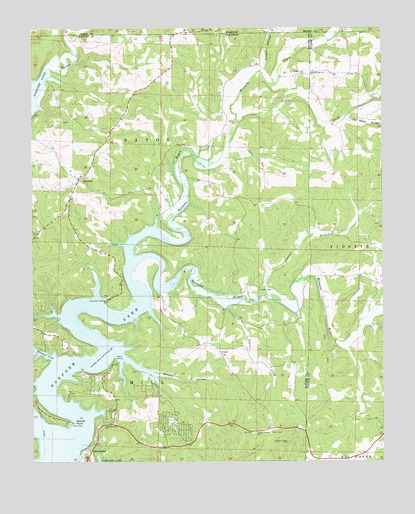
Gamaliel, AR USGS Topographic Map
Click on map above to begin viewing in our Map Viewer.

This topographic map contains these locations and features:
Feature Name Type Latitude Longitude GNIS ID View Map
Athens CemeteryCemeteryN36.4248°W92.1696°45964View Map
Barren CreekStreamN36.4882°W92.2427°46118View Map
Bennetts (historical)Populated PlaceN36.4648°W92.1904°69341View Map
Bennetts BayouStreamN36.4334°W92.2157°46386View Map
Bennetts RiverStreamN36.4287°W92.1984°46387View Map
Bidwell PointCapeN36.3856°W92.2349°46499View Map
Bidwell Point Use AreaParkN36.3862°W92.2377°69343View Map
Biven HollowValleyN36.4995°W92.1652°714281View Map
County LinePopulated PlaceN36.4867°W92.1507°63049View Map
County Line CemeteryCemeteryN36.4870°W92.1524°48086View Map
County Line ChurchChurchN36.4870°W92.1502°48091View Map
County Line School (historical)SchoolN36.4876°W92.1485°63050View Map
CumiPopulated PlaceN36.4065°W92.1835°57619View Map
Custer (historical)Populated PlaceN36.4181°W92.2377°69361View Map
Custer-Herron CemeteryCemeteryN36.3834°W92.1718°48279View Map
Fluty CemeteryCemeteryN36.4667°W92.1951°49143View Map
GamalielPopulated PlaceN36.4567°W92.2332°57790View Map
Gamaliel CemeteryCemeteryN36.4581°W92.2360°69373View Map
Gamaliel LandingLocaleN36.4220°W92.2238°57791View Map
Gamaliel Post OfficePost OfficeN36.4559°W92.2335°84491View Map
Gamaliel School (historical)SchoolN36.4590°W92.2363°69374View Map
Gamaliel Use AreaParkN36.4212°W92.2224°69375View Map
HendersonPopulated PlaceN36.3806°W92.2277°50003View Map
Henderson Post OfficePost OfficeN36.3833°W92.1910°2781856View Map
Henderson Volunteer Fire DepartmentBuildingN36.3793°W92.2004°2116554View Map
Howard CoveBayN36.4059°W92.2449°50360View Map
Howard Cove Use AreaParkN36.4062°W92.2490°69388View Map
Jenkins BranchStreamN36.4228°W92.1674°50615View Map
Lake Norfork ChurchChurchN36.3853°W92.2243°50948View Map
Little CreekStreamN36.4726°W92.1763°51247View Map
Norfork Lake EstatesPopulated PlaceN36.3862°W92.1999°81364View Map
Poor Hollow BranchStreamN36.4737°W92.1402°53688View Map
Powell HollowValleyN36.4890°W92.1674°724815View Map
Talbert LandingLocaleN36.4051°W92.2210°58727View Map
Talbert Use AreaParkN36.4042°W92.2213°69446View Map
Tanner CreekStreamN36.4223°W92.1804°55424View Map
Township of BayouCivilN36.4671°W92.2081°69555View Map
Township of MillCivilN36.3930°W92.2300°69565View Map
Turkey KnobSummitN36.4301°W92.1782°69454View Map
Walker BranchStreamN36.4070°W92.2224°69457View Map
Walker HollowValleyN36.4065°W92.2190°55968View Map

Note: Coordinates in the location and feature list above are referenced to NAD83 datum.


Copyright (C) 2008-2024 Ryan Niemi / Sunset Dynamics ... All Rights Reserved